Current Weather Conditions
John A. Weeks III
Sunday, September 24, 2023, 9:32:31 AM CDT
Home Photo Tours Rail Fan 12 Easy Steps
Aviation Spacecraft Highways & Bridges About The Author
 
Google Search
Maps   Groups   Images   Search
 
  Home
  • 12 Easy Steps
  • Aviation
  • Spacecraft
  • Highways & Bridges
    » Bridge Photography
      - MSP River Bridges
      - C & D Canal
      - Illinois River
      - Minnehaha Creek
      - Minnesota River
      - Mississippi River
      - Missouri River
        › Fort Peck Area
        › Eastern Montana
        › Western North Dakota
        › Central North Dakota
        › South Dakota Interior
          · Mobridge Bridge
          · US-12 Bridge
          · Forest City Bridge
          · Oahe Dam
          · Powerhouse Road Br
          · Pierre Railroad Bridge
          · Fort Pierre Bridge
          · Big Bend Dam
          · Chamberlain-Oacoma
          · Lewis & Clark Mem
          · Chamberlain Railroad
          · Platte-Winner Bridge
        › Nebraska - S Dakota
        › Nebraska - Iowa (N)
        › Omaha Area
        › Nebraska - Iowa (S)
        › Nebraska - Missouri
        › Kansas - Missouri
        › Kansas City Area
        › West Central Missouri
        › East Central Missouri
        › St. Louis Area
      - St. Croix River
      - St. Louis River
      - Wisconsin River
      - Best Miss River Photos
      - Cable Stayed Bridges
      - McGilvray Road Bridges
      - I-35W Bridge Disaster
      - Miscellaneous Bridges
      - Madison County Bridges
      - Hist Br Weekend 2013
    » Road Geek Topics
  • Photo Tours
  • Rail Fan
  • About The Author
 
Site Search By JRank
Highways, Byways, And Bridge Photography
Chamberlain-Oacoma Bridge
SD-248 Missouri River Highway Crossing
Chamberlain, SD

Chamberlain-Oacoma Bridge

• Structure ID: NBI 000000008068084
• Location: River Mile ???
• River Elevation: 1,354 Feet
• Highway: Interstate I-90 Business Loop, SD-248, Former US-16
• Daily Traffic Count: 2,100 (2006)
• Bridge Type: Steel Truss Through Deck
• Length: 2,004 Feet
• Width: 38 Feet, 2 Lanes (1 Lane Per Span)
• Navigation Channel Width: Non-Navigable
• Height Above Water: 39 Feet
• Date Built: 1953
The state of South Dakota created its first highway commission in 1919, and in 1920, they proposed a program to build five major bridges across the Missouri River to help bring vehicle transportation into the modern age. Those bridges included spans at Mobridge, Wheeler, Pierre, Forest City, and here at Chamberlain. These bridges were to be more or less cookie-cutter designs that would be repeated as needed to keep costs down. As a result, engineers picked a design using through truss spans between 250 and 350 feet long. Each bridge would consist of multiple spans. The bridge project was approved in 1923, and state Bridge Engineer John Kirkham was given the approval to start construction.

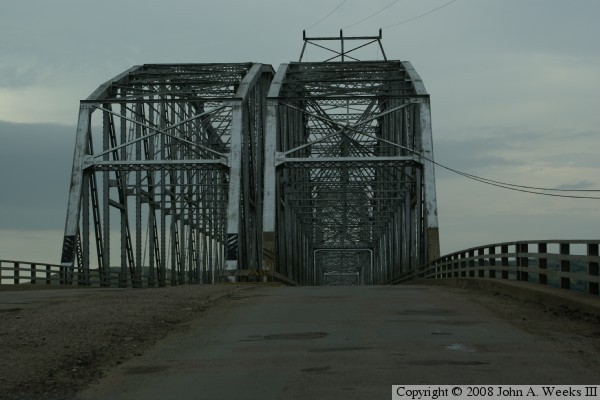
The Chamberlain Bridge was dedicated on September 25, 1925. It consisted of four spans of 336-feet each. The truss sections were made of steel and were riveted together.

The Chamberlain Bridge was very narrow. It was suitable for two cars from the 1920s to meet, but it was grossly inadequate for 1950s era truck traffic. In addition, the Fort Randall Dam project was in the works. That dam would cause the water level of Chamberlain to raise considerably. The 1925 bridge would have only a very low clearance for navigation traffic. The net result is that the bridge needed to be replaced to accommodate more traffic and take into account the higher traffic level.

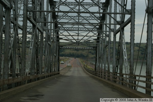
While a new bridge was needed at Chamberlain, there was no money for a wholesale replacement. As a result, a plan was devised to relocate the existing bridge at a new spot in the river, and add a parallel twin span. The new bridge would be located just downstream of the old bridge, and be oriented more east and west than the old bridge. At the same time, the bridge at Wheeler was being flooded out by the Gavins Point Dam. The plan that evolved was to use the four bridge sections from Chamberlain bridge to create the eastern two sections of both the north and south spans of the new bridge. These sections were each 336 feet. Then the five 256-foot sections of the Wheeler Bridge would be floated up stream and be used as three sections on the north span and two sections on the south span. One additional 256-foot section was built new to complete the project. The newly rebuilt and relocated Chamberlain Bridge opened up on December 7, 1953.

To keep traffic moving while the Chamberlain Bridge was being rebuilt, the highway department borrowed and installed a WW-II era Bailey Bridge across the Missouri River. The very day that the newly rebuilt bridge opened, an unseasonable flood caused the Missouri River to rise. The flooded river washed out the temporary Bailey Bridge.

The Interstate Highway Act established that I-90 would pass through the south side of Chamberlain. The US-16 bridge did not meet interstate highway standards, and it would have required interstate traffic to pass though downtown Chamberlain, both of which were unacceptable to the Federal Highway Commission. As a result, a new I-90 bridge was built in Chamberlain in 1974. The US-16 bridge remained in place for local traffic. US-16 was decommissioned as a US highway in 1979, so the bridge now carries SD-248 and the I-90 Business Loop.

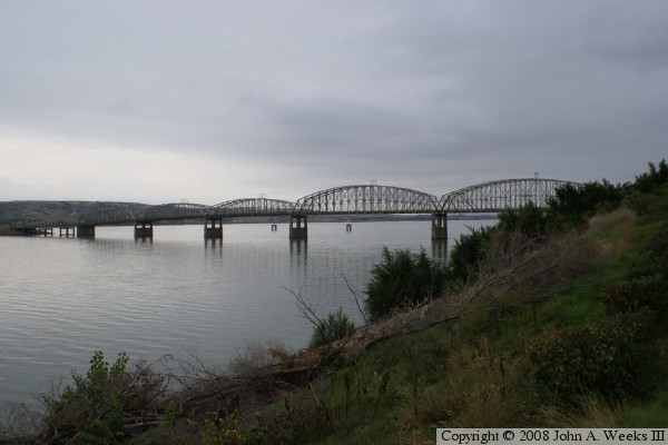
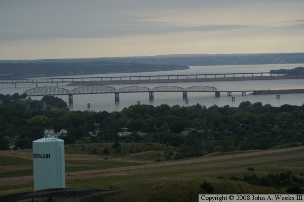
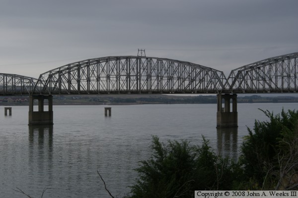
The Chamberlain-Oacoma Bridge is slated to get a major face-lift in 2008. Meanwhile, the five main piers from the original Chamberlain Bridge are still visible sticking up out of the Missouri River water some 600 feet up stream of the Chamberlain-Oacoma Bridge. Two of those piers are visible in the photo above, and all five are included in the photo at the bottom of this page.


Chamberlain-Oacoma Bridge

Made With Macintosh
Authored by John A. Weeks III, Copyright © 1996—2016, all rights reserved.
For further information, contact: john@johnweeks.com