Current Weather Conditions
John A. Weeks III
Thursday, April 18, 2024, 10:05:57 AM CDT
Home Photo Tours Rail Fan 12 Easy Steps
Aviation Spacecraft Highways & Bridges About The Author
 
Google Search
Maps   Groups   Images   Search
 
  Home
  • 12 Easy Steps
  • Aviation
  • Spacecraft
  • Highways & Bridges
    » Bridge Photography
      - MSP River Bridges
      - C & D Canal
      - Illinois River
      - Minnehaha Creek
      - Minnesota River
        › Ortonville - Odessa
        › Correll - Wegdahl
        › Granite Fls - Rdwd Fls
          · BNSF RR Gran Falls
          · Oak Street Bridge
          · Granite Falls Dam
          · The Walking Bridge
          · US-212 Bridge (GF)
          · Minnesota Falls Dam
          · Williams Pipeline Br
          · Ren Co 10 YM Co 21
          · Ren Co 9 RW Co 7
          · Ren Co 12 RW Co 19
          · Ren Co 6 RW Co 6
          · Ren Co 21 RW Co 17
          · R Co 1 RW Co 101 B
          · R Co 1 RW Co 101
        › Morton - Judson
        › Mankato - Jordan
        › MSP West Metro
        › MSP South Metro
      - Mississippi River
      - Missouri River
      - St. Croix River
      - St. Louis River
      - Wisconsin River
      - Best Miss River Photos
      - Cable Stayed Bridges
      - McGilvray Road Bridges
      - I-35W Bridge Disaster
      - Miscellaneous Bridges
      - Madison County Bridges
      - Hist Br Weekend 2013
    » Road Geek Topics
  • Photo Tours
  • Rail Fan
  • About The Author
 
Site Search By JRank
Highways, Byways, And Bridge Photography
Renville Co 10 - Yellow Medicine Co 21 Br
Minnesota River Highway Crossing
Sacred Heart, MN

Renville Co 10 - Yellow Medicine Co 21 Bridge

• Structure ID: NBI: 87505.
• Location: River Mile 238.0.
• River Elevation: 862 Feet.
• Highway: Renville Co 10, Yellow Medicine Co 21.
• Daily Traffic Count: 355 (2001).
• Bridge Type: Steel Girder, Concrete Deck.
• Length: 331 Feet Overall, 125 Foot Longest Span.
• Width: 30 Feet, 2 Lanes.
• Navigation Channel Width: Non-Navigable.
• Height Above Water: 11 Feet.
• Date Built: 1968.
The County 10 - County 2 bridge is a very typical steel girder bridge with a concrete deck and the older style guardrails. The distinguishing features of this bridge are the baby blue color of the girders and the solid rectangular piers. This bridge is one of several similar bridges in rural Renville County that crosses the Minnesota River using county roads. The common theme is that these bridges were all built about the same time, they are all about the same dimensions, and they are all in good shape today.

This bridge is located at the eastern edge of the Lower Sioux Agency State Park. This state park was set aside to preserve the location of the support center for the Dakota when they were moved to reservations, and to preserve the location of the Dakota uprising in 1862.

The photo above is looking north down the length of the bridge deck towards Renville County from the center of Yellow Medicine County highway 21. The photo below is a view looking north across the Minnesota River along the upriver west face of the bridge.


Renville Co 10 - Yellow Medicine Co 21 Bridge
The photo above is looking north down the length of the bridge deck from the 
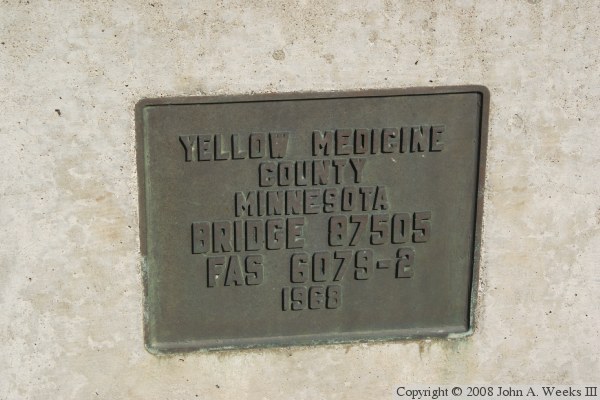
southwest corner of the structure. The photo below is the bridge plate.

Renville Co 10 - Yellow Medicine Co 21 Bridge

Made With Macintosh
Authored by John A. Weeks III, Copyright © 1996—2016, all rights reserved.
For further information, contact: john@johnweeks.com