Current Weather Conditions
John A. Weeks III
Saturday, April 20, 2024, 8:02:15 AM CDT
Home Photo Tours Rail Fan 12 Easy Steps
Aviation Spacecraft Highways & Bridges About The Author
 
Google Search
Maps   Groups   Images   Search
 
  Home
  • 12 Easy Steps
  • Aviation
  • Spacecraft
  • Highways & Bridges
    » Bridge Photography
      - MSP River Bridges
      - C & D Canal
      - Illinois River
      - Minnehaha Creek
      - Minnesota River
      - Mississippi River
        › Lake Itasca Area
        › Bemidji Area
        › Cass Lake - Ball Club
        › Grand Rapids Area
        › Blackberry - Crosby
        › Brainerd Lakes Area
        › Little Falls Area
        › St. Cloud Area
        › North Metro Area
        › Port Of Minneapolis
        › St. Anthony Falls Area
        › Mississippi Rvr Gorge
        › St. Paul Area
        › S St. Paul - Hastings
        › Red Wing - Winona
        › La Crosse Area
        › Lansing - Clinton
          · Lock & Dam #8
          · Black Hawk Bridge
          · Big Slough Bridge
          · Stevens Slough Br
          · Henderson Slough Br
          · Winneshiek Slough Br
          · Lock & Dam #9
          · Washington Street
          · Blackhawk Avenue
          · Twin Suspension Br
          · Marquette-Joliet Br
          · East Channel Bridge
          · WI Street Bridge
          · Iowa Street Bridge
          · St. Feriole Is RR
          · Lock & Dam #10
          · Lock & Dam #11
          · Eagle Point Bridge
          · Dubuque-Wisconsin
          · City Island Bridge
          · 16th Street Bridge
          · CN RR Bridge
          · Julien Dubuque Br
          · Lock & Dam #12
          · Savanna-Sabula Br
          · Running Slough Br
          · Sabula Rail Bridge
          · Lock & Dam #13
          · Lyons-Fulton Bridge
          · Gateway Bridge
          · Sunfish Slough Br
          · C&NW Clinton Br
          · C&NW IL Ch RR
          · C&NW Sunfish Sl
        › Quad Cities Area
        › Muscatine - Louisiana
        › St. Louis Area
        › Chester - Cairo
        › Miss - Tenn - Ark
        › Ark - Miss - Louisiana
        › Louisiana Structures
      - Missouri River
      - St. Croix River
      - St. Louis River
      - Wisconsin River
      - Best Miss River Photos
      - Cable Stayed Bridges
      - McGilvray Road Bridges
      - I-35W Bridge Disaster
      - Miscellaneous Bridges
      - Madison County Bridges
      - Hist Br Weekend 2013
    » Road Geek Topics
  • Photo Tours
  • Rail Fan
  • About The Author
 
Site Search By JRank
Highways, Byways, And Bridge Photography
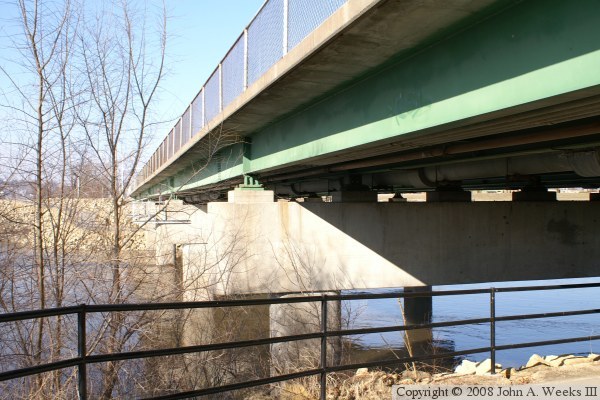
16th Street Bridge
16th Street Mississippi River Crossing At Dubuque
Dubuque, Iowa

16th Street Bridge

• Structure ID: NBI 000000000605410.
• Location: River Mile 580.7.
• River Elevation: 592 Feet.
• Highway: East 16th Street.
• Daily Traffic Count: 10,000 (2001).
• Bridge Type: Steel Girder, Concrete Deck.
• Length: 347 Feet Overall, 70 Foot Longest Span.
• Width: 52 Feet, 4 Lanes.
• Navigation Channel Width: 60 Feet (Estimated).
• Height Above Water: 23 Feet.
• Date Built: Opened 1982.
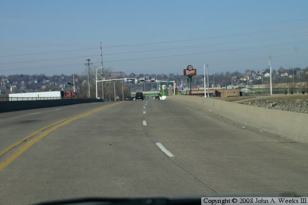
The new Dubuque-Wisconsin Bridge was built in 1982, but the new waterfront expressway through Dubuque was still on the drawing board for another 10 years. In the interim, US-61 and US-151 traffic used a new bridge built across the Peosta Channel of the Mississippi River to enter Dubuque on East 16th Street. Now that the new City Island Bridge and the waterfront expressway are complete, the 16th Street Bridge is no longer a US highway, but it is still an integral part of the city street network near the waterfront serving a marina and a major casino.

16th Street Bridge

Made With Macintosh
Authored by John A. Weeks III, Copyright © 1996—2016, all rights reserved.
For further information, contact: john@johnweeks.com