| Highways, Byways, And Bridge Photography |
Point Douglas Drawbridge
US-10 Saint Croix River Crossing
Prescott, WI
|
• Structure ID: |
NBI: 82010 (MN), B47004000000000 (WI). |
|
• Location: |
River Mile 0.3. |
|
• River Elevation: |
675 Feet. |
|
• Highway: |
US-10. |
|
• Daily Traffic Count: |
13,000 (2002). |
|
• Bridge Type: |
Steel Girder With Draw Section. |
|
• Length: |
672 Feet. |
|
• Width: |
54 Feet, 4 Traffic Lanes. |
|
• Navigation Channel Width: |
160 Feet. |
|
• Height Above Water: |
20 Feet. |
|
• Date Built: |
1990. |
The Point Douglas Drawbridge has an uncommon design. Most drawbridges
have a large counterweight to balance the weight of the roadway sections
that are lifted. That design is known as a bascule bridge. The Point
Douglas Drawbridge does not use counter-weights, so it is not a bascule
bridge. Rather, the end of the bridge has a large round gear on it, and
matching flat gear that is operated by hydraulics. To open the bridge, the
flat gear is moved, which causes the round gear to spin, which tips the
bridge deck up into the air. The Point Douglas Drawbridge is the only
drawbridge in the metro area.
Prior to the Point Douglas Drawbridge being completed, a lift bridge known
as the Prescott Bridge carried US-10 across the Saint Croix River. The lift
bridge was built in 1922. It was designed by the firm of Waddell &
Harrington. Waddell was the developer and early pioneer of the lift bridge,
a design that was attempted after the War Department banned swing bridges
on the Chicago River, and an alternative was needed. Waddell's first bridge
had mechanical problems, so he teamed with Harrington, a skilled mechanical
engineer. The bridge had spans of 172 feet, 174 feet, and 192 feet. Each of
these spans were through truss spans, with the 174 foot span being the lift
span.
The Prescott Bridge was built by a local group of businessmen attempting to
revitalize the economy of Prescott as the logging boom was winding down.
While the bridge was successful and played a key part in the regional
transportation system, it never brought the growth to Prescott that was
hoped for. The state took over the bridge in 1946 and removed the tolls.
By the mid-1960s, the bridge was becoming obsolete. Highway traffic had
picked up to the point where opening the bridge caused large backups.
The vertical clearance for the highway was low causing a hardship for
truckers as well as an increasing number of trucks striking the bridge.
Since the clearance in the down position was only 16 feet, the bridge had
to be frequently operated in the summer for recreational boaters.
The state of Wisconsin identified the Prescott Bridge to be included in a
program to replace high priority bridges starting in 1969. This bridge,
however, never actually received funding from that program. It wasn't until
1989 that the bridge replacement was started, with the new bridge being
opened in 1990. The lift bridge was removed that year, but the bridge piers
remain in place acting as barricades to protect the north side of new draw
bridge from boat and barge strikes.
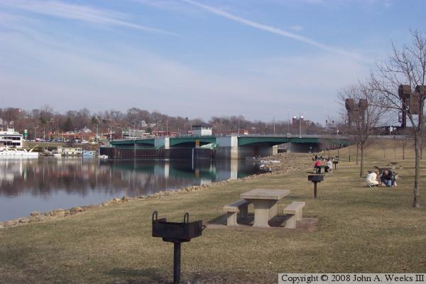
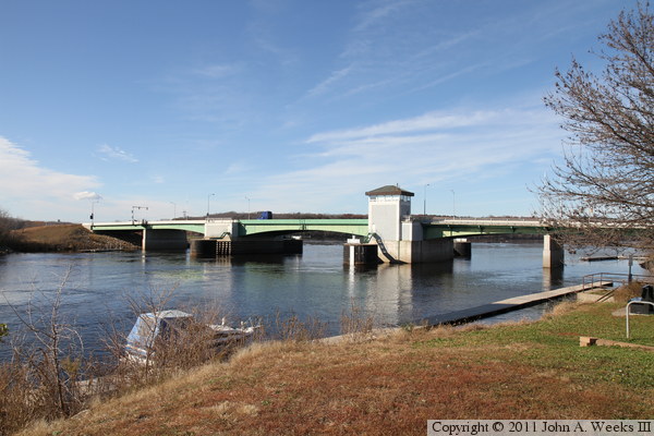
The photo above is a view of the bridge taken from the park on the west
side of the river. The park is located on a thin strip of land that
separates the Saint Croix River from the Mississippi River. The BNSF
Railroad lift bridge is visible on the right side of the photo. The
Saint Croix joins the Mississippi just to the right of the railroad
bridge. The city of Prescott, Wisconsin, is located on the east side
of the river.
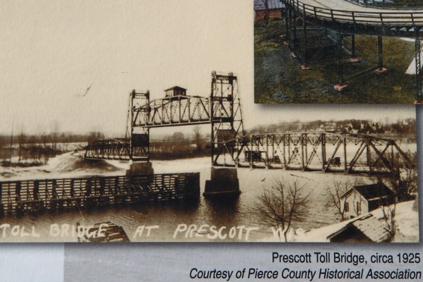
The image above is a photo on a guide sign located along the riverfront in
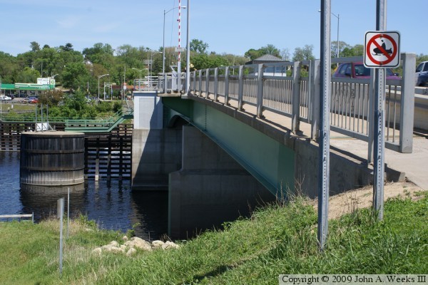
Prescott showing the old lift bridge crossing the Saint Croix River. The
photo below is a view of the upstream north face of the drawbridge from the
east side of the river. The concrete blocks located in the water near the
bridge piers are the piers of the old lift bridge. Note that the old piers
and the large pile are connected with a walkway. This walkway has an access
door coming out of the side of the lift bridge machinery room.


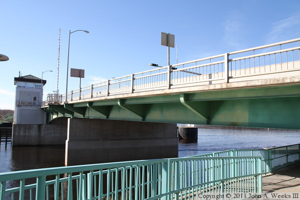
The photo above is a profile view of the south face of the bridge as seen
from the riverfront in Prescott on the east side of the Saint Croix River.
The BNSF Railroad lift bridge is directly behind the vantage point of the
photographer in this shot, with the Mississippi River being on the far
side of the railroad lift bridge. The photo below is a view of the north
face of the bridge as seen from the northwest corner of the structure.
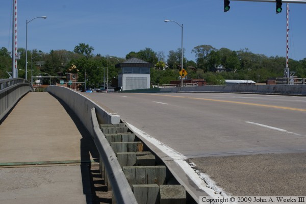
These two photos are views of the bridge deck taken from sidewalk level.
The photo above is looking east across the span towards the city of
Prescott. The photo below is looking west towards Minnesota from the
Wisconsin side of the bridge.
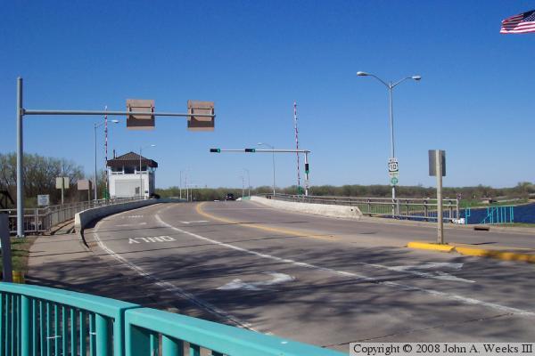
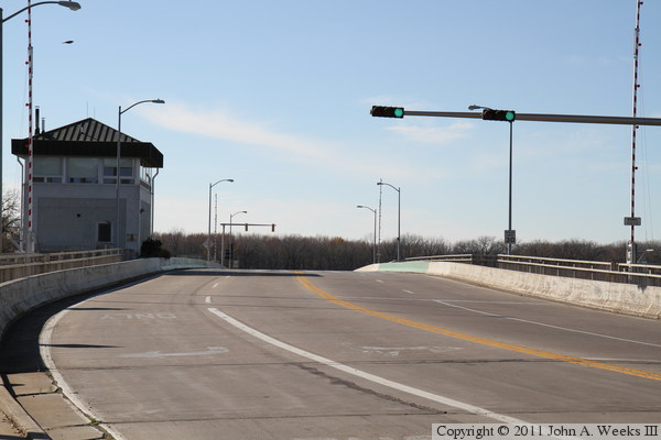
The photo above is the first of four photos to show a typical river crossing
from the west heading east into Wisconsin. In the photo above, we are
rounding a fairly sharp and tight curve at the west end of the bridge.
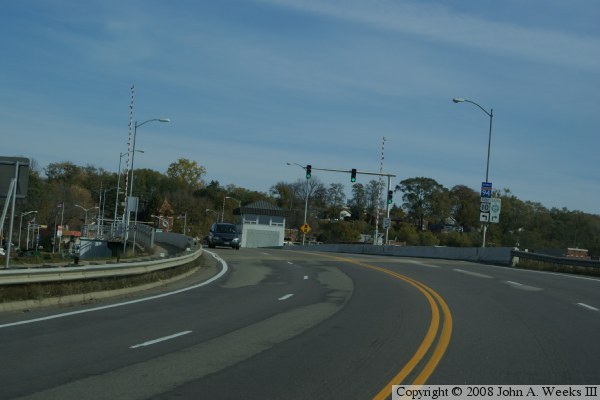
In the photo below, we have entered the west end of the bridge.

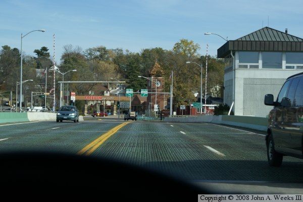
In the photo above, we are entering onto the deck of the lift span. The lift
span uses a steel grate as the floor of the span. The small building to the
right of the roadway is the control building for the bridge. The photo
below is a view where we are exiting the east end of the bridge and are
heading into Wisconsin territory.
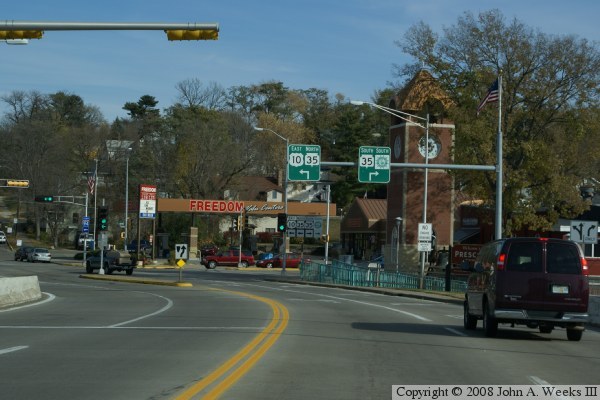
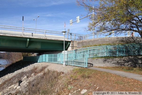
The photo above is looking west down the length of the bridge deck from the
Wisconsin side of the river. The sidewalk on the downstream south side of
the bridge is off limits to pedestrians and only allows access to the bridge
tender tower. The photo below is looking west along the south face of the
Point Douglas Drawbridge. The first two spans are fixed, with the movable
spans being located on the far side of the bridge tender tower.
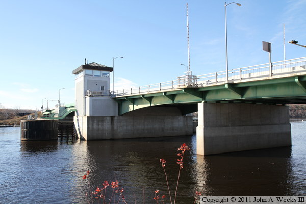
The photo above is another view of the first two fixed spans on the east side
of the main river channel. The large object in the water in front of the
tower is a dolphin, a structure that was built to protect the bridge tower
and machine room from barge strikes. The Saint Croix River typically does
not see barge traffic, but Mississippi River is only a few hundred feet
downstream, so lost tow boat or loose barge could still be a danger. The
photo below is the east abutment. The walkway under the bridge allows easy
access to the walkway on the north side of the bridge from downtown Prescott
without having to cross traffic at street level.

These two photos are looking upstream towards the south face of the Point
Douglas Drawbridge from the east shore of the Saint Croix River. The photo
above was taken from the abutment of the old CB&Q railroad swing bridge,
while the photo below was taken from very near the BNSF railroad lift bridge.

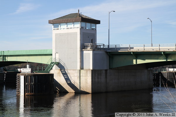
The photo above is a close view of the draw spans. The photo below is a
close view of the east main bridge pier and bridge tender tower. The main
bridge piers house the equipment used to lift the draw spans.
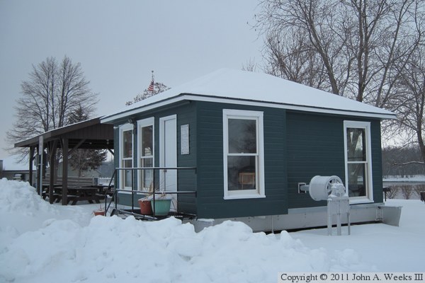
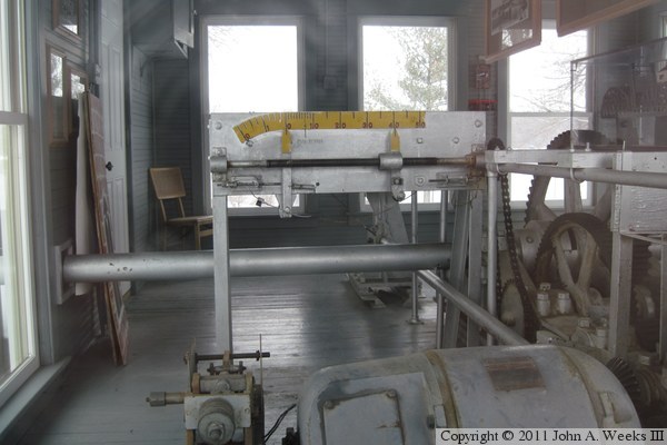
The mechanical room from the old lift bridge was saved and has been put on
display in Mercord Mill Park on the riverfront just south of the BNSF lift
bridge. The photo above is the exterior of the building. It is sitting on
a section of steel from the top of the lift truss span. The photo below is
the interior of the equipment room. The bridge was originally powered by a
gasoline engine. That engine was replaced once while the bridge was still
privately owned, and then the state of Wisconsin replaced the engine with an
electric motor in the late 1940s.

The photo above is one of two remaining original bridge builder plates from
the Prescott Bridge. Both bridge plates are attached to the outside of the
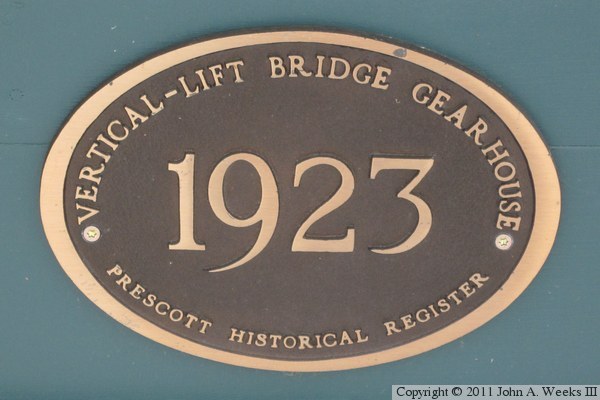
mechanical room for display. The photo below is plaque that has been
installed by the local historical society.
|
