Current Weather Conditions
John A. Weeks III
Saturday, July 27, 2024, 2:35:55 AM CDT
Home Photo Tours Rail Fan 12 Easy Steps
Aviation Spacecraft Highways & Bridges About The Author
 
Google Search
Maps   Groups   Images   Search
 
  Home
  • 12 Easy Steps
  • Aviation
  • Spacecraft
  • Highways & Bridges
    » Bridge Photography
      - MSP River Bridges
      - C & D Canal
      - Illinois River
        › Joliet - La Salle
        › Peru - Peoria
          · IL-251 Bridge
          · Spring Valley Bridge
          · G Sonny Jessen Br
          · Henry Bridge
          · Lacon Bridge
          · Chillicothe Rail Br
          · McClugage Bridge
          · Murray Baker Bridge
          · Bob Michel Bridge
          · Cedar Street Bridge
          · Tazewell & Peoria RR
          · Shade-Lohmann Br
          · Peoria Lock & Dam
        › Pekin - Beardstown
        › LaGrange - Grafton
      - Minnehaha Creek
      - Minnesota River
      - Mississippi River
      - Missouri River
      - St. Croix River
      - St. Louis River
      - Wisconsin River
      - Best Miss River Photos
      - Cable Stayed Bridges
      - McGilvray Road Bridges
      - I-35W Bridge Disaster
      - Miscellaneous Bridges
      - Madison County Bridges
      - Hist Br Weekend 2013
    » Road Geek Topics
  • Photo Tours
  • Rail Fan
  • About The Author
 
Site Search By JRank
Highways, Byways, And Bridge Photography
Tazewell & Peoria Railroad Bridge
Illinois River Railroad Crossing
Peoria, IL

Tazewell & Peoria Railroad Bridge

• Structure ID: N/A
• Location: River Mile 160.7
• River Elevation: 440 Feet
• Railroad: Tazewell & Peoria Railroad
• Daily Traffic Count: 20 Trains Per Day (Estimated)
• Bridge Type: Steel Truss W/Lift Span
• Bridge Length: 1,075 Feet (Estimated), 350 Foot Longest Span (Estimated)
• Bridge Width: ??? Feet, 2 Tracks
• Navigation Channel Width: 307 Feet
• Height Above Water: 19 Feet
• Date Built: 1909
The Tazewell & Peoria was formed to operate the assets of the former Peoria & Pekin Union Railway. The T&P handles traffic on both sides of the Illinois River handling 100,000 cars per year with trackage rights to 150 miles of track.

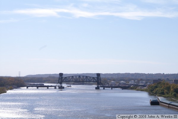
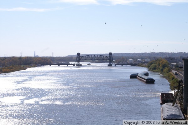
This bridge is the key railroad bridge over the Illinois River in the Peoria area. Several railroads use this bridge including the CN and BNSF, and several industries depend on this bridge including Caterpillar. The bridge dates back to 1909. The original lift mechanism was replaced with a new lift span in 1984. The bridge is operated by remote control from a control tower located at a nearby railroad junction. The bridge is set up for two parallel railroad tracks, but one of the tracks is no longer in use.

These two photos were taken from the Cedar Street with a telephoto lens pointed nearly into the sun. It is surprising that they turned out as well as they did. This was the only location I could find to photograph this bridge. The south side of the bridge is all industrial, so it is off limits. The north side has a rail line and trees, so I wasn't able to find an angle. I did find a sand and gravel yard just south of the bridge where I might be able to sneak a photo or two. I'll try that the next time I pass though Peoria.


Tazewell & Peoria Railroad Bridge

Made With Macintosh
Authored by John A. Weeks III, Copyright © 1996—2016, all rights reserved.
For further information, contact: john@johnweeks.com