Current Weather Conditions
John A. Weeks III
Friday, March 29, 2024, 12:30:32 AM CDT
Home Photo Tours Rail Fan 12 Easy Steps
Aviation Spacecraft Highways & Bridges About The Author
 
Google Search
Maps   Groups   Images   Search
 
  Home
  • 12 Easy Steps
  • Aviation
  • Spacecraft
  • Highways & Bridges
    » Bridge Photography
      - MSP River Bridges
      - C & D Canal
      - Illinois River
      - Minnehaha Creek
      - Minnesota River
      - Mississippi River
      - Missouri River
      - St. Croix River
        › Upper St. Croix River
        › Lower St. Croix River
          · Nevers Dam
          · St. Croix Falls Dam
          · US-8 Bridge
          · Highway 243 Bridge
          · Cedar Bend RR Br
          · Arcola High Bridge
          · WI Central RR Ruin
          · St. Croix Boom Site
          · Stillwater Lift Bridge
          · New St Croix R Br
          · C&NW RR Bridge
          · Walnut Street Cswy
          · Toll Bridge (Old)
          · I-94 Interstate Br
          · Point Douglas Draw
          · BNSF RR Bridge
      - St. Louis River
      - Wisconsin River
      - Best Miss River Photos
      - Cable Stayed Bridges
      - McGilvray Road Bridges
      - I-35W Bridge Disaster
      - Miscellaneous Bridges
      - Madison County Bridges
      - Hist Br Weekend 2013
    » Road Geek Topics
  • Photo Tours
  • Rail Fan
  • About The Author
 
Site Search By JRank
Highways, Byways, And Bridge Photography
Arcola High Bridge
Canadian National Saint Croix River Crossing
Somerset, WI

Arcola High Bridge

• Structure ID: N/A.
• Location: River Mile 28.5.
• River Elevation: 677 Feet.
• Railroad: Canadian National Railroad.
• Daily Traffic Count: 6 Trains Per Day.
• Bridge Type: 5 Steel Arches.
• Length: 2,682 Feet.
• Width: 1 Track.
• Navigation Channel Width: Non-Navigable.
• Height Above Water: 184 Feet (Normal Water Level To Low Steel).
• Date Built: 1909.
The Arcola High Bridge is the most spectacular river crossing in the Twin Cities metro area. It crosses the nearly mile wide Saint Croix River Valley between the village of Arcola, Minnesota, and Somerset, Wisconsin. It consists of five huge steel arches that tower nearly 200 feet over the bottom of the valley.

The bridge was built by the Wisconsin Central Railroad. The WC built a rail line from Milwaukee to Ashland, running more or less north and south. As Minneapolis continued to grow into a regional metropolis, the WC desired to tap into that market. A rail line was extended from the existing WC line in Marshfield to Chippewa Falls, and then into the Twin Cities. This line was completed and opened in 1884.

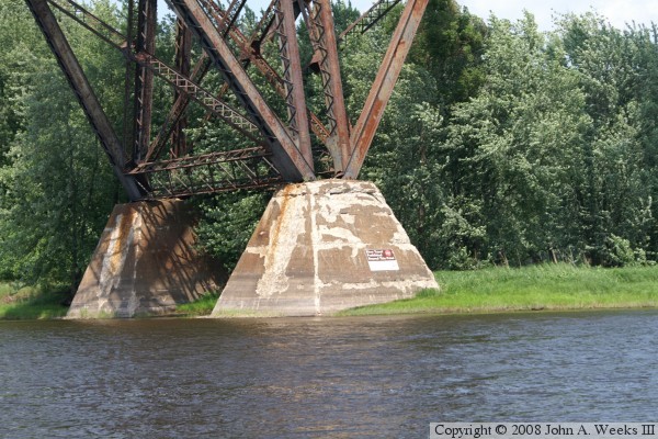
The Saint Croix river was still a problem. A smaller bridge was built across the river at the bottom of the valley. Trains had to face very steep grades on each side of the river crossing. This resulted in shorter trains and required the use of helper engines. The problem was addressed in the early 1900s when famous bridge engineer C.A.P. Turner was brought in. He designed and supervised the building of the big metal monster that survives to this day.

The Wisconsin Central turned over its operations to the Saint Paul and Sault Ste Marie in 1909. The WC went bankrupt in 1932, and the Sault Ste Marie continued to run the WC lines for the bankruptcy trustees. Finally, in 1960, three railroads operating in Wisconsin merged to form the Soo Line Railroad. The Soo continued to run trains over the high bridge. The Soo Line eventually became a part of the Canadian Pacific Railroad, and later took over its rival Milwaukee Road, which also ran trains from Milwaukee to the Twin Cities. The Canadian Pacific decided to downsize and refocus, so the old Wisconsin Central lines were sold to the Canadian National in 2001. As a result, the CN now operates trains over the Arcola High Bridge.

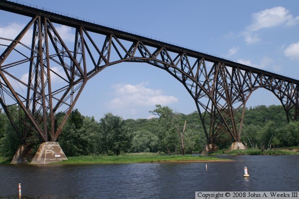
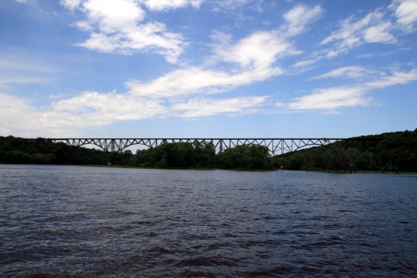
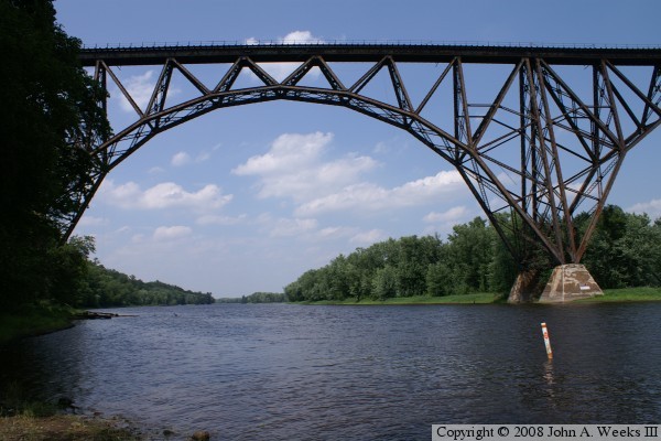
The Arcola High Bridge was added to the National Register of Historical Places in 1977. Experts have called this bridge the most spectacular multi-span steel arch bridge in the world. Others compare the magnificent steel work to that of Eiffel's creations in France. Despite the history and national listing, this amazing bridge is all but unknown in the Twin Cities area, and it is virtually impossible to get a glimpse of the structure without trespassing or taking to the water.

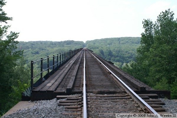
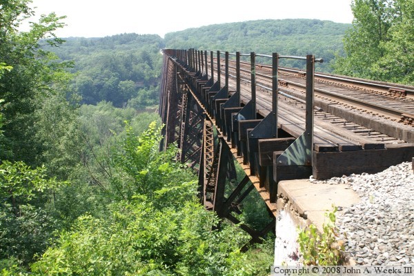
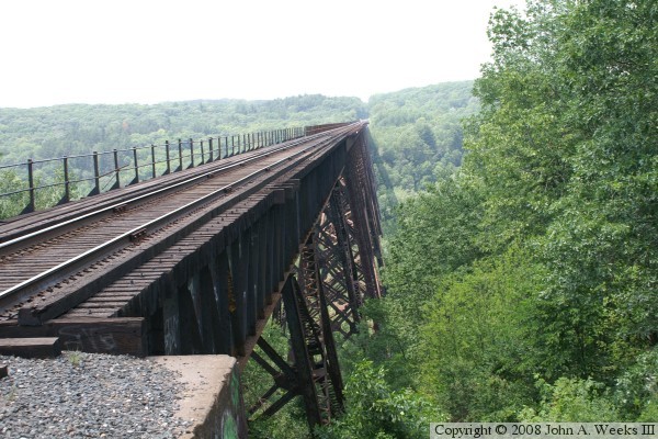
The east abutment of the Arcola High Bridge can be visited with only minimal trespassing. Starting at Stillwater, travel east on WI-64 to Somerset, and exit at the County VV ramp. Follow the local roads that parallel the railroad line going west until you reach the edge of the river bluffs. You will find a spot to park. A short trail leads to end of the bridge.

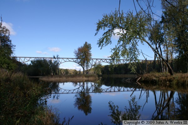
The west riverbank can be visited by following a DNR bird watching trail. There is a small parking area on the side of the Arcola Trail road several miles north of Stillwater. The path to the riverbank is about 4/5 of a mile. In addition, it drops 220 feet, so be prepared for a healthy climb back out of the river valley. The bridge views, however, are worth the effort. The photo above is an example of the views from the west riverbank.

Update—on a sad note, a 20 year old woman was attempting to cross the Arcola High Bridge around 1:00 AM on August 10, 2008, when a plank on the walkway gave out. She fell 200 feet to the ground. Responders pronounced the woman dead at the scene. The 20 year old male that she was with did not fall.

Update—security at the east end of the bridge has been tightened considerably. I have heard reports of regular patrols, video cameras, and motion sensors. Anyone who walks down to the railroad tracks or out to the bridge abutment risks a trespassing fine of up to $500. Local law enforcement agencies have made security at the bridge site a priority, and they can and do respond very quickly.


Arcola High Bridge
The photo above is a view looking west down the length of the railroad deck from the Wisconsin side. The photo below is the south face of the structure. Minnesota is on the far side of the river.

Arcola High Bridge
Arcola High Bridge
The photo above is the north face of the Arcola bridge as seen from the Wisconsin side of the Saint Croix River. The photo below is a view of several bridge spans as seen from the west riverbank.

Arcola High Bridge
Arcola High Bridge
These two photos are two more views from the riverbank on the Minnesota side of the Saint Croix River. The photo above is the second bridge arch when counting from the west end of the bridge. The photo below is a wide angle view of the bridge as it disappears into the trees on the Wisconsin side of the structure.

Arcola High Bridge
Arcola High Bridge
The photo above is looking upriver towards the south face of the Arcola High Bridge. About two-thirds of the bridge is visible in this view. The photo below is a close view of the 2nd and 3rd arches when counting from the west end of the structure.

Arcola High Bridge
Arcola High Bridge
The photo above is a close view of one of the massive bridge footings at the base of the structure. The photo below was taken from a boat by Michael Waterman. It gives a view of just how long this bridge really is.

Arcola High Bridge

Made With Macintosh
Authored by John A. Weeks III, Copyright © 1996—2016, all rights reserved.
For further information, contact: john@johnweeks.com