
The bridge that is built will be very much like the Bloomington Ferry Bridge. Expect a structure that runs at tree-top level between 60 and 75 feet above the river level. Due to the wetlands and the wildlife refuge, expect a bridge that spans the entire river valley, running about 2 to 3 miles in length. Finally, expect a bridge that is built to interstate highway standards with at least 4 lanes, limited access, and freeway interchanges on each end.
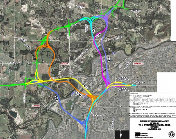
A copy of MN-DOT's proposed alternatives is included below. There are two basic alignments, with 3 options for each alignment. The northern alignment would be best for traffic coming from the south heading to the west side of the metro area. The problem with these alignments is that they would cut through existing residential areas. In fact, one alignment is designed such that it would blast through both of the major trailer house communities in the area. A further issue is the location of Seminary Fen (a fen is a very rare cold water spring fed wetland that has unique plant species). The southern alignment would go though less developed areas, and it would best suit traffic from south of the river that heads to the far western parts of the twin cities metro area. Of the southern alternatives, only C-2 seems to make sense.
The current timeline has the environmental impact statements being done by the end of the year 2007, a preferred alternative picked in early 2008, and the project ready to go into final design by the end of 2008. Beyond that, there is no specific funding for the project, so the start date is unknown. Note—these two graphics were prepared by MN-DOT.
Update—On December 10, 2008, MN-DOT announced that they had selected option C-2 as the preferred alternative. Since the process began, the city of Chaska asked that their ball fields not be destroyed in the process, the Fen areas were declared off limits, and the residents of the Jackson Heights mobile home park somehow obtained the status of a "protected population" through the court system. As a result, the exact routing of the C-2 path will need to be further refined. MN-DOT can now move to the Environmental Impact Statement phase. Note that at this time, the bridge is not on the state 20 year plan, so it is a long way from being a done deal.
