Current Weather Conditions
John A. Weeks III
Friday, March 31, 2023, 12:33:23 AM CDT
Home Photo Tours Rail Fan 12 Easy Steps
Aviation Spacecraft Highways & Bridges About The Author
 
Google Search
Maps   Groups   Images   Search
 
  Home
  • 12 Easy Steps
  • Aviation
  • Spacecraft
  • Highways & Bridges
    » Bridge Photography
      - MSP River Bridges
      - C & D Canal
      - Illinois River
      - Minnehaha Creek
      - Minnesota River
        › Ortonville - Odessa
        › Correll - Wegdahl
        › Granite Fls - Rdwd Fls
        › Morton - Judson
        › Mankato - Jordan
        › MSP West Metro
          · M&StL Bridge
          · MN-41 Bridge (New)
          · MN-41 Bridge (Old)
          · MN-41 Backchannel
          · MN-41 Back Ch (Old)
          · MN-41 Bridge
          · Chaska Trestle
          · Chaska Swing Bridge
          · Holmes St Ped Bridge
          · MN-101 Bridge
          · Lewis Street Bridge
        › MSP South Metro
      - Mississippi River
      - Missouri River
      - St. Croix River
      - St. Louis River
      - Wisconsin River
      - Best Miss River Photos
      - Cable Stayed Bridges
      - McGilvray Road Bridges
      - I-35W Bridge Disaster
      - Miscellaneous Bridges
      - Madison County Bridges
      - Hist Br Weekend 2013
    » Road Geek Topics
  • Photo Tours
  • Rail Fan
  • About The Author
 
Site Search By JRank
Highways, Byways, And Bridge Photography
New Trunk-41 Bridge
Proposed MN-41 Minnesota River Crossing
Chaska, MN

New Trunk-41 Freeway Bridge

• Structure ID: Proposed.
• Location: Between River Miles 29 and 33.
• River Elevation: 695 Feet.
• Highway: MN-41.
• Daily Traffic Count: To Be Determined.
• Bridge Type: To Be Determined.
• Length: 2 To 3 Miles (Estimated).
• Width: 4 Lanes.
• Navigation Channel Width: Non-Navigable.
• Height Above Water: 75 Feet (Estimated).
• Date Built: To Be Determined.
The Minnesota River creates a significant traffic bottleneck in the southwestern areas of the Twin Cities metro area. There are only two river crossings past the Bloomington Ferry Bridge, and both of them are low level bridges that are prone to backing up. The MN-101 bridge cannot be upgraded to a freeway because one end lands in downtown Shakopee. The MN-41 bridge similarly lands in downtown Chaska. Traffic on MN-41 is already over 18,000 vehicles a day, making it one of the busiest two lane bridges in the state. The completion of the new US-212 freeway is only going to increase traffic on MN-41 given its strategic location between the US-212 and US-169 freeways.

The bridge that is built will be very much like the Bloomington Ferry Bridge. Expect a structure that runs at tree-top level between 60 and 75 feet above the river level. Due to the wetlands and the wildlife refuge, expect a bridge that spans the entire river valley, running about 2 to 3 miles in length. Finally, expect a bridge that is built to interstate highway standards with at least 4 lanes, limited access, and freeway interchanges on each end.

A copy of MN-DOT's proposed alternatives is included below. There are two basic alignments, with 3 options for each alignment. The northern alignment would be best for traffic coming from the south heading to the west side of the metro area. The problem with these alignments is that they would cut through existing residential areas. In fact, one alignment is designed such that it would blast through both of the major trailer house communities in the area. A further issue is the location of Seminary Fen (a fen is a very rare cold water spring fed wetland that has unique plant species). The southern alignment would go though less developed areas, and it would best suit traffic from south of the river that heads to the far western parts of the twin cities metro area. Of the southern alternatives, only C-2 seems to make sense.

The current timeline has the environmental impact statements being done by the end of the year 2007, a preferred alternative picked in early 2008, and the project ready to go into final design by the end of 2008. Beyond that, there is no specific funding for the project, so the start date is unknown. Note—these two graphics were prepared by MN-DOT.

Update—On December 10, 2008, MN-DOT announced that they had selected option C-2 as the preferred alternative. Since the process began, the city of Chaska asked that their ball fields not be destroyed in the process, the Fen areas were declared off limits, and the residents of the Jackson Heights mobile home park somehow obtained the status of a "protected population" through the court system. As a result, the exact routing of the C-2 path will need to be further refined. MN-DOT can now move to the Environmental Impact Statement phase. Note that at this time, the bridge is not on the state 20 year plan, so it is a long way from being a done deal.

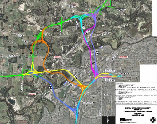
New Trunk-41 Freeway Bridge

Made With Macintosh
Authored by John A. Weeks III, Copyright © 1996—2016, all rights reserved.
For further information, contact: john@johnweeks.com