Current Weather Conditions
John A. Weeks III
Sunday, May 5, 2024, 11:22:25 PM CDT
Home Photo Tours Rail Fan 12 Easy Steps
Aviation Spacecraft Highways & Bridges About The Author
 
Google Search
Maps   Groups   Images   Search
 
  Home
  • 12 Easy Steps
  • Aviation
  • Spacecraft
  • Highways & Bridges
    » Bridge Photography
      - MSP River Bridges
      - C & D Canal
      - Illinois River
      - Minnehaha Creek
      - Minnesota River
      - Mississippi River
        › Lake Itasca Area
        › Bemidji Area
        › Cass Lake - Ball Club
        › Grand Rapids Area
        › Blackberry - Crosby
        › Brainerd Lakes Area
        › Little Falls Area
        › St. Cloud Area
        › North Metro Area
        › Port Of Minneapolis
        › St. Anthony Falls Area
        › Mississippi Rvr Gorge
        › St. Paul Area
        › S St. Paul - Hastings
        › Red Wing - Winona
        › La Crosse Area
        › Lansing - Clinton
        › Quad Cities Area
        › Muscatine - Louisiana
        › St. Louis Area
        › Chester - Cairo
          · Chester Bridge
          · Texas-Illinois Pipeline
          · Bill Emerson Mem Br
          · Thebes Bridge
          · I-57 Bridge
          · US-60/US-62 Bridge
        › Miss - Tenn - Ark
        › Ark - Miss - Louisiana
        › Louisiana Structures
      - Missouri River
      - St. Croix River
      - St. Louis River
      - Wisconsin River
      - Best Miss River Photos
      - Cable Stayed Bridges
      - McGilvray Road Bridges
      - I-35W Bridge Disaster
      - Miscellaneous Bridges
      - Madison County Bridges
      - Hist Br Weekend 2013
    » Road Geek Topics
  • Photo Tours
  • Rail Fan
  • About The Author
 
Site Search By JRank
Highways, Byways, And Bridge Photography
Chester Bridge
Il-150/Mo-51 Mississippi River Crossing At Chester
Chester, Illinois

Chester Bridge

• Structure ID: NBI 000079600117420 (IL), 6656 (MO).
• Location: River Mile 109.9.
• River Elevation: 338 Feet.
• Highway: Il-150, Mo-51.
• Daily Traffic Count: 7,772 (2002), 7,258 (2004).
• Bridge Type: Steel Through Truss, Two Deck Truss Approach Spans.
• Length: 2,826 Feet, 670 Foot Main Span.
• Width: 22 Feet, 2 Traffic Lanes.
• Navigation Channel Width: 650 Feet.
• Height Above Water: 104 Feet.
• Date Built: Opened August 23, 1942.
The Chester Bridge is a lesser known Mississippi River crossing given that it is nowhere near any larger cities. This bridge was a toll bridge until Dec 31, 1988. The state line runs along the center of the river channel at this location. As a result, the east end of the bridge is designated IL-150, while the west end of the bridge is MO-51.

The main truss structure of the bridge was destroyed in a storm in July of 1944. The truss was rebuilt, but the bridge was closed for 2 years during the reconstruction.

Chester is the home town of Elzie Crisler Segar, the cartoonist who created ‘Popeye The Sailor Man’. There is a small park on the Illinois side of the crossing to remember Segar, which includes a life-sized statue of Popeye. The city celebrates Segar in the annual Popeye Festival held each labor day weekend.

The village of Kaskaskia is located on the west side of the Mississippi River just upriver of Chester. Kaskaskia was a commercial and transportation hub in the 1800s. In fact, it was the first capital of Illinois until 1820. The Mississippi River shifted course to the east side of Kaskaskia in the middle and late 1800s. As a result, the village is now located on the west side of the Mississippi River. But since the state line follows the historic path of the Mississippi River, Kaskaskia remains a part of the state of Illinois. The fortunes of Kaskaskia started to wane following the shifting of the river. Its population steadily declined throughout the 1900s with only 9 people remaining in 2000.

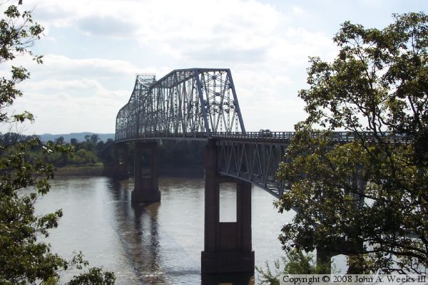
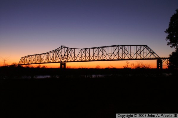
The photo above is looking northwest towards the Chester Bridge just after the sun has set behind the river bluffs on the west side of the Mississippi River. The photo below is a view from the edge of the river bluff on the east side of the river from a vantage point located near the Popeye statue.


Chester Bridge
Chester Bridge
The photo above is a view looking west from the northeast corner of the bridge. The photo below is a view looking west from the edge of the westbound traffic lane.

Chester Bridge

Made With Macintosh
Authored by John A. Weeks III, Copyright © 1996—2016, all rights reserved.
For further information, contact: john@johnweeks.com