Current Weather Conditions
John A. Weeks III
Friday, April 19, 2024, 6:59:01 AM CDT
Home Photo Tours Rail Fan 12 Easy Steps
Aviation Spacecraft Highways & Bridges About The Author
 
Google Search
Maps   Groups   Images   Search
 
  Home
  • 12 Easy Steps
  • Aviation
  • Spacecraft
  • Highways & Bridges
    » Bridge Photography
      - MSP River Bridges
      - C & D Canal
      - Illinois River
      - Minnehaha Creek
      - Minnesota River
        › Ortonville - Odessa
        › Correll - Wegdahl
        › Granite Fls - Rdwd Fls
        › Morton - Judson
          · US-71 Bridge (Old)
          · US-71 Bridge (Back)
          · US-71 Bridge (Main)
          · Sulphur Lake Bridge
          · MN Valley Railroad
          · Ren Co 5 Brn Co 11
          · Petersen Bridge
          · MN-4 Bridge
          · Hinderman Bridge
          · Beussmann Bridge
          · US-14 Bridge (NU)
          · Nicollet Co 37 Br
          · Redstone Bridge
          · Nic Co 24 BE Co 45
          · Nic Co 23 BE Co 42
        › Mankato - Jordan
        › MSP West Metro
        › MSP South Metro
      - Mississippi River
      - Missouri River
      - St. Croix River
      - St. Louis River
      - Wisconsin River
      - Best Miss River Photos
      - Cable Stayed Bridges
      - McGilvray Road Bridges
      - I-35W Bridge Disaster
      - Miscellaneous Bridges
      - Madison County Bridges
      - Hist Br Weekend 2013
    » Road Geek Topics
  • Photo Tours
  • Rail Fan
  • About The Author
 
Site Search By JRank
Highways, Byways, And Bridge Photography
Nicollet Co 24 - Blue Earth Co 45 Bridge
Minnesota River Highway Crossing
Courtland, MN

Nicollet Co 24 - Blue Earth Co 45 Bridge

• Structure ID: NBI: 52504.
• Location: River Mile 140.0.
• River Elevation: 778 Feet.
• Highway: Nicollet Co 24, Blue Earth Co 45.
• Daily Traffic Count: 1,000 (2003).
• Bridge Type: Steel Girder, Concrete Deck.
• Length: 567 Feet, 123 Foot Longest Span..
• Width: 32 Feet, 2 Lanes.
• Navigation Channel Width: Non-Navigable.
• Height Above Water: 30 Feet.
• Date Built: 1973.
This bridge located near the small town of Courtland, MN, was built to connect highways that run parallel to the Minnesota River. That includes US-14 on the north side of the river and MN-68 on the south side of the river. Two very short county highways connect the bridge to the larger highways. On the north side, Nicollet County Highway 24 is about 1 mile in length. On the south side, Blue Earth County Highway 45 is about a third of a mile.

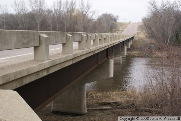
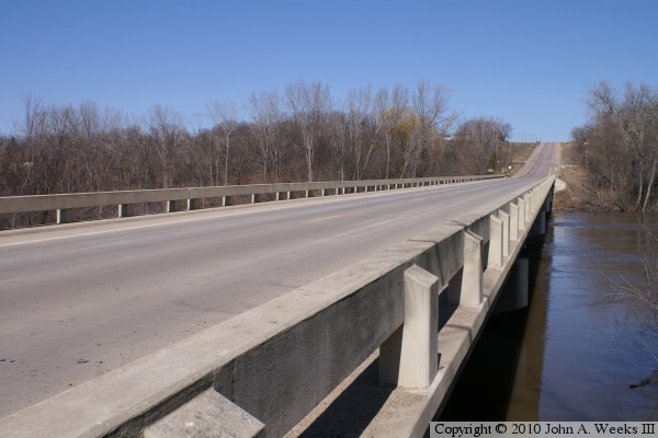
The highway 24 and highway 42 bridge is a modern steel girder bridge with a concrete highway deck. It has the older style guard rails with openings to the side. These guard rails are considered to be obsolete since debris and salty slush on the bridge deck can easily end up in the river. The bridge has 4 main piers and two abutments, both made of reinforced concrete. These structures support three spans of 123 feet in the middle, and one span of 95 feet on each end. The bridge steel sits about 30 feet above typical water levels with the river typically being 3 to 5 feet deep in this area.

While I was not able to find any information about previous bridges at this location, this bridge is certainly not the first Minnesota River crossing near Courtland. In fact, a ferry boat crossed the river at this location as early as 1854.

The photo above is a view looking north across the Minnesota River down the downriver east side of the highway 24 and highway 45 bridge.


Nicollet Co 24 - Blue Earth Co 45 Bridge
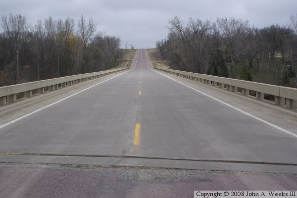
The photo above is looking north down the length of the bridge deck towards Nicollet County from the center of Blue Earth County highway 45. The photo 
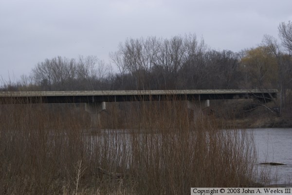
below is looking west towards the downriver east face of the highway 24 and highway 45 bridge from the south bank of the Minnesota River.

Nicollet Co 24 - Blue Earth Co 45 Bridge
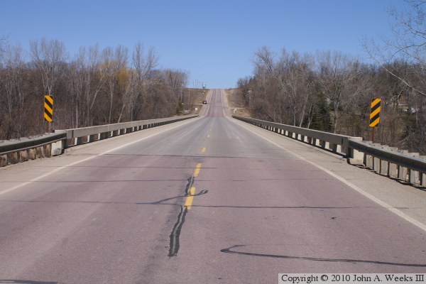
These two photos are from the spring flood of 2010. The photo above is looking north down the center of the bridge, while the photo below is looking along the downriver east face of the structure. The bridge was not underwater during the flood, however, the water did submerge the lower part of the bridge pier arms.

Nicollet Co 24 - Blue Earth Co 45 Bridge
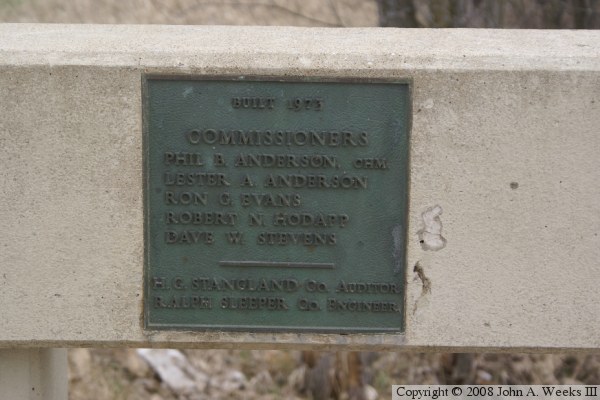
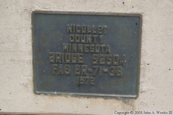
These two photos are plates attached to the bridge. The photo above is a dedication plate, while the photo below is the standard MN-DOT bridge plate.

Nicollet Co 24 - Blue Earth Co 45 Bridge

Made With Macintosh
Authored by John A. Weeks III, Copyright © 1996—2016, all rights reserved.
For further information, contact: john@johnweeks.com