Current Weather Conditions
John A. Weeks III
Thursday, November 30, 2023, 4:35:29 AM CST
Home Photo Tours Rail Fan 12 Easy Steps
Aviation Spacecraft Highways & Bridges About The Author
 
Google Search
Maps   Groups   Images   Search
 
  Home
  • 12 Easy Steps
  • Aviation
  • Spacecraft
  • Highways & Bridges
    » Bridge Photography
      - MSP River Bridges
      - C & D Canal
      - Illinois River
      - Minnehaha Creek
      - Minnesota River
      - Mississippi River
      - Missouri River
      - St. Croix River
      - St. Louis River
        › St. Louis Headwaters
        › Upper St. Louis River
        › Forbes - US-53 Area
          · Town Line Road Br
          · US-53 Bridge (NB)
          · US-53 Bridge (SB)
          · Hawks Trail Bridge
          · DW&P RR Bridge
          · Evtac Road Bridge
          · Forbes Dam
          · CSAH-7 Bridge
          · DM&IR RR Forbes
        › Up Mid St. Louis River
        › Lw Mid St. Louis River
        › Fond du Lac Reservatn
        › Cloquet - Scanlon
        › Jay Cooke State Park
        › Twin Ports Harbor
      - Wisconsin River
      - Best Miss River Photos
      - Cable Stayed Bridges
      - McGilvray Road Bridges
      - I-35W Bridge Disaster
      - Miscellaneous Bridges
      - Madison County Bridges
      - Hist Br Weekend 2013
    » Road Geek Topics
  • Photo Tours
  • Rail Fan
  • About The Author
 
Site Search By JRank
Highways, Byways, And Bridge Photography
Evtac Road Bridge
Private Saint Louis River Highway Crossing
Forbes, MN

Evtac Road Bridge

• Structure ID: N/A
• Location: River Mile 126.9
• River Elevation: 1,312 Feet
• Highways: Evtac Road
• Daily Traffic Count: Not Measured
• Bridge Type: Steel Girder, Concrete Deck
• Bridge Length: 207 Feet (Estimated), 64 Foot Longest Span (Estimated)
• Bridge Width: 22 Feet (Estimated), 2 Lanes
• Navigation Channel Width: Non-Navigable
• Height Above Water 24 Feet
• Date Built: 1963
The Evtac Road Bridge crosses the Saint Louis River on a privately owned road that serves as the entrance to the Evtac mine and taconite processing plant. The bridge is built as part of the Forbes Dam. The bridge is an older style structure. It is narrow, has no walkway for pedestrians, and it has an open metal guardrail. The structure is very simple. It consists of steel I-beams placed across the piers built to support the dam gates.

Evtac opened in 1965 as the Eveleth Mining Company, with Evtac being the operating company. The mine used the new (at the time) process for making taconite out of low grade Iron ore, a process which essentially saved the mining industry across the Iron Range as the high grade ore was becoming harder to find. The mine ran out of orders in 1999 and had to shut down for a few weeks. The mine again shut down in 2003, and it appeared that it would be for good. While in bankruptcy, a bidding war erupted, but both bids were eventually thrown out when a partnership was established with a company from China that opened a new market for Taconite. The company restarted operations at a reduced rate. The company later reincorporated as United Taconite and was sold to Cleveland Cliffs, a global operator of mines. A recent mine expansion project has the facility producing record levels of taconite as of 2008.

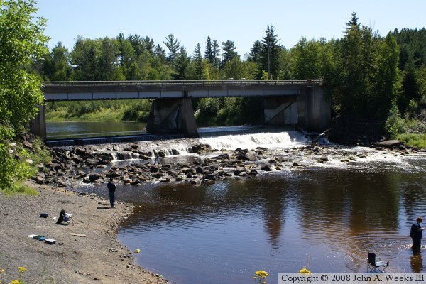
The photo above is looking southeast towards the bridge from the small park that is located on the north bank of the Saint Louis River. This view shows how the bridge is sitting on top of the Evtac Dam.


Evtac Road Bridge
These two photos are views looking south down the length of the bridge deck. The photo above is from the northwest corner of the structure, while the photo above is from the northeast corner of the structure. Signs at both ends of the bridge indicate that this is private property and that traffic is not allowed to travel south of the bridge without permission from the mine operators.

Evtac Road Bridge

Made With Macintosh
Authored by John A. Weeks III, Copyright © 1996—2016, all rights reserved.
For further information, contact: john@johnweeks.com