Current Weather Conditions
John A. Weeks III
Thursday, November 30, 2023, 4:46:10 AM CST
Home Photo Tours Rail Fan 12 Easy Steps
Aviation Spacecraft Highways & Bridges About The Author
 
Google Search
Maps   Groups   Images   Search
 
  Home
  • 12 Easy Steps
  • Aviation
  • Spacecraft
  • Highways & Bridges
    » Bridge Photography
      - MSP River Bridges
      - C & D Canal
      - Illinois River
      - Minnehaha Creek
      - Minnesota River
      - Mississippi River
      - Missouri River
      - St. Croix River
      - St. Louis River
        › St. Louis Headwaters
        › Upper St. Louis River
        › Forbes - US-53 Area
          · Town Line Road Br
          · US-53 Bridge (NB)
          · US-53 Bridge (SB)
          · Hawks Trail Bridge
          · DW&P RR Bridge
          · Evtac Road Bridge
          · Forbes Dam
          · CSAH-7 Bridge
          · DM&IR RR Forbes
        › Up Mid St. Louis River
        › Lw Mid St. Louis River
        › Fond du Lac Reservatn
        › Cloquet - Scanlon
        › Jay Cooke State Park
        › Twin Ports Harbor
      - Wisconsin River
      - Best Miss River Photos
      - Cable Stayed Bridges
      - McGilvray Road Bridges
      - I-35W Bridge Disaster
      - Miscellaneous Bridges
      - Madison County Bridges
      - Hist Br Weekend 2013
    » Road Geek Topics
  • Photo Tours
  • Rail Fan
  • About The Author
 
Site Search By JRank
Highways, Byways, And Bridge Photography
US-53 Bridge (Northbound)
US-53 Saint Louis River Highway Crossing
Peary, MN

US-53 Bridge (Northbound)

• Structure ID: NBI: 6602
• Location: River Mile 131.5
• River Elevation: 1,315 Feet
• Highways: US-53 (Northbound)
• Daily Traffic Count: 4,700 (2004)
• Bridge Type: Steel Girder, Concrete Deck
• Bridge Length: 182 Feet, 91 Foot Longest Span
• Bridge Width: 34 Feet, 2 Lanes
• Navigation Channel Width: Non-Navigable
• Height Above Water: 17 Feet
• Date Built: 1953
US-53 is the major through highway across northern Minnesota. It runs from Duluth, through the Iron Range, and ends in International Falls. The route was mapped and designated as a US-highway in the 1930s, and the roadway was mostly paved by 1940. The section between Duluth and the Iron Range was upgraded to a 4-lane expressway in the 1960s, a project that was not completed until the early 1970s.

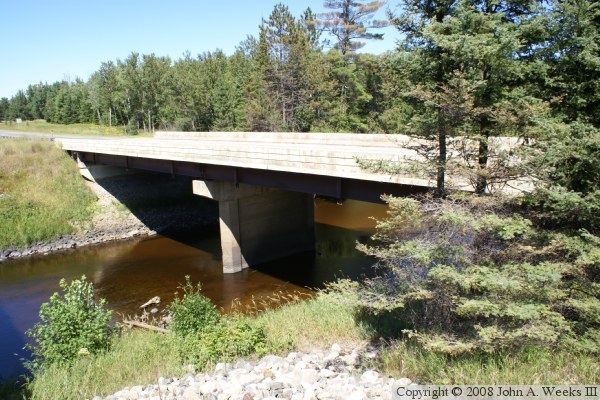
On this page, we look at the northbound US-53 bridge over the Saint Louis River. This is the original 2-way traffic lane of US-53, which became the northbound lanes when the new southbound lanes were added. The bridge appears to be a modern concrete deck bridge with modern style guardrails. Given that this is a 1953 era bridge, it is likely that the deck is not original and has been replaced, and the guardrails are recent modifications. The bridge is a steel girder bridge. That is likely due to this bridge being built before prestressed concrete girder bridges became common. The bridge has an unusual pier arrangement, with a single large pier sunk in the center of the river channel. Bridges of this side tend to have two piers, and tend to not place piers directly in the middle of the river channel.

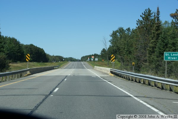
The photo above is looking north down the center of the northbound US-53 Bridge over the Saint Louis River from a vehicle traveling northbound.


US-53 Bridge (Northbound)
The photo above is looking northeast towards the downriver west face of the northbound US-53 Bridge. The vantage point is the top of the embankment on the south side of the river next to the southbound highway span. This photo is a bit overexposed due to the very dark area under the bridge. The photo below is a view looking northeast across the bridge deck from the southwest corner of the structure.

US-53 Bridge (Northbound)

Made With Macintosh
Authored by John A. Weeks III, Copyright © 1996—2016, all rights reserved.
For further information, contact: john@johnweeks.com