Current Weather Conditions
John A. Weeks III
Tuesday, March 19, 2024, 1:31:56 AM CDT
Home Photo Tours Rail Fan 12 Easy Steps
Aviation Spacecraft Highways & Bridges About The Author
 
Google Search
Maps   Groups   Images   Search
 
  Home
  • 12 Easy Steps
  • Aviation
  • Spacecraft
  • Highways & Bridges
    » Bridge Photography
      - MSP River Bridges
      - C & D Canal
      - Illinois River
      - Minnehaha Creek
      - Minnesota River
      - Mississippi River
      - Missouri River
      - St. Croix River
      - St. Louis River
        › St. Louis Headwaters
        › Upper St. Louis River
        › Forbes - US-53 Area
          · Town Line Road Br
          · US-53 Bridge (NB)
          · US-53 Bridge (SB)
          · Hawks Trail Bridge
          · DW&P RR Bridge
          · Evtac Road Bridge
          · Forbes Dam
          · CSAH-7 Bridge
          · DM&IR RR Forbes
        › Up Mid St. Louis River
        › Lw Mid St. Louis River
        › Fond du Lac Reservatn
        › Cloquet - Scanlon
        › Jay Cooke State Park
        › Twin Ports Harbor
      - Wisconsin River
      - Best Miss River Photos
      - Cable Stayed Bridges
      - McGilvray Road Bridges
      - I-35W Bridge Disaster
      - Miscellaneous Bridges
      - Madison County Bridges
      - Hist Br Weekend 2013
    » Road Geek Topics
  • Photo Tours
  • Rail Fan
  • About The Author
 
Site Search By JRank
Highways, Byways, And Bridge Photography
Hawks Trail Bridge
Saint Louis River Trail Crossing
Peary, MN

Hawks Trail Bridge

• Structure ID: N/A
• Location: River Mile 131.5
• River Elevation: 1,315 Feet
• Trail: Hawks Trail
• Daily Traffic Count: N/A
• Bridge Type: Steel Pony Truss, Wood Deck
• Bridge Length: 160 Feet (Estimated), 160 Foot Longest Span (Estimated)
• Bridge Width: 10 Feet (Estimated)
• Navigation Channel Width: Non-Navigable
• Height Above Water: 18 Feet
• Date Built: Sometime Between 2004 And 2007
This is the Saint Louis River crossing for Hawks Trail, a local snowmobile trail that runs along an old logging rail bed in central Saint Louis County. The trail was developed by a local snowmobile club. It is open to non-motorized use in the summer and fall, and reserved for snowmobiles in the winter. Hawks Trail is intended to be a gateway trail that runs from Duluth to Eveleth on the Iron Range. The last 4 mile gap in the train is planned to be open by the fall of 2010.

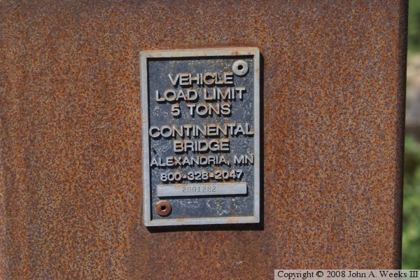
The bridge was built by Continental Bridge in Alexandria, Minnesota. Continental Bridge prefabricates a wide variety of bridge types and styles for pedestrian use, regional trails, industrial applications, and even small road bridges. The idea is to build the bridge in a factory in a controlled environment where workers have all the right tools, jigs, and materials. The finished bridge is delivered to the side, where it is erected in a single day. The mass customization process allows for a superior bridge to be built at a very competitive price. This bridge was reported to cost $250,000 including the site prep and installation.

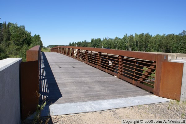
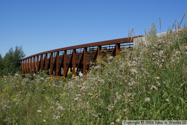
This style bridge is called the Connector Truss. It is good for spans of up to 200 feet. Longer spans are built in sections and joined with a field joint. Multiple spans can be joined with support piers to make even longer bridges. The truss can be flat or it can have a slight curve. The truss is formed by a top stringer and a bottom stringer. They are connected by vertical steel members. In addition, one angled brace is installed between each vertical member. There is an option for an X-brace, which results in a stronger truss, but the single brace is more than strong enough for a regional trail. The deck is built on cross members that are set about halfway between the top and bottom of the truss. This allows the top of the truss to be used as a guardrail, and the bottom of the truss has room for cross-bracing.

Unfortunately, there is no date stamped on this structure, and the bridge is not listed in the NBI, so I don't know exactly when it was built. These photos are from August, 2008, and the bridge had been in place at least a year at that point, which makes 2007 the latest date that it could have been built. The bridge does not appear on a 2004 aerial photo, so that sets a lower limit for the date. The serial number of the bridge is 2001282. This is a builder's serial number. It is possible that this truss span was built in 2001, and then sat in inventory at the factory until it was purchased for this project.

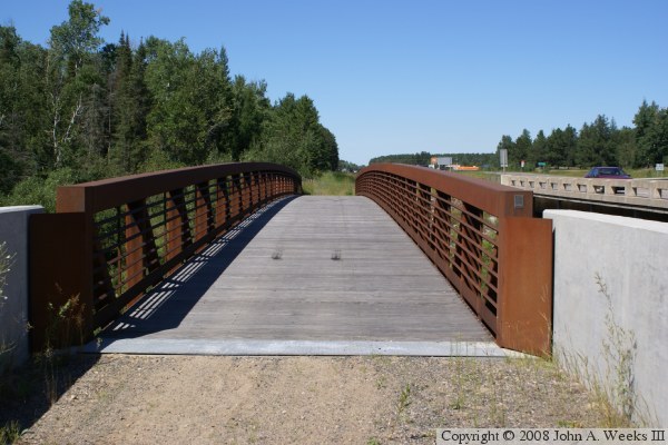
The photo above is looking north down the center of the bridge deck. The photo below is looking northeast across the bridge deck from the southwest corner of the structure. Highway US-53 is visible just east of this bridge.


Hawks Trail Bridge
Hawks Trail Bridge
The photo above is a view of the downriver west face of the truss span. The photo below is the bridge plate.

Hawks Trail Bridge

Made With Macintosh
Authored by John A. Weeks III, Copyright © 1996—2016, all rights reserved.
For further information, contact: john@johnweeks.com