Current Weather Conditions
John A. Weeks III
Thursday, September 2, 2010, 9:28:31 PM CDT
Home 12 Easy Steps Random Topics About The Author Portal
Aviation Spacecraft Highways & Bridges Photo Tours Rail Fan

Google Search

 Maps  Groups
 Images  Search
  Home
  • 12 Easy Steps
  • Aviation
  • Spacecraft
  • Highways & Bridges
    » Bridge Photography
      - MSP River Bridges
      - C & D Canal
      - Illinois River
      - Minnehaha Creek
      - Minnesota River
      - Mississippi River
        › Lake Itasca Area
          · Lake Itasca Dam
          · Log Bridge
          · Foot Bridge Hd Wtrs
          · Foot Bridge Vis Cen
          · Bicycle Path Bridge
          · Clrwater Co Hwy 117
          · MN-200 Bridge
          · Vekins Dam
          · Clrwater Co Hwy 37
          · Feil Bridge
          · Larson's Bridge
          · Larson's Culvert
          · Felt Bridge
          · Clrwater Co Hwy 40
          · Coffee Pot Landing
          · Hubbard Co 510th St
          · Beltrami Co Hwy 5
          · Bear Den Landing Br
        › Bemidji Area
        › Cass Lake - Ball Club
        › Grand Rapids Area
        › Blackberry - Crosby
        › Brainerd Lakes Area
        › Little Falls Area
        › St. Cloud Area
        › North Metro Area
        › Port Of Minneapolis
        › St. Anthony Falls Area
        › Mississippi Rvr Gorge
        › St. Paul Area
        › S St. Paul - Hastings
        › Red Wing - Winona
        › La Crosse Area
        › Lansing - Clinton
        › Quad Cities Area
        › Muscatine - Louisiana
        › St. Louis Area
        › Chester - Cairo
        › Miss - Tenn - Ark
        › Ark - Miss - Louisiana
        › Louisiana Structures
      - Missouri River
      - St. Croix River
      - St. Louis River
      - Wisconsin River
      - Cable Stayed Bridges
      - McGilvray Road
      - I-35W Bridge Disaster
      - Miscellaneous Bridges
    » Road Geek Topics
  • Random Topics
  • Photo Tours
  • Rail Fan
  • About The Author
  • John's Portal
 
Site Search By JRank
Highways, Byways, And Bridge Photography
Clearwater Co Highway 40
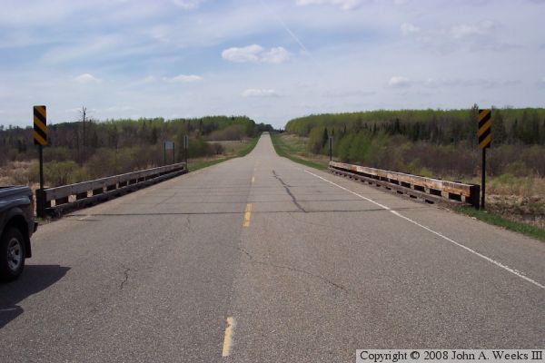
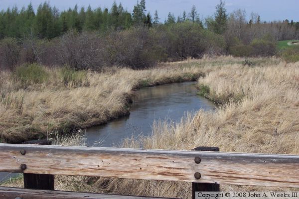
Mississippi River Highway Crossing
Near Itasca State Park, MN

Clearwater Co Highway 40

• Structure ID: NBI 15509
• Location: River Mile 1333.1
• River Elevation: 1,389 Feet
• County: Clearwater
• Highway: Clearwater County Highway 40
• Daily Traffic Count: 230 (2003)
• Bridge Type: Wood Trestle
• Bridge Length: 90 Feet, 30 Foot Longest Span
• Bridge Width: 32 Feet, 2 Lanes
• Height Above Water: 6 Feet
• Date Built: 1982
This is the second real highway bridge to cross the Mississippi River. It is a timber beam bridge, with metal poles sunk into the river bed to serve as piers for the structure. The bridge also has wood in the abutments it keeps the roadway fill from spilling back into the river channel.

Clearwater Co Highway 40
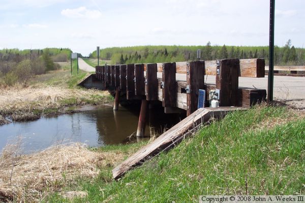
The photo above is a view of the side of the bridge. The photo below is a view from the bridge looking downriver (to the north). The photo at the top of the page is a view looking west across the bridge from the center of the highway.

Clearwater Co Highway 40

Made With Macintosh
Authored by John A. Weeks III, Copyright © 1996—2010, all rights reserved.
For further information, contact: john@johnweeks.com