Current Weather Conditions
John A. Weeks III
Monday, March 15, 2010, 7:34:32 PM CDT
Home 12 Easy Steps Random Topics About The Author Portal
Aviation Spacecraft Highways & Bridges Photo Tours Rail Fan

Google Search

 Maps  Groups
 Images  Search
  Home
  • 12 Easy Steps
  • Aviation
  • Spacecraft
  • Highways & Bridges
    » Bridge Photography
      - MSP River Bridges
      - Illinois River
      - Minnesota River
      - Mississippi River
        › Lake Itasca Area
        › Bemidji Area
        › Cass Lake - Ball Club
        › Grand Rapids Area
        › Blackberry - Crosby
        › Brainerd Lakes Area
        › Little Falls Area
        › St. Cloud Area
          · Champion Dam
          · City Bridge
          · Sartell Bridge
          · Bridge Of Hope
          · Sauk Rapids Bridge
          · Old Sauk Rapids Br
          · BNSF St. Cloud Br
          · Veterans Bridge
          · Granite City Crossing
          · Old DeSoto Bridge
          · University Bridge
          · St. Cloud Dam
          · Sportsman Island Br
          · Clearwater Bridge
        › North Metro Area
        › Port Of Minneapolis
        › St. Anthony Falls Area
        › Mississippi Rvr Gorge
        › St. Paul Area
        › S St. Paul - Hastings
        › Red Wing - Winona
        › La Crosse Area
        › Lansing - Clinton
        › Quad Cities Area
        › Muscatine - Louisiana
        › St. Louis Area
        › Chester - Cairo
        › Miss - Tenn - Ark
        › Ark - Miss - Louisiana
        › Louisiana Structures
      - Missouri River
      - St. Croix River
      - St. Louis River
      - Wisconsin River
      - Cable Stayed Bridges
      - McGilvray Road
      - I-35W Bridge Disaster
      - Miscellaneous Bridges
    » Road Geek Topics
  • Random Topics
  • Photo Tours
  • Rail Fan
  • About The Author
  • John's Portal
 
Site Search By JRank
Highways, Byways, And Bridge Photography
City Bridge
Mississippi River Utility Crossing
Sartell, MN

Sartell City Bridge

• Location: River Mile 932.4
• River Elevation: 993 Feet
• Counties: Benton, Stearns
• Structure: Pipeline Bridge
• Bridge Type: Steel Through Truss
• Bridge Length: 587 Feet, 135 Foot Longest Span
• Bridge Width: 28 Feet
• Height Above Water: 18 Feet
• Date Built: 1914
This 1914 bridge once carried automobile traffic across the river in the small town of Sartell, MN. The bridge turned out to be in an inconvenient location given the train tracks on the east side and the paper mill located on both sides of the road. Trucks had to be banned in the 1950s due to the weakness of the structure. The bridge was converted into a pedestrian bridge in 1984, but that proved to be awkward for the factory security, so the walkway was closed shortly after that. Today, the bridge carries utility pipes.

This is one of the last of the small steel through truss bridges that remains on the Mississippi River. Even if the bridge is no longer in use, one would hope that it is preserved for historical purposes.

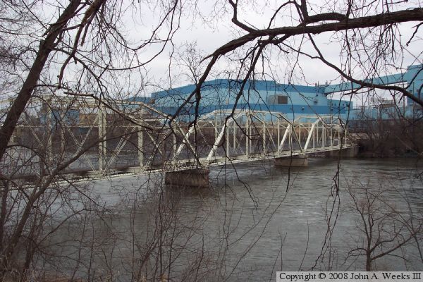
The photo above is a telephoto view of the center bridge span as seen from the nearby Sartell Bridge. The photo below is a view from a riverside parking lot located just upriver on the west side of the Mississippi.


Sartell City Bridge
Sartell City Bridge
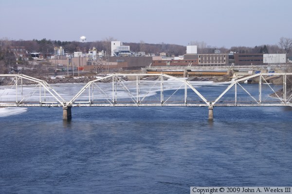
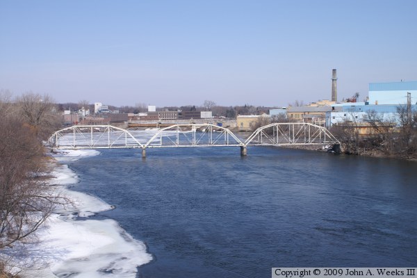
These two photos are views of the Sartell City Bridge as seen from the new Sartell Bridge located 800 feet downriver. The Champion Dam is located a further 950 feet upriver from the City Bridge. The photo above is a view looking slightly northeast, while the photo below is looking slightly northwest.

Sartell City Bridge
Sartell City Bridge
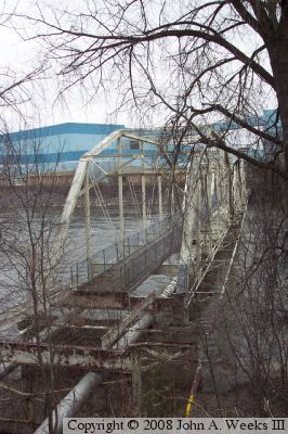
These two photos are views from the west river bank near the west abutment of the bridge. The photo above is a view of the downriver face of the bridge. The photo below is a view looking east down the length of the bridge deck from the southeast corner of the bridge. There is no direct access to the bridge. The pedestrian deck has been removed on the west end of the structure, but water mains still cross the old bridge. Trees have grown along the river, blocking any clear views of the structure from the west river bank, while access to the east river bank is restricted by the paper mill operators.
Sartell City Bridge

Made With Macintosh
Authored by John A. Weeks III, Copyright © 1996—2010, all rights reserved.
For further information, contact: john@johnweeks.com