Current Weather Conditions
John A. Weeks III
Friday, April 19, 2024, 4:30:13 PM CDT
Home Photo Tours Rail Fan 12 Easy Steps
Aviation Spacecraft Highways & Bridges About The Author
 
Google Search
Maps   Groups   Images   Search
 
  Home
  • 12 Easy Steps
  • Aviation
  • Spacecraft
  • Highways & Bridges
    » Bridge Photography
      - MSP River Bridges
      - C & D Canal
      - Illinois River
      - Minnehaha Creek
      - Minnesota River
      - Mississippi River
        › Lake Itasca Area
        › Bemidji Area
        › Cass Lake - Ball Club
        › Grand Rapids Area
        › Blackberry - Crosby
        › Brainerd Lakes Area
        › Little Falls Area
        › St. Cloud Area
        › North Metro Area
        › Port Of Minneapolis
        › St. Anthony Falls Area
          · WI Central RR Br
          · East Channel RR Br
          · Nicollet Island RR Br
          · First Avenue Bridge
          · East Channel Bridge
          · Father Louis Henn Br
          · Merriam Street Br
          · Third Avenue Bridge
          · U St Anthony F L&D
          · St Anthony Falls PP
          · St Anthony Falls Lab
          · Father Hennn Bluffs
          · Stone Arch Bridge
          · MPLS Eastern Trestle
          · Mill Ruins Park Br
          · Endless Bridge
          · Lower Bridge Ruins
          · Southeast Steam Plant
          · MPLS Western Bridge
          · L St Anthony F L&D
          · St Anthony Falls Br
          · I-35W Bridge (Old)
          · 10th Avenue Bridge
          · NP RR Bridge #9
        › Mississippi Rvr Gorge
        › St. Paul Area
        › S St. Paul - Hastings
        › Red Wing - Winona
        › La Crosse Area
        › Lansing - Clinton
        › Quad Cities Area
        › Muscatine - Louisiana
        › St. Louis Area
        › Chester - Cairo
        › Miss - Tenn - Ark
        › Ark - Miss - Louisiana
        › Louisiana Structures
      - Missouri River
      - St. Croix River
      - St. Louis River
      - Wisconsin River
      - Best Miss River Photos
      - Cable Stayed Bridges
      - McGilvray Road Bridges
      - I-35W Bridge Disaster
      - Miscellaneous Bridges
      - Madison County Bridges
      - Hist Br Weekend 2013
    » Road Geek Topics
  • Photo Tours
  • Rail Fan
  • About The Author
 
Site Search By JRank
Highways, Byways, And Bridge Photography
Merriam Street Bridge
Merriam Street Mississippi River Crossing
Minneapolis, MN

Merriam Street Bridge

• Structure ID: NBI: 27664.
• Location: River Mile 854.2.
• River Elevation: 801 Feet.
• Highway: Merriam Street.
• Daily Traffic Count: 1,077 (2001).
• Bridge Type: Steel Truss Through Deck.
• Length: 257 Feet.
• Width: 2 Traffic Lanes, 34 Feet.
• Navigation Channel Width: Non-Navigable.
• Height Above Water: 14 Feet.
• Date Built: 1987, Truss Span Dates To 1887.
This bridge started life back in 1887. It was one truss section of a 4 span truss bridge that crossed the Mississippi River at Broadway Avenue. The Broadway Avenue bridge was removed in 1985, and a new 4 lane bridge opened in 1987. The best of the 4 spans were picked to be saved. That span was floated down river, and installed across the East Channel of the Mississippi River in front of the Saint Anthony Main development.

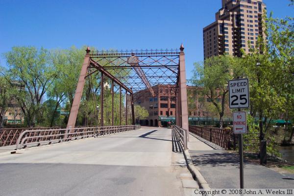
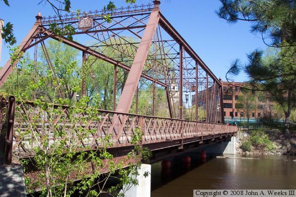
While the truss section dates from 1887, the piers and the approach spans for the Merriam Street Bridge are new construction. Due to concerns about the bridge structure, it was built on top of a set of steel girders. As a result, the truss no longer supports the main bridge span. Finally, the steel grate deck was removed and replaced with a concrete deck. Wooden walkways were built on the outside of the truss on each side of the bridge.

The bridge rebuilding work was very tastefully done. The bridge has the appearance of a 100 year old bridge, yet is built like a modern bridge. It looks very natural sitting at that location, like it was built to be there from the very start. This project is a very innovative reuse of an old bridge span.

The photo above is a view from the northeast corner of the bridge near Main Street, looking southwest across the east river channel towards Nicollet Island. The photo below is looking at the south bridge portal, looking across the bridge towards Saint Anthony Main.


Merriam Street Bridge
The photo above is view looking north across the Mississippi River from Nicollet Island along the east face of the Merriam Street Bridge. While the truss span dates from 1887, the piers and approach spans are new construction. The photo below is looking upstream to the west towards the east face of the structure from the westernmost tip of Water Power Park, which sits on an island just downstream of Nicollet Island.

Merriam Street Bridge

Made With Macintosh
Authored by John A. Weeks III, Copyright © 1996—2016, all rights reserved.
For further information, contact: john@johnweeks.com