Current Weather Conditions
John A. Weeks III
Thursday, April 18, 2024, 6:36:18 PM CDT
Home Photo Tours Rail Fan 12 Easy Steps
Aviation Spacecraft Highways & Bridges About The Author
 
Google Search
Maps   Groups   Images   Search
 
  Home
  • 12 Easy Steps
  • Aviation
  • Spacecraft
  • Highways & Bridges
    » Bridge Photography
      - MSP River Bridges
      - C & D Canal
      - Illinois River
      - Minnehaha Creek
      - Minnesota River
      - Mississippi River
        › Lake Itasca Area
        › Bemidji Area
        › Cass Lake - Ball Club
        › Grand Rapids Area
        › Blackberry - Crosby
        › Brainerd Lakes Area
        › Little Falls Area
        › St. Cloud Area
        › North Metro Area
        › Port Of Minneapolis
        › St. Anthony Falls Area
          · WI Central RR Br
          · East Channel RR Br
          · Nicollet Island RR Br
          · First Avenue Bridge
          · East Channel Bridge
          · Father Louis Henn Br
          · Merriam Street Br
          · Third Avenue Bridge
          · U St Anthony F L&D
          · St Anthony Falls PP
          · St Anthony Falls Lab
          · Father Hennn Bluffs
          · Stone Arch Bridge
          · MPLS Eastern Trestle
          · Mill Ruins Park Br
          · Endless Bridge
          · Lower Bridge Ruins
          · Southeast Steam Plant
          · MPLS Western Bridge
          · L St Anthony F L&D
          · St Anthony Falls Br
          · I-35W Bridge (Old)
          · 10th Avenue Bridge
          · NP RR Bridge #9
        › Mississippi Rvr Gorge
        › St. Paul Area
        › S St. Paul - Hastings
        › Red Wing - Winona
        › La Crosse Area
        › Lansing - Clinton
        › Quad Cities Area
        › Muscatine - Louisiana
        › St. Louis Area
        › Chester - Cairo
        › Miss - Tenn - Ark
        › Ark - Miss - Louisiana
        › Louisiana Structures
      - Missouri River
      - St. Croix River
      - St. Louis River
      - Wisconsin River
      - Best Miss River Photos
      - Cable Stayed Bridges
      - McGilvray Road Bridges
      - I-35W Bridge Disaster
      - Miscellaneous Bridges
      - Madison County Bridges
      - Hist Br Weekend 2013
    » Road Geek Topics
  • Photo Tours
  • Rail Fan
  • About The Author
 
Site Search By JRank
Highways, Byways, And Bridge Photography
Wisconsin Central Railroad Bridge
WC Railroad Mississippi River Crossing
Minneapolis, MN

Wisconsin Central Railroad Bridge

• Structure ID: NBI: 93835.
• Location: River Mile 854.5.
• River Elevation: 801 Feet.
• Railroad: Wisconsin Central Railroad.
• Bridge Type: Steel Truss Through Deck.
• Length: 175 Feet.
• Width: Single Track, 19 Feet.
• Navigation Channel Width: Non-Navigable.
• Height Above Water: 8 Feet (Estimated).
• Date Built: Opened 1901.
Boom Island was once a real island much like Nicollet Island is today. The island was used by lumber mills as the anchor-point for a large log boom operation on the Mississippi River. The boom would catch the logs that were floated downriver, and workers would sort of the logs sending them into pens for each of the various sawmills.

By the turn of the century, Boom Island was cleared and used as a storage yard by the sawmills. They needed large open spaces to stack green lumber to allow it to season. The Wisconsin Central Railroad purchased the lower half of Boom Island, and developed a large railroad yard. The track that connected this yard to the rail network split off of the Great Northern bridge over the east channel behind Nicollet Island. The branch line skirted along the northern edge of Nicollet Island, and then used this bridge to cross the Mississippi River east channel to reach Boom Island.

The railroad operation on Boom Island was in high gear until after WWII, where rail traffic in general started its downhill trend. The activity was very slow in the 1960s, leading to the railroad yards on Boom Island being cleared in the early 1970s.

This was good timing because there was an interstate highway building boom going on, and I-335 was proposed to cross the Mississippi River at Boom Island. As a result, the city purchased Boom Island. The upper section was cleaned up and built out as a regional park complete with a marina and boat launch. The lower section was tied up in the I-335 lawsuits, which took more than 20 years to settle. In the end, I-335 was canceled. The lower section of Boom Island sat vacant for many years. The area was finally cleaned up and developed into park area in the late 2000s.

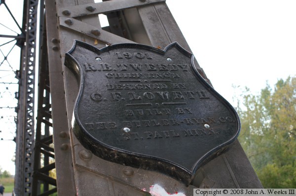
With all the changes in this area, it is amazing that this small bridge was able to survive. Perhaps that is due to its location. It sits in a low spot that is hard to see from either Nicollet Island or the north river bank. Perhaps being located in an out-of-the-way spot helped save this structure. In any event, the Minneapolis Park and Recreation Board obtained title to this bridge and refurbished it as a pedestrian and bicycle trail in 1987.

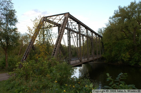
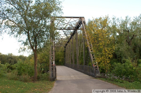
The photo above is a view of the west portal of the Wisconsin Central Railroad Bridge. The extensive brush and trees make the bridge a bit hard to locate, and even harder to photograph.


Wisconsin Central Railroad Bridge
The photo above is the bridge plate. The date, designer, engineer, and builder names are clearly visible. Notice that the plate is mounted with theft-resistant hardware. If not protected in this manner, these bridge plates tend to disappear. The photo below is a view of the west portal of the bridge.

Wisconsin Central Railroad Bridge
The photo above is a view of the south side of the bridge taken from the west bank of the river. The photo below is a view of the north side of the bridge taken from the west bank of the river.

Wisconsin Central Railroad Bridge
These two photos, we are looking across the main channel of the Mississippi River and into the east channel of the river. Nicollet Island is to the right, while Boom Island is to the left. These photos were taken from a parking area on West River Parkway. This is a view that I discovered only after the leaves fell off of the trees and some brush was cut along the river.

Wisconsin Central Railroad Bridge

Made With Macintosh
Authored by John A. Weeks III, Copyright © 1996—2016, all rights reserved.
For further information, contact: john@johnweeks.com