Current Weather Conditions
John A. Weeks III
Thursday, September 2, 2010, 8:56:53 PM CDT
Home 12 Easy Steps Random Topics About The Author Portal
Aviation Spacecraft Highways & Bridges Photo Tours Rail Fan

Google Search

 Maps  Groups
 Images  Search
  Home
  • 12 Easy Steps
  • Aviation
  • Spacecraft
  • Highways & Bridges
    » Bridge Photography
      - MSP River Bridges
      - C & D Canal
      - Illinois River
      - Minnehaha Creek
      - Minnesota River
      - Mississippi River
        › Lake Itasca Area
        › Bemidji Area
        › Cass Lake - Ball Club
        › Grand Rapids Area
        › Blackberry - Crosby
        › Brainerd Lakes Area
        › Little Falls Area
        › St. Cloud Area
        › North Metro Area
        › Port Of Minneapolis
        › St. Anthony Falls Area
        › Mississippi Rvr Gorge
        › St. Paul Area
        › S St. Paul - Hastings
        › Red Wing - Winona
        › La Crosse Area
        › Lansing - Clinton
        › Quad Cities Area
        › Muscatine - Louisiana
        › St. Louis Area
        › Chester - Cairo
        › Miss - Tenn - Ark
        › Ark - Miss - Louisiana
          · Helena Bridge
          · Charles W. Dean Br
          · Ben G Humphreys Br
          · Greenville Bridge
          · Old Vicksburg Bridge
          · Vicksburg Bridge
          · Natchez-Vidalia Br
          · Old River Control
        › Louisiana Structures
      - Missouri River
      - St. Croix River
      - St. Louis River
      - Wisconsin River
      - Cable Stayed Bridges
      - McGilvray Road
      - I-35W Bridge Disaster
      - Miscellaneous Bridges
    » Road Geek Topics
  • Random Topics
  • Photo Tours
  • Rail Fan
  • About The Author
  • John's Portal
 
Site Search By JRank
Highways, Byways, And Bridge Photography
Future Charles W. Dean Bridge
Future I-69 Mississippi River Crossing At Arkansas City
Arkansas City, Arkansas

Charles W. Dean Bridge

• Structure ID: N/A.
• Location: River Mile 566 (Estimated).
• River Elevation: 102 Feet.
• Highway: Future I-69
• Bridge Type: Cable Stayed Suspended Deck.
• Length: 4.25 Miles Overall, 1,500 Foot Main Span.
• Width: 4 Traffic Lanes Plus Shoulders
• Navigation Channel Width: 1,200 Foot Clear Channel (Estimated).
• Height Above Water: 85 Feet (Estimated).
• Date Built: 2010 Projected Opening.
Interstate highway I-69 is the proposed NAFTA highway connecting Canada (via Port Huron, Michigan) with Mexico (via Laredo, Texas). While a section of I-69 currently exists in Michigan and Indiana, the proposed extensions through High Priority Corridors 18 and 20 would make it one of the longest interstate highways in the United States.

A key design decision for the I-69 project is where to cross the Mississippi River. A number of alternatives were looked at. One popular idea was to cross just north and west of Memphis, providing another river crossing for the Memphis area. It was later decided to stay on the east side of the river through Memphis, and cross somewhere in Mississippi. At the same time, the people of Greenville wanted a new bridge to replace the existing sub-standard US-82 bridge. They were afraid that if the new Great River Bridge was built, they would never get a new US-82 crossing.

In the end, a new bridge at Greenville was funded, while I-69 continues to move forward more slowly. As of 2005, the new US-82 crossing in Greenville is about 60% complete. The Great River Bridge is now known as the Charles W. Dean Bridge (named after one of the early engineers on the project). The final location of the bridge will be between Benoit, Mississippi, and Arkansas City, Arkansas. As of 2009, the bridge has been approved by Congress for funding, but has not actually been funded yet. The state of Arkansas began to purchase land for the bridge starting in October, 2006.

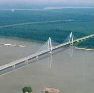
The two images on this page are renderings prepared for the design study. They show a very large cable stayed bridge with a 1,500 foot clear span flanked by over 4 miles of elevated highway. The rendering above is a view looking to the north. The photo below is looking northeast. The main span is located very close to the Mississippi side of the great river due to the navigation channel being along the east shore of the river.


Charles W. Dean  Bridge

Made With Macintosh
Authored by John A. Weeks III, Copyright © 1996—2010, all rights reserved.
For further information, contact: john@johnweeks.com