| Highways, Byways, And Bridge Photography |
Benjamin G. Humphreys Bridge
Former US-82 Mississippi River Crossing At Greenville
Greenville, Mississippi
|
• Structure ID: |
NBI: 0000000000M1536. |
|
• Location: |
River Mile 531.3. |
|
• River Elevation: |
92 Feet. |
|
• Highway: |
US-82. |
|
• Daily Traffic Count: |
7,200 (2002). |
|
• Bridge Type: |
Continuous Steel Truss Through Deck. |
|
• Length: |
9,957 Feet Overall, 840 Foot Longest Clear Span. |
|
• Width: |
24 Feet, 2 Lanes. |
|
• Navigation Channel Width: |
800 Feet. |
|
• Height Above Water: |
130 Feet. |
|
• Date Built: |
Opened October 1940, Closed August 4, 2010. |
The Mississippi River would often change paths before the great river was
tamed by the US Army Corps of Engineering. Once such change in the 1930s
suddenly left the river city of Greenville, Mississippi, about 7 miles from
the river. Following that event, the City of Natchez started working on a
new river bridge. A bit of political maneuvering found the same set of
blueprints being used to build a new river bridge over the new river channel
just west of Greenville.
The Benjamin G. Humphreys Bridge opened late in 1940. It soon became apparent
that the bridge was a navigation hazard. It turns out that there is a very
swift cross-current where the bridge is located. Riverboat operators have to
round a sharp bend, then aim for one of the bridge piers, with the current
pushing the head of the barge tow away from the pier at the last second. This
is something that only highly experienced river pilots can attempt, and it is
something that has gone wrong with deadly consequences a number of times.
Replacing the bridge became more of a matter of safety than a structural
issue.
An interesting design feature of the bridge are the arms that extend from the
upriver side of the bridge. They carry electrical and communications lines
across the river. Normally, those lines would be buried in trenches in the
riverbed. But due to the fast current, the lines were repeatedly uncovered and
snagged by anchor lines. The revenue from leasing space for these utilities
allowed the toll to be removed from the bridge in 1950.
Another interesting fact about this bridge is that it is almost entirely in
Arkansas, including most of the east approach to the bridge. The state line
between Arkansas and Mississippi was established to be the center of the main
channel of the river. Over the years, the river has changed course several
times in this area. At the bridge site, the river has scoured a channel
that moved west several thousand feet. As a result, both ends of the
bridge are in Arkansas, and only the easternmost piers of the approach
road are located in Mississippi. This was the only bridge on the lower
Mississippi River where the state line boundary does not follow the current
main river channel. The new cable stayed Greenville Bridge built just
downstream now shares this same geographical quirk.
Ben Humphreys was a member of the US House of Representatives, elected
in 1902. He fought for flood control on the lower Mississippi, a fight
that was largely in vain until after the massive flood of 1912. He is
regarded as the father of flood control in the delta region.
A project to replace the Benjamin G. Humphreys bridge started in 2001. The
new bridge was planned to be a giant cable stayed structure, one of the
largest in North America. The new bridge was completed in 2006, but both
Arkansas and Mississippi had difficulty funding the approach spans. As a
result, the new bridge was completed, but with 100 foot drop-offs at each
end, being the classic bridge to nowhere. Each state finally did fund their
approach spans, with Mississippi being complete in 2008 and Arkansas being
complete in 2009. However, the projects to tie the new approaches into the
old highway were even later. The Mississippi side was completed in 2010,
but the Arkansas side is still under construction as this was written in 2011.
A temporary cross-over was built on the Arkansas side, allowing traffic to
be shifted onto the new Greenville Bridge on August 4, 2010.
Once the new bridge was opened, work started on dismantling the old bridge.
Work started on the trestle spans on the east side of the Mississippi River.
Many spans were removed with cranes, however, the last span leading to the
truss spans was dropped using explosives. The center of the main bridge
span was disconnected and lowered onto barges using strand jacks (cables
suspended from the bridge). When I visited the site in early September of
2011, the east and west truss spans were still standing, as was the trestle
spans on the west side of the Mississippi River.
The Humphreys Bridge was the scene of a 1953 airplane crash. A jet pilot
from nearby Greenville Air Force Base attempted to fly under the bridge.
He missed. The aircraft was a total loss, the pilot was fatally injured,
and the bridge suffered $175,000 in damage. The clipping below was sent
to me by Virginia Flesher, whose husband was stationed at the air base
when this accident happened. In fact, I had originally repeated an often
misreported date of 1951, which I was happy to finally be able to correct.

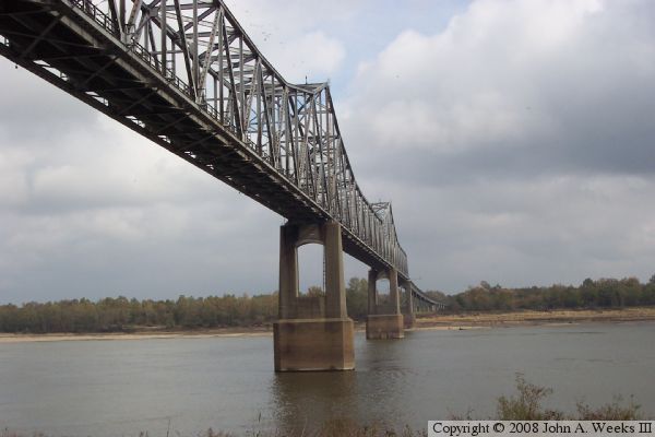
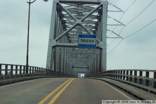
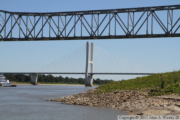
The photo at the top of the page is the downriver face of the Humphreys Bridge
as seen from the riverbank on the west side of the Mississippi River. The
far shore is the state of Mississippi. The photo below is the upriver
face of the bridge as seen from a side road on the Arkansas side of the
great river.
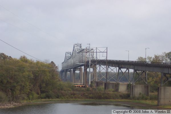

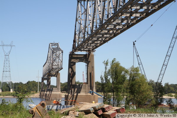
The photo above is the truss superstructure as seen from a parking area
located under the bridge on the Arkansas side of the Mississippi River.
This parking area is being used by the crew building the new cable stay
bridge just downriver. The photo below is looking west from the same
location at the approach span heading into Arkansas.

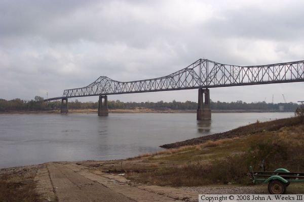
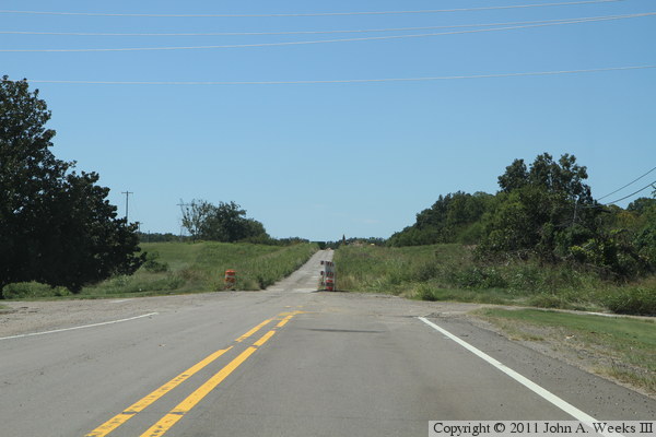
The photo above is looking southeast from a boat ramp located upstream
of the Arkansas side of the bridge. The photo below is the first photo
of a three photo set showing a typical river crossing heading westbound
towards Arkansas. This photo is a view traveling on the relatively level
section of the approach spans on the far east end of the structure.

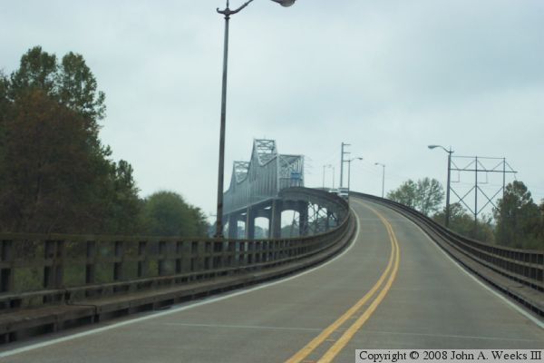
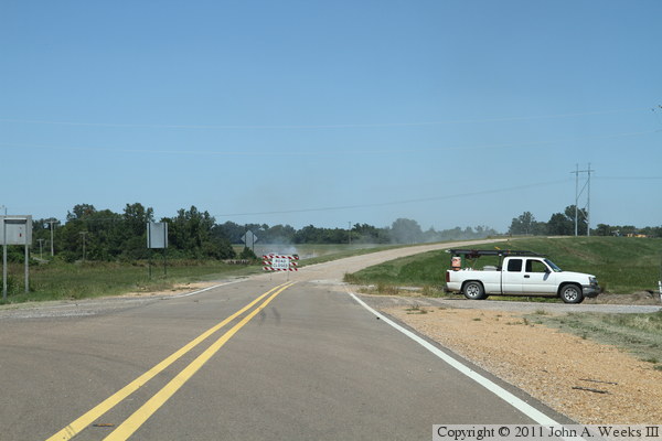
These two photos are the final two photos of a three photo set showing a
typical bridge crossing heading westbound into Arkansas. The photo above
is the transition between the relatively level approach spans to the ramp
heading up to the truss spans. Note that this photo shows that the truss
spans are absolutely level. The photo above is entering the east portal
of the truss spans. Note the power lines attached to the north side of
the truss.
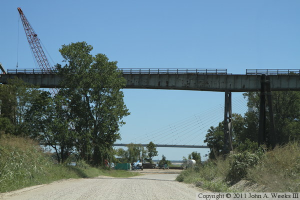
The photo above is the end of the line for old highway US-82. The old
right of way still serves Harlow's Casino, Resort, and Hotel, but ends
at the west side of the casino property. A single lane haul road leads
up to the location of the abutment of the trestle section of the old
bridge. The trestle has been removed on the east side of the Mississippi
River when this photo was taken in early September, 2011. The photo below
is the west approach to the structure. While the road is closed, crews are
still using the approach to support the demolition. The bridge abutment is
located near the power poles.
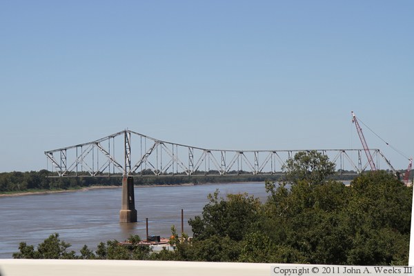
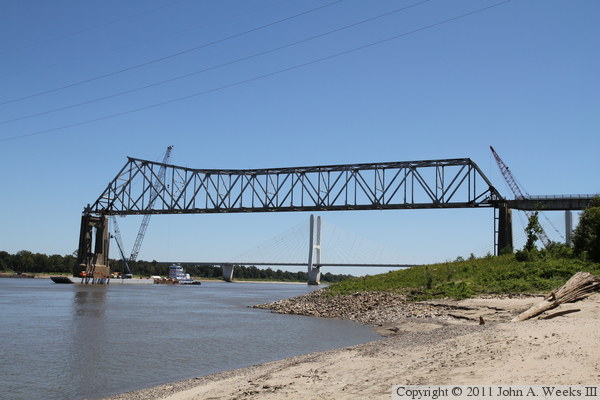
These two photos are looking upstream from the deck of the new Greenville
Bridge. I shot several other photos of the old bridge while crossing the new
bridge, but the camera autofocus locked onto the bridge guard rail, rendering
the bridge out of focus. The photo above is the eastern of the truss spans,
while the photo below shows the western span and the gap over the navigation
channel.


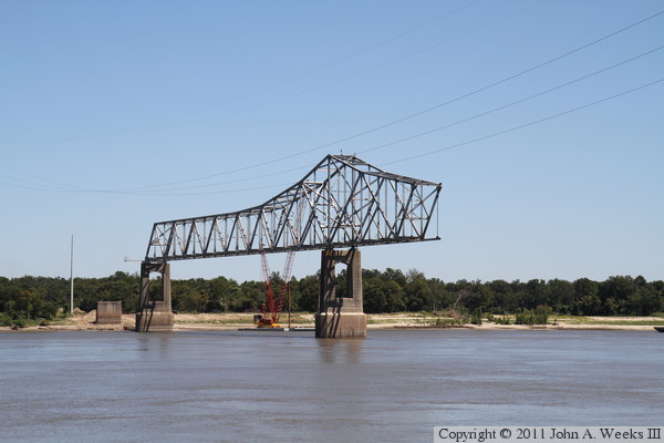
These are two views of the Benjamin G. Humphreys bridge main truss span being
dismantled. The photo above is the first span on the west side of the
Mississippi River, while the photo below shows the first span on the east
side of the river. The main navigation channel span has already been removed.
These two photos are additional views of the main truss spans being
dismantled. The photo above is the span on the east side of the river,
while the photo below is the span on the west side of the river. The vantage
point is a boat landing located just upstream of the bridge site on the west
bank of the Mississippi River. I suspect that the east span will be trimmed
back similar to the west span, and then explosives will be used to drop the
spans off the piers.
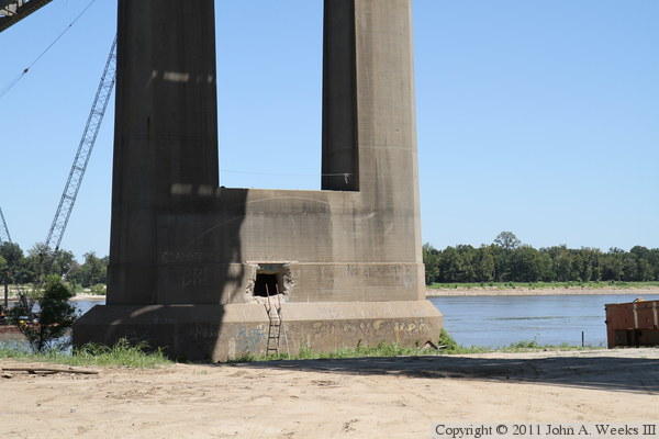
The photo above is the base of the west main bridge pier. A hole has been
drilled into the tower base, likely to provide a path for inspectors to gain
access to the interior of the pier for planning an explosive demolition.
The photo above is the east main bridge tower of the new Greenville Bridge,
located 2,750 feet downstream of the old bridge.
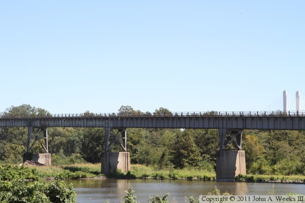
The photo above is the last deck plate girder trestle span leading up to the
main truss span. It crosses an access road leading to a grain terminal, and
the staging area for the Greenville Bridge project. The photo below is the
deck plate girder trestle on the west side of the Mississippi River as it
crosses over a slough.
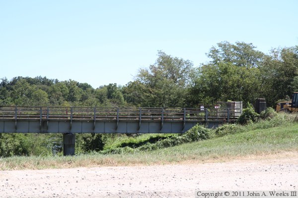
The photo above is the west bridge abutment. The photo below is a culvert
passing through the approach to the west bridge abutment.

|
