Current Weather Conditions
John A. Weeks III
Friday, December 1, 2023, 4:43:51 AM CST
Home Photo Tours Rail Fan 12 Easy Steps
Aviation Spacecraft Highways & Bridges About The Author
 
Google Search
Maps   Groups   Images   Search
 
  Home
  • 12 Easy Steps
  • Aviation
  • Spacecraft
  • Highways & Bridges
    » Bridge Photography
      - MSP River Bridges
      - C & D Canal
      - Illinois River
      - Minnehaha Creek
      - Minnesota River
        › Ortonville - Odessa
        › Correll - Wegdahl
        › Granite Fls - Rdwd Fls
        › Morton - Judson
        › Mankato - Jordan
          · US-169 North Star
          · Veterans Memorial Br
          · US-14 Bridge
          · Omaha Bridge Ruins
          · MN-22 Bridge
          · Broadway Bridge
          · MN-93 Bridge
          · US-169 Bridge
          · MN-19 Bridge
          · Blakeley Bridge
          · MN-25 Bridge
          · Crvr Co 45 Scott Co 9
        › MSP West Metro
        › MSP South Metro
      - Mississippi River
      - Missouri River
      - St. Croix River
      - St. Louis River
      - Wisconsin River
      - Best Miss River Photos
      - Cable Stayed Bridges
      - McGilvray Road Bridges
      - I-35W Bridge Disaster
      - Miscellaneous Bridges
      - Madison County Bridges
      - Hist Br Weekend 2013
    » Road Geek Topics
  • Photo Tours
  • Rail Fan
  • About The Author
 
Site Search By JRank
Highways, Byways, And Bridge Photography
MN-93 Bridge
Minnesota River Highway Crossing
Le Sueur, MN

MN-93 Bridge

• Structure ID: NBI: 72007.
• Location: River Mile 82.0.
• River Elevation: 732 Feet.
• Highway: MN-93.
• Daily Traffic Count: 6,300 (2004).
• Bridge Type: Steel Girder, Concrete Deck.
• Length: 421 Feet.
• Width: 43 Feet.
• Navigation Channel Width: Non-Navigable.
• Height Above Water: 15 Feet (Estimated).
• Date Built: 1984.
The Minnesota River runs along the west side of the small city of Le Sueur, Minnesota. The main entrance to the city from the west is via MN-93, which crosses the Minnesota River as it enters the city. MN-93 was once the main route of US-169 between Henderson and Le Sueur, but that changed when the new 4-lane section of US-169 was built in 1960. This bridge replaces an earlier truss bridge at the same location.

While the MN-93 bridge is highly functional, there has been no attempt what-so-ever to dress up the bridge. It is about as run of the mill as a modern steel girder bridge can be. One interesting item is a sensor on the west end of the bridge for low clearance. That is interesting because there is no clearance problem on the bridge. It turns out that the sensor is not for the river bridge, but rather, for the Union Pacific railroad bridge over MN-93 on the east end of the river crossing. This railroad bridge is also rather narrow. Rather than building the highway bridge narrow to match, the highway bridge was built the proper width. This makes the bridge ready in the event that the railroad bridge is eventually replaced. In the mean time, a funky little guard rail sits at an angle to the edge of the bridge to protect the corner of the railroad bridge that extends close to the traffic lane.

Le Sueur is famous as the home of the Mayo family. Dr. William Worrall Mayo moved to Le Sueur in the mid 1850s. He established his first medical practice on Main Street. He later moved to Rochester with his two sons, William and Charles, where they established the world famous Mayo Clinic.

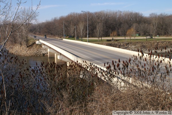
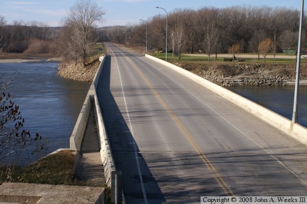
The photo above is looking west down the length of the MN-93 bridge. The angled guard rail protects the Union Pacific railroad bridge abutment. The vantage point is from the south end of the railroad bridge on the east bank of the Minnesota River. The photo below is looking southeast towards the downriver north face of the structure. The vantage point is a roadside park and boat landing on the west bank of the river.


MN-93 Bridge
MN-93 Bridge
The photo above is looking northwest towards the upriver side of the MN-93 bridge. The vantage point is the Union Pacific railroad track on the east bank of the river just south of the highway. The photo below is a view of the traffic deck while traveling eastbound on MN-93 towards the city of Le Sueur.

MN-93 Bridge
MN-93 Bridge
These two photos are views from the spring flood in 2010. The photo above shows the upriver south side of the bridge, while the photo below shows the downriver north side of the bridge. The steel girders under the bridge were acting as a dam holding back the flow of the river. As a result, the water moved around the bridge and poured over the highway leading to the west end of the structure.

MN-93 Bridge
MN-93 Bridge
These two photos are additional views from the flood of 2010. The photo above is the bridge deck as seen from the Union Pacific Railroad overpass at the east end of the river crossing. The photo below is a closer view of the west end of the bridge. Notice the water flowing over the road and cascading down the right side of the highway.

MN-93 Bridge

Made With Macintosh
Authored by John A. Weeks III, Copyright © 1996—2016, all rights reserved.
For further information, contact: john@johnweeks.com