Current Weather Conditions
John A. Weeks III
Saturday, July 27, 2024, 8:45:38 AM CDT
Home Photo Tours Rail Fan 12 Easy Steps
Aviation Spacecraft Highways & Bridges About The Author
 
Google Search
Maps   Groups   Images   Search
 
  Home
  • 12 Easy Steps
  • Aviation
  • Spacecraft
  • Highways & Bridges
    » Bridge Photography
      - MSP River Bridges
      - C & D Canal
      - Illinois River
      - Minnehaha Creek
      - Minnesota River
      - Mississippi River
        › Lake Itasca Area
        › Bemidji Area
        › Cass Lake - Ball Club
        › Grand Rapids Area
        › Blackberry - Crosby
        › Brainerd Lakes Area
        › Little Falls Area
        › St. Cloud Area
        › North Metro Area
        › Port Of Minneapolis
        › St. Anthony Falls Area
        › Mississippi Rvr Gorge
        › St. Paul Area
        › S St. Paul - Hastings
        › Red Wing - Winona
        › La Crosse Area
        › Lansing - Clinton
          · Lock & Dam #8
          · Black Hawk Bridge
          · Big Slough Bridge
          · Stevens Slough Br
          · Henderson Slough Br
          · Winneshiek Slough Br
          · Lock & Dam #9
          · Washington Street
          · Blackhawk Avenue
          · Twin Suspension Br
          · Marquette-Joliet Br
          · East Channel Bridge
          · WI Street Bridge
          · Iowa Street Bridge
          · St. Feriole Is RR
          · Lock & Dam #10
          · Lock & Dam #11
          · Eagle Point Bridge
          · Dubuque-Wisconsin
          · City Island Bridge
          · 16th Street Bridge
          · CN RR Bridge
          · Julien Dubuque Br
          · Lock & Dam #12
          · Savanna-Sabula Br
          · Running Slough Br
          · Sabula Rail Bridge
          · Lock & Dam #13
          · Lyons-Fulton Bridge
          · Gateway Bridge
          · Sunfish Slough Br
          · C&NW Clinton Br
          · C&NW IL Ch RR
          · C&NW Sunfish Sl
        › Quad Cities Area
        › Muscatine - Louisiana
        › St. Louis Area
        › Chester - Cairo
        › Miss - Tenn - Ark
        › Ark - Miss - Louisiana
        › Louisiana Structures
      - Missouri River
      - St. Croix River
      - St. Louis River
      - Wisconsin River
      - Best Miss River Photos
      - Cable Stayed Bridges
      - McGilvray Road Bridges
      - I-35W Bridge Disaster
      - Miscellaneous Bridges
      - Madison County Bridges
      - Hist Br Weekend 2013
    » Road Geek Topics
  • Photo Tours
  • Rail Fan
  • About The Author
 
Site Search By JRank
Highways, Byways, And Bridge Photography
Washington Street Bridge
Washington Street Mississippi River Crossing At Prairie du Chien
Prairie du Chien, Wisconsin

Washington Street Bridge

• Structure ID: NBI P12070900000000.
• Location: River Mile 635.6.
• River Elevation: 611 Feet.
• Highway: Washington Street.
• Daily Traffic Count: 1,100 (2001).
• Bridge Type: Steel Girder, Concrete Deck.
• Length: 52 Feet Overall, 52 Foot Longest Span.
• Width: 30 Feet, 2 Lanes.
• Navigation Channel Width: Non-Navigable.
• Height Above Water: 10 Feet (Estimated).
• Date Built: Opened 1961.
The settlement at Prairie du Chien began on the island of Saint Feriole, an island on the Wisconsin side of the Mississippi River. Due to repeated major floods, the island today is mostly a city park and historical site, and the city is on the mainland.

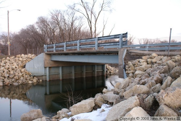
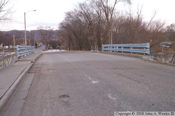
During the years that the city was mostly on the island, a crossing to the mainland to the east was needed. Many bridges were installed over the years, and all but this last one were washed out. In fact, this bridge was built when the previous bridge was destroyed in the 1960 flood. The earliest bridge at this location, an 1837 structure suffered a similar fate, as did its replacement, built in 1839.

Washington Street Bridge

Made With Macintosh
Authored by John A. Weeks III, Copyright © 1996—2016, all rights reserved.
For further information, contact: john@johnweeks.com