Current Weather Conditions
John A. Weeks III
Sunday, March 14, 2010, 6:58:33 PM CDT
Home 12 Easy Steps Random Topics About The Author Portal
Aviation Spacecraft Highways & Bridges Photo Tours Rail Fan

Google Search

 Maps  Groups
 Images  Search
  Home
  • 12 Easy Steps
  • Aviation
  • Spacecraft
  • Highways & Bridges
    » Bridge Photography
      - MSP River Bridges
      - Illinois River
      - Minnesota River
      - Mississippi River
        › Lake Itasca Area
        › Bemidji Area
        › Cass Lake - Ball Club
        › Grand Rapids Area
        › Blackberry - Crosby
        › Brainerd Lakes Area
        › Little Falls Area
        › St. Cloud Area
        › North Metro Area
        › Port Of Minneapolis
        › St. Anthony Falls Area
        › Mississippi Rvr Gorge
        › St. Paul Area
        › S St. Paul - Hastings
        › Red Wing - Winona
        › La Crosse Area
        › Lansing - Clinton
          · Lock & Dam #8
          · Black Hawk Bridge
          · Big Slough Bridge
          · Stevens Slough Br
          · Henderson Slough Br
          · Winneshiek Slough Br
          · Lock & Dam #9
          · Washington Street
          · Blackhawk Avenue
          · Twin Suspension Br
          · Marquette-Joliet Br
          · East Channel Bridge
          · WI Street Bridge
          · Iowa Street Bridge
          · St. Feriole Is RR
          · Lock & Dam #10
          · Lock & Dam #11
          · Eagle Point Bridge
          · Dubuque-Wisconsin
          · City Island Bridge
          · 16th Street Bridge
          · CN RR Bridge
          · Julien Dubuque Br
          · Lock & Dam #12
          · Savanna-Sabula Br
          · Running Slough Br
          · Sabula Rail Bridge
          · Lock & Dam #13
          · Lyons-Fulton Bridge
          · Gateway Bridge
          · Sunfish Slough Br
          · C&NW Clinton Br
          · C&NW IL Ch RR
          · C&NW Sunfish Sl
        › Quad Cities Area
        › Muscatine - Louisiana
        › St. Louis Area
        › Chester - Cairo
        › Miss - Tenn - Ark
        › Ark - Miss - Louisiana
        › Louisiana Structures
      - Missouri River
      - St. Croix River
      - St. Louis River
      - Wisconsin River
      - Cable Stayed Bridges
      - McGilvray Road
      - I-35W Bridge Disaster
      - Miscellaneous Bridges
    » Road Geek Topics
  • Random Topics
  • Photo Tours
  • Rail Fan
  • About The Author
  • John's Portal
 
Site Search By JRank
Highways, Byways, And Bridge Photography
Lyons-Fulton Bridge
IA-136/IL-136 Mississippi River Crossing At Clinton
Clinton, Iowa

Lyons-Fulton Bridge

• Structure ID: NBI 000000000021055 (IA), 000098990819611 (IL).
• Location: River Mile 520.0.
• River Elevation: 572 Feet.
• Highway: IA-136, IL-136.
• Daily Traffic Count: 11,400 (2003).
• Bridge Type: Steel Truss Through Deck.
• Length: 3,011 Feet, 500 Foot Longest Span.
• Width: 30 Feet, 2 Lanes.
• Navigation Channel Width: 450 Feet.
• Height Above Water: 65 Feet.
• Date Built: Opened January 1975.
While this bridge looks like a much older design, it was built in fairly recent times. Bridges are rarely being built with these large superstructures. Rather, if it were built today, it would likely have been built as a cable stayed bridge. It would also have been built with wider lanes, shoulders, a center divider, and a bicycle path if it had been built in the last decade.

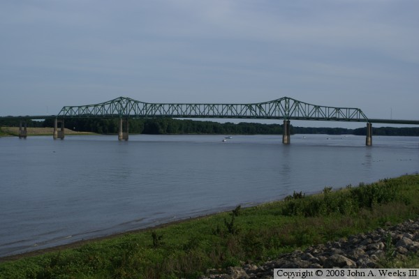
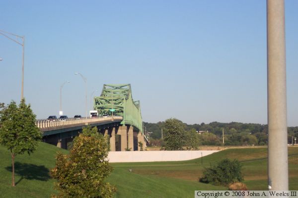
This bridge replaced a much older and more famous Lyons-Fulton Bridge that was located a mile or two upstream. The older bridge was once part of the Lincoln Highway, and once carried US-30. US-30 now follows an alignment that takes it to the south side of Clinton.


Lyons-Fulton  Bridge

Made With Macintosh
Authored by John A. Weeks III, Copyright © 1996—2010, all rights reserved.
For further information, contact: john@johnweeks.com