Current Weather Conditions
John A. Weeks III
Thursday, September 2, 2010, 8:25:03 PM CDT
Home 12 Easy Steps Random Topics About The Author Portal
Aviation Spacecraft Highways & Bridges Photo Tours Rail Fan

Google Search

 Maps  Groups
 Images  Search
  Home
  • 12 Easy Steps
  • Aviation
  • Spacecraft
  • Highways & Bridges
    » Bridge Photography
      - MSP River Bridges
      - C & D Canal
      - Illinois River
      - Minnehaha Creek
      - Minnesota River
      - Mississippi River
        › Lake Itasca Area
        › Bemidji Area
        › Cass Lake - Ball Club
        › Grand Rapids Area
        › Blackberry - Crosby
        › Brainerd Lakes Area
        › Little Falls Area
        › St. Cloud Area
        › North Metro Area
        › Port Of Minneapolis
        › St. Anthony Falls Area
        › Mississippi Rvr Gorge
        › St. Paul Area
        › S St. Paul - Hastings
        › Red Wing - Winona
        › La Crosse Area
        › Lansing - Clinton
          · Lock & Dam #8
          · Black Hawk Bridge
          · Big Slough Bridge
          · Stevens Slough Br
          · Henderson Slough Br
          · Winneshiek Slough Br
          · Lock & Dam #9
          · Washington Street
          · Blackhawk Avenue
          · Twin Suspension Br
          · Marquette-Joliet Br
          · East Channel Bridge
          · WI Street Bridge
          · Iowa Street Bridge
          · St. Feriole Is RR
          · Lock & Dam #10
          · Lock & Dam #11
          · Eagle Point Bridge
          · Dubuque-Wisconsin
          · City Island Bridge
          · 16th Street Bridge
          · CN RR Bridge
          · Julien Dubuque Br
          · Lock & Dam #12
          · Savanna-Sabula Br
          · Running Slough Br
          · Sabula Rail Bridge
          · Lock & Dam #13
          · Lyons-Fulton Bridge
          · Gateway Bridge
          · Sunfish Slough Br
          · C&NW Clinton Br
          · C&NW IL Ch RR
          · C&NW Sunfish Sl
        › Quad Cities Area
        › Muscatine - Louisiana
        › St. Louis Area
        › Chester - Cairo
        › Miss - Tenn - Ark
        › Ark - Miss - Louisiana
        › Louisiana Structures
      - Missouri River
      - St. Croix River
      - St. Louis River
      - Wisconsin River
      - Cable Stayed Bridges
      - McGilvray Road
      - I-35W Bridge Disaster
      - Miscellaneous Bridges
    » Road Geek Topics
  • Random Topics
  • Photo Tours
  • Rail Fan
  • About The Author
  • John's Portal
 
Site Search By JRank
Highways, Byways, And Bridge Photography
Winneshiek Slough Bridge
IA-9/WI-82 Mississippi River Crossing At Lansing
Lansing, Iowa

Winneshiek Slough Bridge

• Structure ID: NBI B12000500000000.
• Location: River Mile 663.4.
• River Elevation: 620 Feet.
• Highway: IA-9, WI-82
• Daily Traffic Count: 2,357 (2003).
• Bridge Type: Steel Truss Top Deck.
• Length: 639 Feet, 170 Foot Longest Span.
• Width: 26 Feet, 2 Lanes.
• Navigation Channel Width: 164 Feet.
• Height Above Water: 13 Feet.
• Date Built: Opened 1956.
The Mississippi River crossing at Lansing, Wisconsin, consists of the main channel Blackhawk Bridge, and four smaller bridges. This page focuses on the fifth bridge from Iowa, the first on the Wisconsin side of the crossing. Like the other smaller bridges in this crossing, the original 1931 wooden structure was destroyed on March 18, 1945 by heavy ice. The crossing sat idle until it was purchased by the states of Iowa and Wisconsin in 1953, the bridges rebuilt, and opened to the public again in 1957.

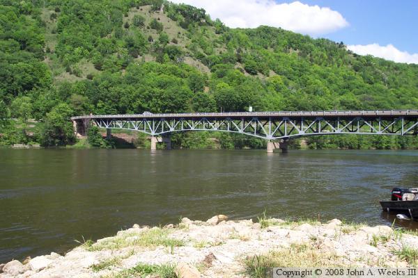
The Winneshiek Slough bridge features a top deck configuration where the roadway is sitting on top of a metal truss structure. The bridge has a very interesting sub-structure in comparison to the otherwise ordinary roadway segment.


Winneshiek Slough Bridge

Made With Macintosh
Authored by John A. Weeks III, Copyright © 1996—2010, all rights reserved.
For further information, contact: john@johnweeks.com