Current Weather Conditions
John A. Weeks III
Thursday, March 18, 2010, 6:58:05 AM CDT
Home 12 Easy Steps Random Topics About The Author Portal
Aviation Spacecraft Highways & Bridges Photo Tours Rail Fan

Google Search

 Maps  Groups
 Images  Search
  Home
  • 12 Easy Steps
  • Aviation
  • Spacecraft
  • Highways & Bridges
    » Bridge Photography
      - MSP River Bridges
      - Illinois River
      - Minnesota River
      - Mississippi River
        › Lake Itasca Area
        › Bemidji Area
        › Cass Lake - Ball Club
        › Grand Rapids Area
        › Blackberry - Crosby
        › Brainerd Lakes Area
        › Little Falls Area
        › St. Cloud Area
        › North Metro Area
        › Port Of Minneapolis
        › St. Anthony Falls Area
        › Mississippi Rvr Gorge
        › St. Paul Area
        › S St. Paul - Hastings
        › Red Wing - Winona
        › La Crosse Area
        › Lansing - Clinton
        › Quad Cities Area
          · Fred Schwengel Mem
          · Le Claire Canal
          · Smith's Island Foot
          · LD #14 Entrance Br
          · Lock & Dam #14
          · Campbell's Island Br
          · Iowa-Illinois Mem Br
          · Moline-Arsenal Br
          · Sylvan Slough Canal
          · Moline Power Plant
          · Sylvan Island RR
          · Sylvan Island Wagon
          · Sylvan Slough RR
          · Arsenal Power Plant
          · Sylvan Slough Via
          · Government Bridge
          · Lock & Dam #15
          · Centennial Bridge
          · Crescent RR Br
          · Sgt. John F. Baker Br
        › Muscatine - Louisiana
        › St. Louis Area
        › Chester - Cairo
        › Miss - Tenn - Ark
        › Ark - Miss - Louisiana
        › Louisiana Structures
      - Missouri River
      - St. Croix River
      - St. Louis River
      - Wisconsin River
      - Cable Stayed Bridges
      - McGilvray Road
      - I-35W Bridge Disaster
      - Miscellaneous Bridges
    » Road Geek Topics
  • Random Topics
  • Photo Tours
  • Rail Fan
  • About The Author
  • John's Portal
 
Site Search By JRank
Highways, Byways, And Bridge Photography
Lock & Dam #14 Bridge
Mississippi River Crossing At Pleasant Valley
Pleasant Valley, Iowa

Lock & Dam #14 Bridge

• Structure ID:
• Location: River Mile 493.1.
• River Elevation: 572 Feet.
• Highway: Lock & Dam #14 Entrance.
• Daily Traffic Count: Unknown.
• Bridge Type: Pratt Truss Steel Deck.
• Length: 78 Feet Overall.
• Width: Unknown.
• Navigation Channel Width: 78 Feet.
• Height Above Water: 7 Feet.
• Date Built: Unknown.
The first major structure at this location is the auxiliary lock, which was built as part of the US Army Corps of Engineers 6-foot navigation channel. A canal was built around the west side of Smith's Island and around a major rapids on the Mississippi River to feed this lock. When the 9-foot navigation channel was built, a new lock and dam was built across the main channel of the river, submerging the rapids forever.

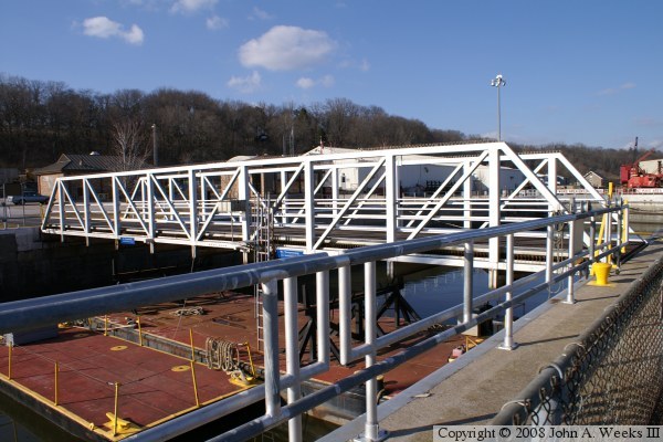
The problem is that there was no way to get vehicles out to the area where the new lock and dam was built. The solution is a temporary bridge, which is placed across the auxiliary lock during the months of low recreational boat traffic. When the lock is needed, the barge in the lock simply lifts the bridge, and floats it away for storage. The bottom photo shows the bridge tender barge, and the black brackets that make up the lifting mechanism.


Lock & Dam #14 Bridge

Made With Macintosh
Authored by John A. Weeks III, Copyright © 1996—2010, all rights reserved.
For further information, contact: john@johnweeks.com