Current Weather Conditions
John A. Weeks III
Monday, March 15, 2010, 12:14:28 AM CDT
Home 12 Easy Steps Random Topics About The Author Portal
Aviation Spacecraft Highways & Bridges Photo Tours Rail Fan

Google Search

 Maps  Groups
 Images  Search
  Home
  • 12 Easy Steps
  • Aviation
  • Spacecraft
  • Highways & Bridges
    » Bridge Photography
      - MSP River Bridges
      - Illinois River
      - Minnesota River
      - Mississippi River
        › Lake Itasca Area
        › Bemidji Area
        › Cass Lake - Ball Club
        › Grand Rapids Area
        › Blackberry - Crosby
        › Brainerd Lakes Area
        › Little Falls Area
        › St. Cloud Area
        › North Metro Area
        › Port Of Minneapolis
        › St. Anthony Falls Area
        › Mississippi Rvr Gorge
        › St. Paul Area
        › S St. Paul - Hastings
        › Red Wing - Winona
        › La Crosse Area
        › Lansing - Clinton
        › Quad Cities Area
          · Fred Schwengel Mem
          · Le Claire Canal
          · Smith's Island Foot
          · LD #14 Entrance Br
          · Lock & Dam #14
          · Campbell's Island Br
          · Iowa-Illinois Mem Br
          · Moline-Arsenal Br
          · Sylvan Slough Canal
          · Moline Power Plant
          · Sylvan Island RR
          · Sylvan Island Wagon
          · Sylvan Slough RR
          · Arsenal Power Plant
          · Sylvan Slough Via
          · Government Bridge
          · Lock & Dam #15
          · Centennial Bridge
          · Crescent RR Br
          · Sgt. John F. Baker Br
        › Muscatine - Louisiana
        › St. Louis Area
        › Chester - Cairo
        › Miss - Tenn - Ark
        › Ark - Miss - Louisiana
        › Louisiana Structures
      - Missouri River
      - St. Croix River
      - St. Louis River
      - Wisconsin River
      - Cable Stayed Bridges
      - McGilvray Road
      - I-35W Bridge Disaster
      - Miscellaneous Bridges
    » Road Geek Topics
  • Random Topics
  • Photo Tours
  • Rail Fan
  • About The Author
  • John's Portal
 
Site Search By JRank
Highways, Byways, And Bridge Photography
Crescent Railroad Bridge
BNSF Mississippi River Crossing At Davenport
Davenport, Iowa

Crescent Railroad Bridge

• Structure ID:
• Location: River Mile 481.4.
• River Elevation: 545 Feet.
• Railroad: Burlington Northern Santa Fe Railroad.
• Daily Traffic Count: 2 Trains Per Day (Estimated).
• Bridge Type: Steel Truss Through Deck w/Swing Span.
• Length: 2,383 Feet Overall, 442 Foot Swing Span.
• Width: 1 Track.
• Navigation Channel Width: 198.3 Feet (Illinois Channel), 197.9 Feet (Iowa Channel).
• Height Above Water:: 26 Feet.
• Date Built: Opened January 8, 1900.
Bridge is called the Crescent Bridge due to its curved shape. The hump back bridge sections and the swing span form a straight line. But the three smaller flat top bridge sections form an arc to allow the bridge to meet up with the railroad that runs parallel to the river on the Illinois side without that railroad taking up a lot of space by making a big loop.

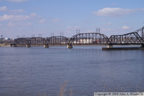
Bridge was built by the Rock Island Bridge And Terminal Company. The Davenport, Rock Island, and Northwestern Railroad took control of the bridge in 1901, where it was jointly owned by the Chicago, Burlington, and Quincy and the Milwaukee Road. In 1995, Canadian Pacific (the former Soo Line) took over the Milwaukee Road, taking the Iowa side track. The Burlington Northern ended up with the bridge and the Illinois track, which became the BNSF when the BN merged with the Santa Fe Railroad.


Crescent Railroad Bridge

Made With Macintosh
Authored by John A. Weeks III, Copyright © 1996—2010, all rights reserved.
For further information, contact: john@johnweeks.com