Current Weather Conditions
John A. Weeks III
Sunday, October 1, 2023, 8:03:38 PM CDT
Home Photo Tours Rail Fan 12 Easy Steps
Aviation Spacecraft Highways & Bridges About The Author
 
Google Search
Maps   Groups   Images   Search
 
  Home
  • 12 Easy Steps
  • Aviation
  • Spacecraft
  • Highways & Bridges
    » Bridge Photography
      - MSP River Bridges
      - C & D Canal
      - Illinois River
      - Minnehaha Creek
      - Minnesota River
      - Mississippi River
      - Missouri River
      - St. Croix River
      - St. Louis River
        › St. Louis Headwaters
        › Upper St. Louis River
        › Forbes - US-53 Area
        › Up Mid St. Louis River
        › Lw Mid St. Louis River
        › Fond du Lac Reservatn
        › Cloquet - Scanlon
          · Knife Falls Boom Site
          · Upper Dunlap Is (Old)
          · Upper Dunlap Is Br
          · Cloquet Bridge Ruins
          · Main Street Br (Old)
          · Main Street Bridge
          · MN-33 Br (N Span)
          · MN-33 Br (S Span)
          · Lower Dunlap Is Br
          · Knife Falls Dam
          · Cloquet Dam
          · Lk Superior Pipeline
          · Scanlon Dam
          · CSAH-61 Bridge
          · I-35 Bridges
        › Jay Cooke State Park
        › Twin Ports Harbor
      - Wisconsin River
      - Best Miss River Photos
      - Cable Stayed Bridges
      - McGilvray Road Bridges
      - I-35W Bridge Disaster
      - Miscellaneous Bridges
      - Madison County Bridges
      - Hist Br Weekend 2013
    » Road Geek Topics
  • Photo Tours
  • Rail Fan
  • About The Author
 
Site Search By JRank
Highways, Byways, And Bridge Photography
MN-33 Bridge (North Channel)
MN-33 Saint Louis River Highway Crossing
Cloquet, MN

MN-33 Bridge (North Channel)

• Structure ID: NBI 09008
• Location: River Mile 36.2
• River Elevation: 1,179 Feet
• Highways: MN-33
• Daily Traffic Count: 13,200 (2004)
• Bridge Type: Prestressed Concrete Girder, Concrete Deck
• Bridge Length: 528 Feet, 133 Foot Longest Span
• Bridge Width: 76 Feet, 4 Lanes
• Navigation Channel Width: Non-Navigable
• Height Above Water: ??? Feet
• Date Built: 1995
There are two bridges that make up the MN-33 Saint Louis River crossing in Cloquet. One bridge is a high bridge, the other is a low bridge near to the water. While the two bridges appear to be different, they are actually very similar in both engineering and their decorative elements.

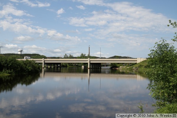
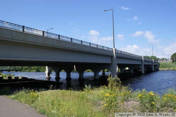
While the southern bridge in this crossing is tall and has a number of spans, the northern bridge over the north channel of the Saint Louis River is low to the water and has 4 equal length spans. The bridge is low to the water because the river is not navigable at this location and there is no need to span over streets or railroad tracks.

Despite being low and short as compared to long and tall, this bridge has the same decorative elements as the southern bridge in this river crossing. That includes various vertical lines and horizontal inserts cast into the concrete. The piers have arch-shaped openings below the deck, and the ends of the piers extend above the deck and form the anchors for the guardrails. A modern style street light was selected where the arm of the light is flat and sits at a perfect right angle from the support pole. The railings consist of a standard height concrete guardrail, topped off by a wrought-iron railings. These upper rails are not only very attractive looking, they act as protection for bicyclist.

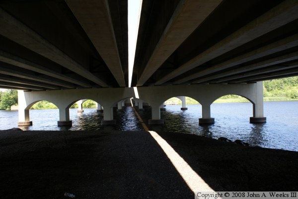
One interesting detail that we see under the bridge is that the bridge was built as two independent roadways joined by a single pier that carries both roadways. We can tell that there is a gap between roadways by the beam of sunlight running the length of the bridge on the surface of the river.

The photo above is looking north along the downriver east face of the MN-33 Bridge over the north channel of the Saint Louis River. The vantage point is a walking trail on Dunlap Island. The Upper Dunlap Island Bridge, a former railroad bridge now used as a recreational trail, is visible in the distance on the far left side of the photograph.


MN-33 Bridge (North Channel)
The photo above is looking west towards the east face of the MN-33 Bridge over the north channel. The vantage point is an access road that runs along the north side of the Saint Louis River towards the Knife Falls Dam power substation. The photo below is looking east downriver towards the west face of the MN-33 Bridge. The vantage point is a walking trail in Riverfront Park. The Sappi Paper Mill (formerly Potlatch) can be seen in the distance.

MN-33 Bridge (North Channel)
These two photos are views traveling northbound across the MN-33 river crossing. The photo above is a view traveling down the grade from the taller south channel bridge, while the photo below is a view entering the south end of the north channel bridge.

MN-33 Bridge (North Channel)
The photo above is looking down the east face of the MN-33 north channel bridge from the edge of the river channel on Dunlap Island. The photo below is a view looking north from under the bridge. The bright white line is sunlight passing between a small gap between the two bridge decks.

MN-33 Bridge (North Channel)

Made With Macintosh
Authored by John A. Weeks III, Copyright © 1996—2016, all rights reserved.
For further information, contact: john@johnweeks.com