Current Weather Conditions
John A. Weeks III
Sunday, May 5, 2024, 1:58:24 PM CDT
Home Photo Tours Rail Fan 12 Easy Steps
Aviation Spacecraft Highways & Bridges About The Author
 
Google Search
Maps   Groups   Images   Search
 
  Home
  • 12 Easy Steps
  • Aviation
  • Spacecraft
  • Highways & Bridges
    » Bridge Photography
      - MSP River Bridges
      - C & D Canal
      - Illinois River
      - Minnehaha Creek
      - Minnesota River
      - Mississippi River
        › Lake Itasca Area
        › Bemidji Area
        › Cass Lake - Ball Club
        › Grand Rapids Area
        › Blackberry - Crosby
        › Brainerd Lakes Area
        › Little Falls Area
        › St. Cloud Area
        › North Metro Area
        › Port Of Minneapolis
        › St. Anthony Falls Area
        › Mississippi Rvr Gorge
        › St. Paul Area
        › S St. Paul - Hastings
        › Red Wing - Winona
        › La Crosse Area
        › Lansing - Clinton
          · Lock & Dam #8
          · Black Hawk Bridge
          · Big Slough Bridge
          · Stevens Slough Br
          · Henderson Slough Br
          · Winneshiek Slough Br
          · Lock & Dam #9
          · Washington Street
          · Blackhawk Avenue
          · Twin Suspension Br
          · Marquette-Joliet Br
          · East Channel Bridge
          · WI Street Bridge
          · Iowa Street Bridge
          · St. Feriole Is RR
          · Lock & Dam #10
          · Lock & Dam #11
          · Eagle Point Bridge
          · Dubuque-Wisconsin
          · City Island Bridge
          · 16th Street Bridge
          · CN RR Bridge
          · Julien Dubuque Br
          · Lock & Dam #12
          · Savanna-Sabula Br
          · Running Slough Br
          · Sabula Rail Bridge
          · Lock & Dam #13
          · Lyons-Fulton Bridge
          · Gateway Bridge
          · Sunfish Slough Br
          · C&NW Clinton Br
          · C&NW IL Ch RR
          · C&NW Sunfish Sl
        › Quad Cities Area
        › Muscatine - Louisiana
        › St. Louis Area
        › Chester - Cairo
        › Miss - Tenn - Ark
        › Ark - Miss - Louisiana
        › Louisiana Structures
      - Missouri River
      - St. Croix River
      - St. Louis River
      - Wisconsin River
      - Best Miss River Photos
      - Cable Stayed Bridges
      - McGilvray Road Bridges
      - I-35W Bridge Disaster
      - Miscellaneous Bridges
      - Madison County Bridges
      - Hist Br Weekend 2013
    » Road Geek Topics
  • Photo Tours
  • Rail Fan
  • About The Author
 
Site Search By JRank
Highways, Byways, And Bridge Photography
East Channel Bridge
US-18 Mississippi River Crossing At Prairie du Chien
Prairie du Chien, Wisconsin

East Channel Bridge

• Structure ID: NBI B12002800000000.
• Location: River Mile 634.8.
• River Elevation: 611 Feet.
• Highway: US-18.
• Daily Traffic Count: 5,200 (2001).
• Bridge Type: Steel Girder, Concrete Deck.
• Length: 1,916 Feet Overall, 350 Foot Longest Span.
• Width: 40 Feet, 2 Lanes.
• Navigation Channel Width: 340 Feet.
• Height Above Water: 60 Feet.
• Date Built: Opened June 1975.
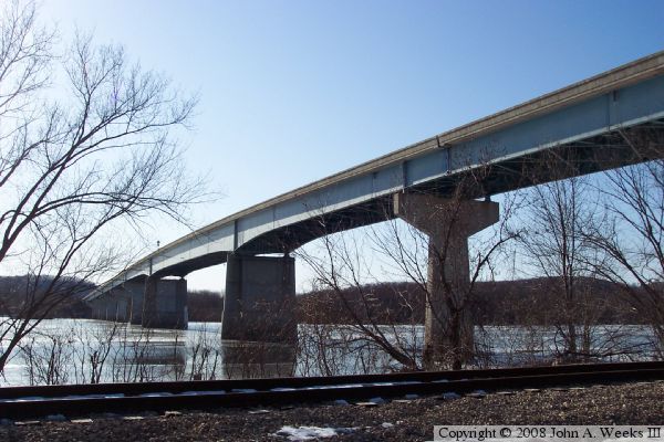
East Channel Bridge is part of the Mississippi River crossing at Prairie du Chien. The structure is a conventional steel girder bridge with a concrete deck. It was built in 1975 along with the Marquette-Joliet Bridge over the main river channel. The east channel is actually wider than the main channel, but the east channel is used only by light craft, the navigation channel does not need to be as high or wide as the navigation channel of the Marquette-Joliet Bridge. Notice that the piers are T-shaped, except for the two center channel piers. This feature serves to mark the navigation channel.

East Channel Bridge
East Channel Bridge

Made With Macintosh
Authored by John A. Weeks III, Copyright © 1996—2016, all rights reserved.
For further information, contact: john@johnweeks.com