Current Weather Conditions
John A. Weeks III
Sunday, May 12, 2024, 4:07:32 PM CDT
Home Photo Tours Rail Fan 12 Easy Steps
Aviation Spacecraft Highways & Bridges About The Author
 
Google Search
Maps   Groups   Images   Search
 
  Home
  • 12 Easy Steps
  • Aviation
  • Spacecraft
  • Highways & Bridges
    » Bridge Photography
      - MSP River Bridges
      - C & D Canal
      - Illinois River
      - Minnehaha Creek
      - Minnesota River
      - Mississippi River
        › Lake Itasca Area
        › Bemidji Area
        › Cass Lake - Ball Club
        › Grand Rapids Area
        › Blackberry - Crosby
        › Brainerd Lakes Area
        › Little Falls Area
        › St. Cloud Area
        › North Metro Area
        › Port Of Minneapolis
        › St. Anthony Falls Area
        › Mississippi Rvr Gorge
        › St. Paul Area
        › S St. Paul - Hastings
        › Red Wing - Winona
        › La Crosse Area
        › Lansing - Clinton
        › Quad Cities Area
          · Fred Schwengel Mem
          · Le Claire Canal
          · Smith's Island Foot
          · LD #14 Entrance Br
          · Lock & Dam #14
          · Campbell's Island Br
          · Iowa-Illinois Mem Br
          · Moline-Arsenal Br
          · Sylvan Slough Canal
          · Moline Power Plant
          · Sylvan Island RR
          · Sylvan Island Wagon
          · Sylvan Slough RR
          · Arsenal Power Plant
          · Sylvan Slough Via
          · Government Bridge
          · Lock & Dam #15
          · Centennial Bridge
          · Crescent RR Br
          · Sgt. John F. Baker Br
        › Muscatine - Louisiana
        › St. Louis Area
        › Chester - Cairo
        › Miss - Tenn - Ark
        › Ark - Miss - Louisiana
        › Louisiana Structures
      - Missouri River
      - St. Croix River
      - St. Louis River
      - Wisconsin River
      - Best Miss River Photos
      - Cable Stayed Bridges
      - McGilvray Road Bridges
      - I-35W Bridge Disaster
      - Miscellaneous Bridges
      - Madison County Bridges
      - Hist Br Weekend 2013
    » Road Geek Topics
  • Photo Tours
  • Rail Fan
  • About The Author
 
Site Search By JRank
Highways, Byways, And Bridge Photography
Lock & Dam #15
Mississippi River Lock & Dam
Rock Island, Illinois

Lock & Dam #15

• Structure: Lock & Dam #15.
• Location: River Mile 482.7.
• Dam Width: 1,203 Feet Overall.
• River Elevation (Pool): 561 Feet.
• River Elevation (Outflow): 546 Feet.
• Water Fall: 15 Feet.
• Annual Lock Traffic: 5,552 Vessels, 20,991,000 Tons (2005).
• Date Opened: March 7, 1934.
The Quad Cities area was known to river boat pilots as 13 miles of dangerous rapids during high water, and 13 miles of impossible rapids during low water. The US Army Corps of Engineers worked to clear the snags and build wing dams, but that was more of a band aid than a solution to the rapids.

The first attempt to solve the navigation problem involved building a canal and lock around the worst of the rapids upstream near the present day Lock & Dam #14. That was built for the 6-foot navigation project. While a modern dam with 9-foot locks have been built at that site, the canal and 6-foot lock is still in use for pleasure craft.

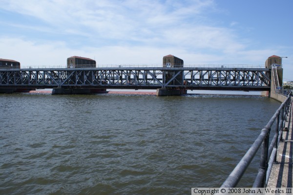
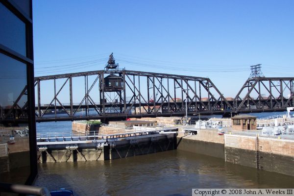
After World War I, technology lead to larger river boats that required a deeper draft. Congress funded the 9-foot navigation project. This project required that the Le Claire lock and dam be upgraded from a 6-foot structure to a 9-foot structure. At the same time, a second 9-foot structure would be required only a few miles downstream. The site that was picked was between Davenport and Rock Island, at the foot of Arsenal Island. Construction was tricky because the double deck Government rail and road bridge crossed the site. In fact, that bridge had a swing section to allow river traffic to pass. That swing section was located between the two locks, and would swing to be parallel with the center wall between the locks. This allowed both locks to be clear for traffic to enter and exit while the swing span was open.

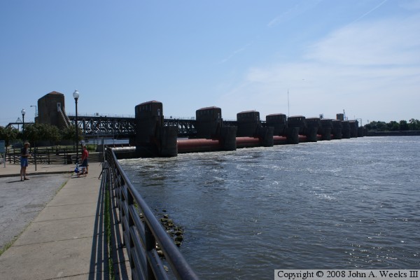
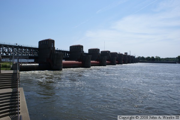
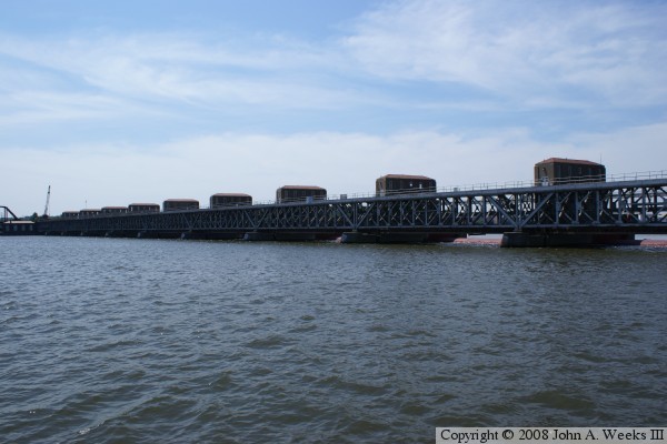
The dam is built with 11 gates. The gates are hollow metal tubes that can be lowered into the water to block the river flow. Each gate is 109 feet wide. This is reported to be the largest dam in the world made exclusively from roller gates. These roller gates were new technology in the late 1920s. In fact, the US Army stole the technology from Germany after WWI. Most other locks and dams on the great river use a combination of roller gates and Tainter gates.


Lock & Dam #15
Lock & Dam #15
Lock & Dam #15
Lock & Dam #15

Made With Macintosh
Authored by John A. Weeks III, Copyright © 1996—2016, all rights reserved.
For further information, contact: john@johnweeks.com