While these rail lines provided access to Duluth, they did not provide the Northern Pacific with a route to the docks in Duluth. As iron ore became a major industry, the Northern Pacific built a large ore dock on the south end of Superior near the Superior Entry channel out to Lake Superior. The route to this dock branched off of the mainline at Carlton, looped south of the Saint Louis River, crossed into Wisconsin, and headed northeast directly to the ore dock.
These rail lines gave the Northern pacific access to both Duluth and Superior, but did not allow trains to easily cross between the two sides of the harbor. To solve this problem, the Northern Pacific built two bridges across the Saint Louis River. The first is the Grassy Point Drawbridge. It crosses the river and bay directly east and west near to the present day US-2 Bong Bridge. The swing span for the Grassy Point Drawbridge is visible next to the Bong Bridge when heading southbound on US-2. The other bridge across Saint Louis Bay was built very near to the US-53 Blatnik Bridge. However, the Great Northern Railroad was there first, and they picked the best location across Saint Louis Bay between Connors Point and Rices Point.
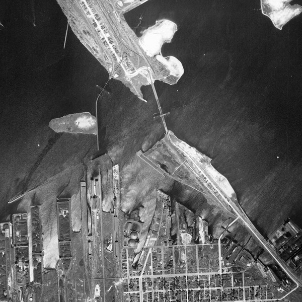
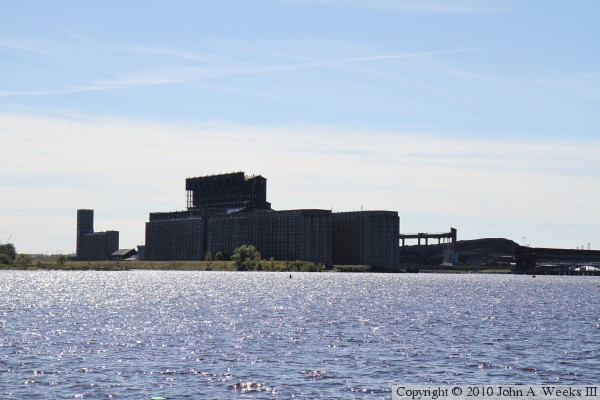
The Northern Pacific had to make do with a less ideal location to cross Saint Louis Bay. The route that was selected exited Superior to the north along the grain elevators that are visible to the west of the Blatnik Bridge. These are the present day Burlington Northern Santa Fe grain elevators. The bridge exited Duluth from the railroad yard on the east side of Rices Point. This is the rail yard that is just east of I-535 on the north end of the Blatnik Bridge. There is a significant problem with this path across the bay, and that is that it crosses two different navigation channels. The north channel provides access to docks on the Duluth side of the bay, including the massive Duluth, Missabe, and Iron Range ore docks. The south channel provides access to the docks on the north side of Superior, including the grain docks and the former Soo Line ore docks. The net result is that this crossing of the Saint Louis Bay would require two main channel spans. Since this is a railroad bridge, a tall span is not an option. That would mean building lift spans or swing spans. Swing spans were more common at the time. Two spans would mean twice the complexity, twice as much machinery, and two bridge operators.
The Saint Louis Bay bridge was built as a double-track structure. It left Rices Point heading southwest. It crossed a short truss span, then crossed the swing span over the north navigation channel. This swing span was known as the Minnesota Draw. The bridge then crossed a low trestle, turning due south and running along a small island in the bay that is commonly referred to as Bird Island. The trestle passed the island, crossed the south navigation channel on a swing span, then landed on the east side of a man-made peninsula that was built for a large grain elevator. The southern swing span was known as the Wisconsin Draw. I estimate that the bridge was 3,400 feet over water, plus another 1,200 feet on the peninsula.
The beginning of the end of the Saint Louis Bay bridge happened with the 1970 merger of the Great Northern, Northern Pacific, and the Chicago, Burlington, and Quincy to form the Burlington Northern Railroad. Ore traffic had dropped and the rail yards on Rices Point and along downtown Duluth had lost their importance. The Great Northern had already abandoned the Interstate Bridge in 1962. The BN still had two bridges over the harbor. Since the Saint Louis Bay Bridge sat in an awkward location and was expensive to operate, the BN decided to focus on the Grassy Point Bridge.
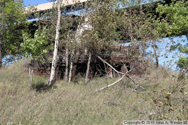
There are no visible remains of the Saint Louis Bay bridge. The land on the Duluth end is currently in use by a sand and gravel operation. Harbor navigation maps do warn of submerged bridge ruins along the path of the trestle. Since the bridge was removed, the navigation channels have been dredged to make them wider and deeper.
The bridge was reported to have been removed in the summer of 1986. I moved to Duluth for College in June of 1987, and I recall that it was still standing at that time. I don't recall specifically when it disappeared. I also have not learned when it was built or when it was abandoned. I would appreciate it very much if someone could help me fill in these details, and perhaps provide a photo of the bridge.
The photo above is a postcard from the first half of the 20th century. This image started as a drawing or painting rather than a photograph. As a result, it is an artist impression of the scene rather than being a photographic documentation of the scene. The view is looking southeast from the top of the bluffs in West Duluth. The DM&IR ore docks are in the foreground. The grain elevators on the Superior side are on the top right, while the shipyards and Minnesota Point are on the top left. The Saint Louis Bay Bridge connects between Rices Point in Duluth to the grain elevator area on the Superior side of the bay. The Minnesota Draw swingspan is on the left, but is a little hard to spot in the image. The Wisconsin Draw swingspan is on the right. The swing bridge behind the Saint Louis Bay Bridge is the Great Northern Interstate Bridge.