The Oliver Bridge is the lessor known of the three highway bridges
between the Twin Ports cities of Duluth and Superior. It crosses
from the Gary and New Duluth neighborhoods of Duluth to the small
town of Oliver in Wisconsin. The Oliver Bridge is named after the
town of Oliver, which is in turn named after the Pittsburgh industrialist
Henry Oliver, who developed a large iron mine on the Iron Range in
Minnesota.
The Oliver Bridge was built as a swing span bridge. It had a long
metal trestle, with a 300 foot long swing span located near the
Wisconsin side of the bridge. A narrow two lane highway deck was
constructed under the railroad deck. Since there were large concrete
abutments on each end of the bridge, the highway deck had sharp 90
degree corners on each end of the bridge. For most of the life of
the bridge, the highway deck was made out of timber and wooden boards,
making the crossing very spooky. The rail deck once supported twin
tracks, but a section of the eastbound track has been removed at each
end of the bridge. This appears to have been done to allow more light
to shine on the very dark corners of the highway deck. The bridge was
closed in 2001 and 2002 to allow MN-DOT and Wi-DOT to work with DM&IR
to replace the highway deck with a concrete floor and guardrails.
While the Oliver Bridge was built as a swing span, there is no evidence
that it ever operated as a working swing bridge. The Duluth harbor was
never extended past the Gary New Duluth steel mills and furnace complex.
The river is not readily navigable beyond the bridge. The bridge was
opened in the 1960s as part of a pipeline project. It reportedly took
3 days of work to get the bridge open. Since work was done on the bridge
in 1970, it appears that it is no longer possible to open the swing span.
The bridge was owned for many years by the Duluth, Missabe, and Iron
Range Railroad. The DM&IR sold out to the Canadian National on
May 10, 2004, passing ownership of the Oliver Bridge to the CN. The
rail line served by this bridge acts as a southwest bypass for trains
around the Twin Ports area. A dozen different railroads have trackage
rights over the bridge, resulting in very heavy traffic. The bridge
currently hosts an average of 24 trains per day. Many of these trains
are unit trains hauling coal in from the Power River Basin in Wyoming.
Update — a gentleman whose father worked at the Fond du Lac power
station wrote to me stating that as a child, he rode on the Steamer
Montauk several times. The Montauk regularly made the 19 mile trip from
Duluth to Fond du Lac, operating from 1924 to 1939. Given that this was
a relatively large boat at 180 feet long, the bridge would have had to
open to let it pass. This would seem to answer the question that the
bridge did indeed operate as a functional swing span for many years.
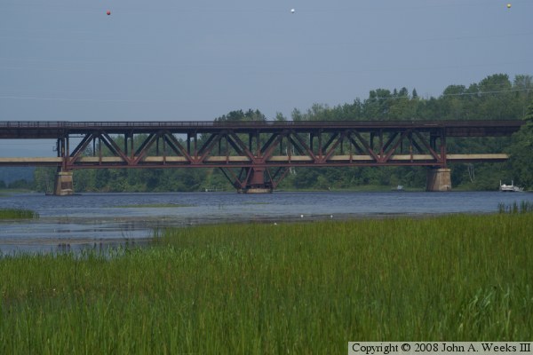
The photo above is a view of the swing span section at the east end of the
Oliver Bridge as seen from the Wisconsin DNR public water access boat landing
located just downstream on the east shore of the Saint Louis River.
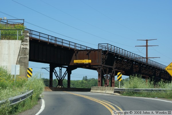
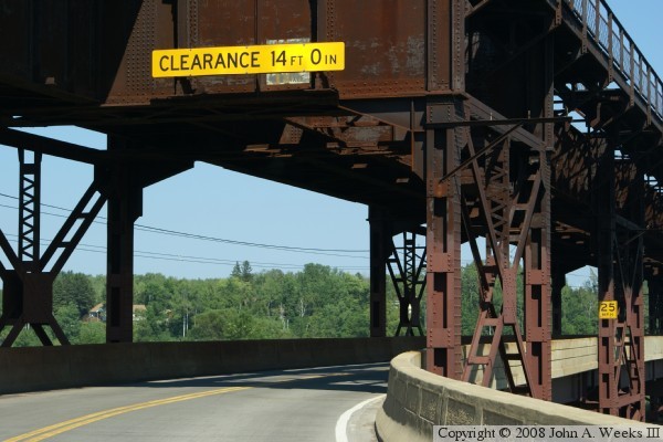
These two photos are the first of a six photo set showing a typical river
crossing heading eastbound on the highway deck. The photo above is
approaching the west end of the bridge. Due to the location of the bridge
abutment, there is a tight turn required to enter the bridge deck. The
photo below is a closer view of that turn. Note that the position of the
steel supports for the upper deck forces this turn to be very sharp.
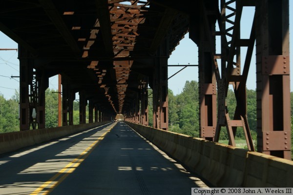
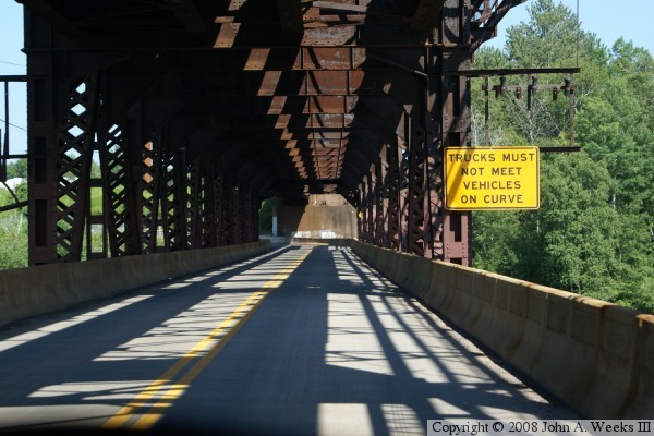
These two photos continue our eastbound bridge crossing. In these two photos,
we are traveling on the highway deck located under the railroad deck. The
photo above gives an impression of just how long this bridge is. The photo
below is the transition from the steel trestle section to the swing span,
which has its vertical truss members located much closer together than the
trestle section.
These two photos are the final photos in this six photo series showing a
typical eastbound bridge crossing. The photo above is the east bridge
abutment. Note that a section of bridge for the south rail line has been
removed at this end, too. The photo below is the curve exiting the east
end of the Oliver Bridge.
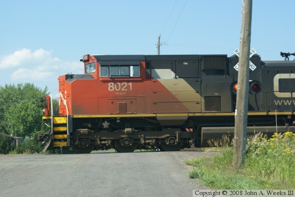
With dozens of trails per day using the Oliver Bridge, one does not have to
wait long to see a train crossing the bridge. Here, we see a Canadian
National train approaching from the east. Locomotive #8021 is a 4,300
horsepower EMD SD70M-2. The CN bought 140 of these locomotives, with this
unit being built in December, 2005.
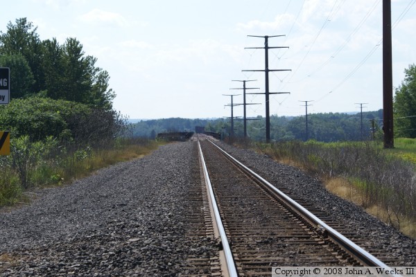
The photo above is looking west along the railroad tracks towards the rail
deck of the Oliver Bridge. The photo below is looking east from the access
road to the power lines located northwest of the bridge. This was the only
view of the side of the bridge that I was aware of until the found the
Wisconsin DNR public water access site on the east side of the river.
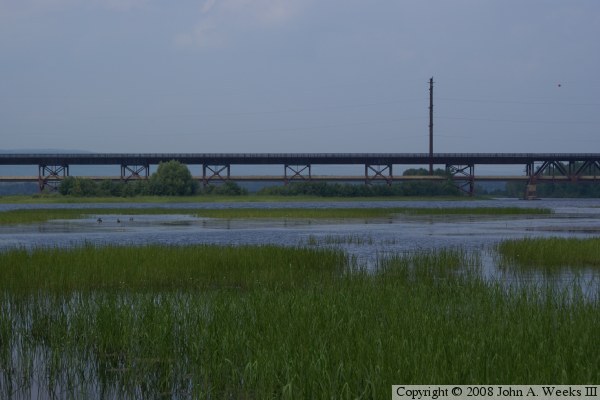
These two photos are views of the Oliver Bridge looking north from the public
water access site on the Wisconsin side of the river. The photo above is
the steel trestle spans on the west side of the main river channel. The photo
below is the east end of the bridge including the swing span.
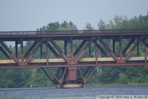
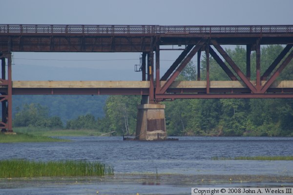
These two photos are details views of the bridge structure looking north from
the public water access site on the Wisconsin side of the river. The photo
above is the center pivot of the swing span. The photo below is the west
end of the swing span where it meets the trestle spans.