Current Weather Conditions
John A. Weeks III
Friday, July 26, 2024, 8:07:46 PM CDT
Home Photo Tours Rail Fan 12 Easy Steps
Aviation Spacecraft Highways & Bridges About The Author
 
Google Search
Maps   Groups   Images   Search
 
  Home
  • 12 Easy Steps
  • Aviation
  • Spacecraft
  • Highways & Bridges
    » Bridge Photography
      - MSP River Bridges
      - C & D Canal
      - Illinois River
      - Minnehaha Creek
      - Minnesota River
      - Mississippi River
      - Missouri River
      - St. Croix River
      - St. Louis River
        › St. Louis Headwaters
        › Upper St. Louis River
        › Forbes - US-53 Area
        › Up Mid St. Louis River
        › Lw Mid St. Louis River
        › Fond du Lac Reservatn
        › Cloquet - Scanlon
        › Jay Cooke State Park
        › Twin Ports Harbor
          · Oliver Bridge
          · Arrowhead Bridge
          · Grassy Point Trail
          · Grassy Point Bridge
          · Richard I. Bong Mem
          · Saint Louis Bay Br
          · John A. Blatnik Br
          · Interstate Bridge
          · Lamborn Ave Bridge
          · Minnesota Slip Draw
          · Aerial Lift Bridge
          · Barker's Is Trail Br
          · Barker's Is Causeway
          · Superior Entry
      - Wisconsin River
      - Best Miss River Photos
      - Cable Stayed Bridges
      - McGilvray Road Bridges
      - I-35W Bridge Disaster
      - Miscellaneous Bridges
      - Madison County Bridges
      - Hist Br Weekend 2013
    » Road Geek Topics
  • Photo Tours
  • Rail Fan
  • About The Author
 
Site Search By JRank
Highways, Byways, And Bridge Photography
Minnesota Slip Drawbridge
Saint Louis River Pedestrian Crossing
Duluth, MN

Minnesota Slip Drawbridge

• Structure ID: NBI: 69652
• Location: River Mile 5.0
• River Elevation: 602 Feet
• Bridge Type: Steel Bascule Drawbridge
• Bridge Length: 75 Feet, 75 Foot Longest Span
• Bridge Width: ??? Feet
• Navigation Channel Width: 75 Feet
• Height Above Water: ??? Feet
• Date Built: 1991
The Duluth waterfront rapidly evolved from a rundown industrial area to a tourist destination in the late 1980s and early 1990s. Three factors converged to make the Canal Park area the focus of this redevelopment. First, the historic buildings in the Canal Park area were available for redevelopment into shops, galleries, and restaurants. Second, the DECC convention center was greatly expanded. Third, a boardwalk was developed along Lake Superior.

As the development was in progress, the city ended up with a lot of pedestrian traffic in Canal Park, and a lot of pedestrian traffic by the DECC, but no way for people to easily move between the two locations. For example, if a show let out at the DECC, people would naturally want to head over to the Canal Park area for dinner and to stroll along the boardwalk. But this was all but impossible due to the Minnesota Slip boat channel blocking access between the two sites. While the slip is only 150 feet wide, its 1,000 foot length makes for nearly a half-mile walk.

Filling in the slip was not an option. The slip is home to two retired ships and a maritime museum, plus it is used by the harbor tour boats. A bridge seemed like the best option, however, being an active boat slip presented a key design problem. The bridge would either need to be high enough to allow for ocean-going ships to pass under the deck, or the bridge would need to move out of the way. A movable bridge seemed like the only option.

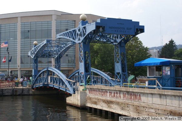
A second issue in the bridge design is the key location that it would fill in an area rich with history, plus it would be within view of the landmark Aerial Lift Bridge. Not just any bridge would do, and certainly not some precast concrete abomination. The design that emerged was for a counter-weight balanced double drawbridge modeled on a very common bridge style found in the Netherlands. The bridge deck was broken into two sections, each of which pivot at the two ends of the bridge. A set of towers would support a pair of pivoting arms. One end of the arms had counter-weights, and the other ends of the arms were attached to suspension rods that would lift the bridge spans. This style of lift bridge has a very simple design that is functional yet easy to maintain. In addition, all the works are fully external, making for a very interesting structure. The intricate metal work and artistic features make the bridge look like it is left over from a century ago, yet it is of 1991 vintage.

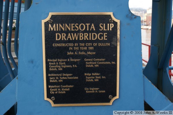
The Minnesota Slip Drawbridge has proven to be very successful. It has become a landmark in its own right. The bridge is heavily used by foot and bicycle traffic, and it has contributed to the economic success of both the DECC facility and the Canal Park development.

The photo above is looking northwest towards the Minnesota Slip Drawbridge from a parking lot on the east side of the slip. The photo below is looking east across the bridge deck towards Canal Park.


Minnesota Slip Drawbridge
The photo above is a view from the southeast corner of the Minnesota Slip Drawbridge. The building in the background is the DECC, the Duluth Entertainment Convention Center. The photo below is looking northeast from the southwest corner of the structure.

Minnesota Slip Drawbridge
The photo above is the bridge plate. The photo below is looking north from the deck of the drawbridge. The ship on the left is the S.S. William A. Irvin, which sailed the Great Lakes for 40 years and was once the flagship of the U.S. Steel Great Lakes Fleet. The ship on the right is the Coast Guard Cutter Sundew. The Sundew was launched in Duluth in 1944, and is now available for tour each summer between Memorial Day and Labor Day.

Minnesota Slip Drawbridge

Made With Macintosh
Authored by John A. Weeks III, Copyright © 1996—2016, all rights reserved.
For further information, contact: john@johnweeks.com