Current Weather Conditions
John A. Weeks III
Tuesday, February 9, 2010, 7:20:12 AM CST
Home 12 Easy Steps Random Topics About The Author Portal
Aviation Spacecraft Highways & Bridges Photo Tours Rail Fan

Google Search

 Maps  Groups
 Images  Search
  Home
  • 12 Easy Steps
  • Aviation
  • Spacecraft
  • Highways & Bridges
    » Bridge Photography
      - MSP River Bridges
      - Illinois River
      - Minnesota River
      - Mississippi River
        › Lake Itasca Area
        › Bemidji Area
        › Cass Lake - Ball Club
        › Grand Rapids Area
        › Blackberry - Crosby
        › Brainerd Lakes Area
        › Little Falls Area
        › St. Cloud Area
        › North Metro Area
        › Port Of Minneapolis
        › St. Anthony Falls Area
        › Mississippi Rvr Gorge
        › St. Paul Area
        › S St. Paul - Hastings
        › Red Wing - Winona
        › La Crosse Area
        › Lansing - Clinton
        › Quad Cities Area
        › Muscatine - Louisiana
          · Lock & Dam #16
          · Norbert F. Beckey Br
          · Lock & Dam #17
          · Keithsburg RR Br
          · Lock & Dam #18
          · Great River Bridge
          · Burlington RR Br
          · Ft Madison/Niota Br
          · Des Moines Rpds Can
          · Lock & Dam #19
          · Keokuk Municipal Br
          · Keokuk-Hamilton Br
          · Lock & Dam #20
          · Quincy Rail Br
          · Quincy Bay Rail Br
          · Quinsippi Island Br
          · The Pier Restaurant
          · Quincy Bayview Br
          · Quincy Soldier's Mem
          · Lock & Dam #21
          · Wabash Bridge
          · Mark Twain Mem Br
          · Lock & Dam #22
          · Champ Clark Bridge
          · Louisiana RR Br
          · Lock & Dam #24
          · Lock & Dam #25
          · Sandy Slough Bridge
        › St. Louis Area
        › Chester - Cairo
        › Miss - Tenn - Ark
        › Ark - Miss - Louisiana
        › Louisiana Structures
      - Missouri River
      - St. Croix River
      - St. Louis River
      - Wisconsin River
      - Cable Stayed Bridges
      - McGilvray Road
      - I-35W Bridge Disaster
      - Miscellaneous Bridges
    » Road Geek Topics
  • Random Topics
  • Photo Tours
  • Rail Fan
  • About The Author
  • John's Portal
 
Site Search By JRank
Highways, Byways, And Bridge Photography
Quincy Bayview Bridge
US-24 Mississippi River Crossing At Quincy
Quincy, Illinois

Quincy Bayview Bridge

• Structure ID: NBI 000001006819192.
• Location: River Mile 327.2.
• River Elevation: 470 Feet.
• Highway: US-24 (Westbound), Broadway Avenue.
• Daily Traffic Count: 17,900 (2003).
• Bridge Type: Cable Stayed.
• Length: 4,507 Feet Overall, 900 Feet Longest Span.
• Width: 32 Feet, 2 Lanes.
• Navigation Channel Width: 870 Feet.
• Height Above Water: 60 Feet.
• Date Built: Opened August 22, 1987.
In the 1980s, the City Of Quincy faced an interesting problem in that it's existing bridge was inadequate for the traffic, but the structure was still sound. The solution was to put up a second new twin bridge. The old bridge, which handles eastbound traffic, is called The Quincy Soldier's Memorial Bridge. The new bridge, which handles westbound traffic, is called the The Quincy Bayveiw Bridge. The new bridge was built about 900 feet north of the old bridge.

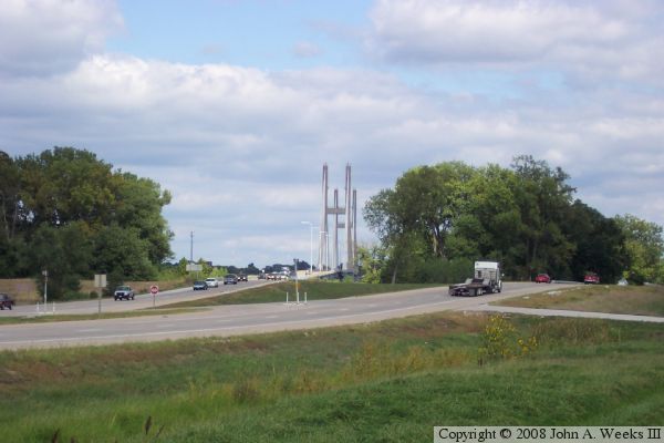
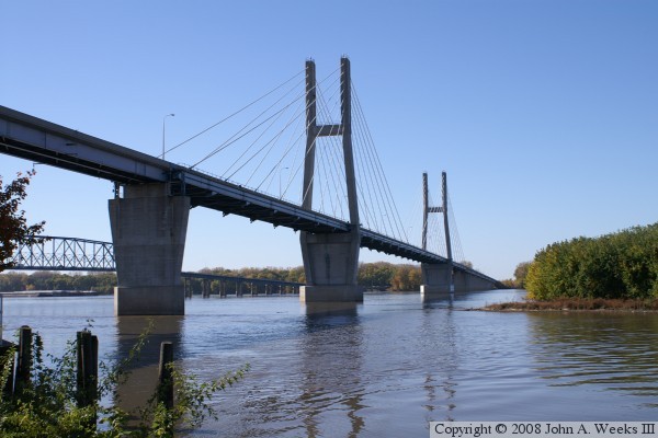
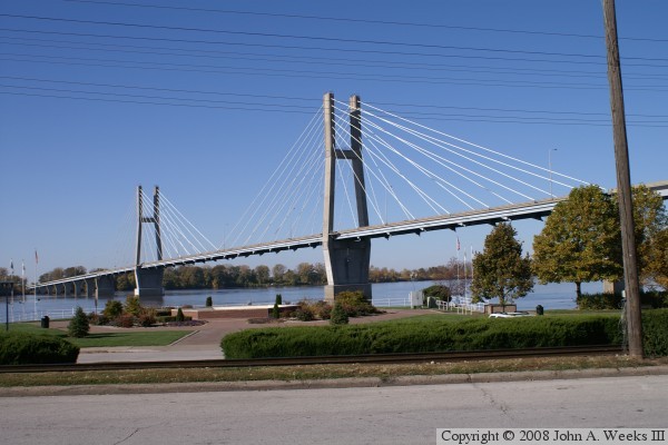
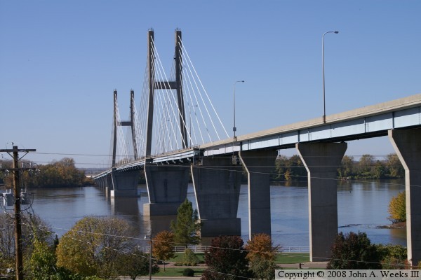
The Quincy Bayview Bridge is an early cable stay bridge, at least for the US. The bridge has 56 cables set up in 4 planes, with each plane having 7 cables on each side of the 182-foot main towers. Each pair of cables supports a 60 food long by 6 foot thick bridge deck section. The sections were unique at the time since they were a combination of prefabricated steel and precast concrete. Also unique was a new epoxy coating on the cables. Both the deck and cable features are now common features of cable stayed bridges.


Quincy Bayview Bridge

Made With Macintosh
Authored by John A. Weeks III, Copyright © 1996—2009, all rights reserved.
For further information, contact: john@johnweeks.com