Current Weather Conditions
John A. Weeks III
Friday, May 3, 2024, 12:40:41 AM CDT
Home Photo Tours Rail Fan 12 Easy Steps
Aviation Spacecraft Highways & Bridges About The Author
 
Google Search
Maps   Groups   Images   Search
 
  Home
  • 12 Easy Steps
  • Aviation
  • Spacecraft
  • Highways & Bridges
    » Bridge Photography
      - MSP River Bridges
      - C & D Canal
      - Illinois River
      - Minnehaha Creek
      - Minnesota River
      - Mississippi River
        › Lake Itasca Area
        › Bemidji Area
        › Cass Lake - Ball Club
        › Grand Rapids Area
        › Blackberry - Crosby
        › Brainerd Lakes Area
        › Little Falls Area
        › St. Cloud Area
        › North Metro Area
        › Port Of Minneapolis
        › St. Anthony Falls Area
        › Mississippi Rvr Gorge
        › St. Paul Area
        › S St. Paul - Hastings
        › Red Wing - Winona
        › La Crosse Area
        › Lansing - Clinton
        › Quad Cities Area
        › Muscatine - Louisiana
          · Lock & Dam #16
          · Norbert F. Beckey Br
          · Lock & Dam #17
          · Keithsburg RR Br
          · Lock & Dam #18
          · Great River Bridge
          · Burlington RR Br
          · Ft Madison/Niota Br
          · Des Moines Rpds Can
          · Lock & Dam #19
          · Keokuk Municipal Br
          · Keokuk-Hamilton Br
          · Lock & Dam #20
          · Quincy Rail Br
          · Quincy Bay Rail Br
          · Quinsippi Island Br
          · The Pier Restaurant
          · Quincy Bayview Br
          · Quincy Soldier's Mem
          · Lock & Dam #21
          · Wabash Bridge
          · Mark Twain Mem Br
          · Lock & Dam #22
          · Champ Clark Bridge
          · Louisiana RR Br
          · Lock & Dam #24
          · Lock & Dam #25
          · Sandy Slough Bridge
        › St. Louis Area
        › Chester - Cairo
        › Miss - Tenn - Ark
        › Ark - Miss - Louisiana
        › Louisiana Structures
      - Missouri River
      - St. Croix River
      - St. Louis River
      - Wisconsin River
      - Best Miss River Photos
      - Cable Stayed Bridges
      - McGilvray Road Bridges
      - I-35W Bridge Disaster
      - Miscellaneous Bridges
      - Madison County Bridges
      - Hist Br Weekend 2013
    » Road Geek Topics
  • Photo Tours
  • Rail Fan
  • About The Author
 
Site Search By JRank
Highways, Byways, And Bridge Photography
Lock & Dam #18
Mississippi River Lock & Dam
Gladstone, Illinois

Lock & Dam #18

• Structure: Lock & Dam #18.
• Location: River Mile 410.5.
• Dam Width: 8,900 Feet Overall, 1,350 Foot Main Structure.
• River Elevation (Pool): 528 Feet.
• River Elevation (Outflow): 518 Feet.
• Water Fall: 10 Feet.
• Annual Lock Traffic: 3,190 Vessels, 23,602,000 Tons (2005).
• Date Opened: September 8, 1937.
Gladstone is a very small town located on the Illinois side of the river just north of Burlington, Iowa. The Lock & Dam is located several miles from Gladstone. The route to the facility travels over farm roads, and then several thousand feet over the earthen embankment on the east side of the river. The Lock & Dam is more or less in the middle of the river, with long embankments on each side connecting the main structure to the river banks.

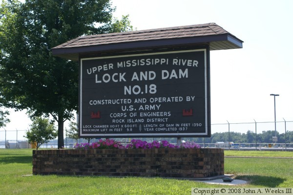
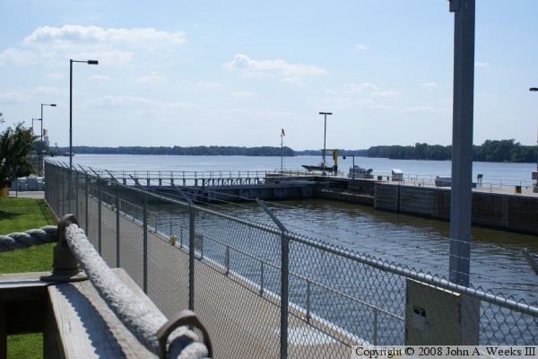
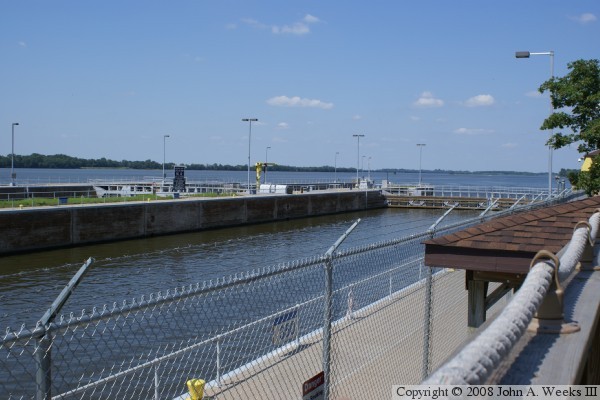
The main dam structure consists of 3 of the more modern roller gates and 14 of the older style Tainter gates. The lock is the standard size for the upper Mississippi River, 600 feet long by 110 feet wide. That means that they typical tow has to break into two parts to pass through the lock. There is also an uncompleted auxiliary lock.

This area is a popular place for bald eagles to spend the winter. As a result, bird watchers congregate at this location during the winter months to watch and photograph the majestic birds. One observer counted 400 eagles in view during one January afternoon.


Lock & Dam #18
Lock & Dam #18
Lock & Dam #18
Lock & Dam #18

Made With Macintosh
Authored by John A. Weeks III, Copyright © 1996—2016, all rights reserved.
For further information, contact: john@johnweeks.com