Current Weather Conditions
John A. Weeks III
Friday, May 3, 2024, 6:30:15 AM CDT
Home Photo Tours Rail Fan 12 Easy Steps
Aviation Spacecraft Highways & Bridges About The Author
 
Google Search
Maps   Groups   Images   Search
 
  Home
  • 12 Easy Steps
  • Aviation
  • Spacecraft
  • Highways & Bridges
    » Bridge Photography
      - MSP River Bridges
      - C & D Canal
      - Illinois River
      - Minnehaha Creek
      - Minnesota River
      - Mississippi River
        › Lake Itasca Area
        › Bemidji Area
        › Cass Lake - Ball Club
        › Grand Rapids Area
        › Blackberry - Crosby
        › Brainerd Lakes Area
        › Little Falls Area
        › St. Cloud Area
        › North Metro Area
        › Port Of Minneapolis
        › St. Anthony Falls Area
        › Mississippi Rvr Gorge
        › St. Paul Area
        › S St. Paul - Hastings
        › Red Wing - Winona
        › La Crosse Area
        › Lansing - Clinton
        › Quad Cities Area
        › Muscatine - Louisiana
          · Lock & Dam #16
          · Norbert F. Beckey Br
          · Lock & Dam #17
          · Keithsburg RR Br
          · Lock & Dam #18
          · Great River Bridge
          · Burlington RR Br
          · Ft Madison/Niota Br
          · Des Moines Rpds Can
          · Lock & Dam #19
          · Keokuk Municipal Br
          · Keokuk-Hamilton Br
          · Lock & Dam #20
          · Quincy Rail Br
          · Quincy Bay Rail Br
          · Quinsippi Island Br
          · The Pier Restaurant
          · Quincy Bayview Br
          · Quincy Soldier's Mem
          · Lock & Dam #21
          · Wabash Bridge
          · Mark Twain Mem Br
          · Lock & Dam #22
          · Champ Clark Bridge
          · Louisiana RR Br
          · Lock & Dam #24
          · Lock & Dam #25
          · Sandy Slough Bridge
        › St. Louis Area
        › Chester - Cairo
        › Miss - Tenn - Ark
        › Ark - Miss - Louisiana
        › Louisiana Structures
      - Missouri River
      - St. Croix River
      - St. Louis River
      - Wisconsin River
      - Best Miss River Photos
      - Cable Stayed Bridges
      - McGilvray Road Bridges
      - I-35W Bridge Disaster
      - Miscellaneous Bridges
      - Madison County Bridges
      - Hist Br Weekend 2013
    » Road Geek Topics
  • Photo Tours
  • Rail Fan
  • About The Author
 
Site Search By JRank
Highways, Byways, And Bridge Photography
Wabash Bridge
Norfolk Southern Mississippi River Crossing At Hannibal
Hannibal, Missouri

Wabash Bridge

• Structure ID:
• Location: River Mile 309.9.
• River Elevation: 460 Feet.
• Railroad: Norfolk Southern Railway.
• Daily Traffic Count: 12 Trains Per Day (Estimated).
• Bridge Type: Steel Truss Through Deck With Lift Section.
• Length: 1,584 Overall, 406 Foot Lift Span.
• Width: Single Track.
• Navigation Channel Width: 354 Feet.
• Height Above Water: 20 Feet.
• Date Built: 1871, 1888, and 1993.
The original 1871 bridge was only the second bridge between Illinois and Missouri when built by the Wabash Railroad. That bridge was used not only by trains, but also by horse and wagon traffic, later automobile traffic. The bridge became a rail-only structure when the highway bridge opened just downstream in 1936.

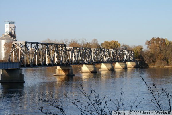
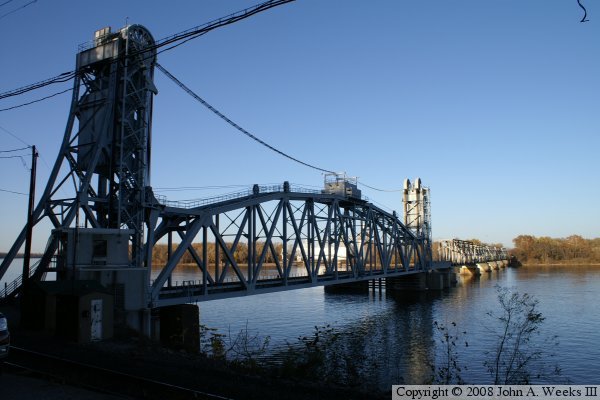
In 1883, the steam powered cast iron swing span was replaced by a steel swing span. That swing span was removed in 1993, and replaced with a lift section. The lift section doubled the width of the navigation channel, making river navigation easier for the larger tows commonly seen in the modern era. The lift section was not new, however. It was formerly in place across the Tennessee River near Florence, Alabama, and used by the Southern Railway. The swing span was removed and the lift span was installed with only a 3 day interruption in rail traffic.

The bridge was part of a Chicago to Kansas City route. Part of the track was built by the Wabash, and part built by the MKT. The Wabash later bought the MKT. The Wabash became part of the Norfolk and Western in 1964, which merged with the Southern Railway in the 1980's, becoming the Norfolk Southern.

The Wabash bridge is interesting in that the rail line enters a tunnel just after landing on the Missouri side of the river. There happens to be a high bluff on the west side of the river. The bluff has a rather sheer face. The solution was a 250 foot long tunnel through the bluff. Also note that the river crossing has a grade level railroad crossing right at the edge of the river. Those tracks carry the BNSF Railroad.

In the photos, you can see that one of the truss sections looks different from the others. That span was hit by a tow that had lost power in the heavy spring current on May 3, 1982, collapsing the truss section into the river. Three barges broke loose from the tow, drifted down river, and narrow missed taking down the Mart Twain Memorial Bridge.

Wabash Bridge
Wabash Bridge
Wabash Bridge

Made With Macintosh
Authored by John A. Weeks III, Copyright © 1996—2016, all rights reserved.
For further information, contact: john@johnweeks.com