The US Army started to clear the Mississippi River as early as 1829. Lieutenant Robert E. Lee ran a project from 1831 to 1833 to remove snags and blast the largest rocks in the rapids. While this made running the rapids a little less risky, it did not solve the problem. A canal would be the solution, but that would have to wait until after the Civil War was settled.
The Canal envisioned by Lee was approved and construction started in 1866. The canal was built along the west bank of the river. Starting at Keokuk, a wall was built 8 miles long to create a river channel that was independent of the main Mississippi River channel. This channel was deepened, and three locks were installed. This section of the canal opened to river traffic in 1877. A further 4 miles of canal was built south of Keokuk down to the Des Moines River. This was accomplished by blasting the bedrock to create a deeper channel along the west side of the river. This part of the canal was not separated from the main river as the upper portion was. The canal featured an overall depth of not less than 5 feet.
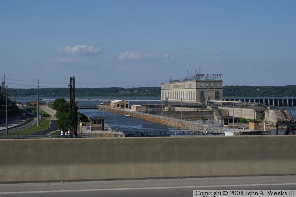
The Des Moines Rapids Canal was in operation for 36 years. Increasingly large river boats were too big to fit in the canal locks, and ever heavier barges required more than 5 feet of water depth. Congress responded by approving the 6 foot navigation channel plan. The result was the huge dam, the monumental power plant, and new Panama-sized lock that opened in 1913. Much of the old canal was destroyed and submerged when the new lock and dam opened. This structure is largely in place today. The major change is that the Panama-size lock was too small once Congress approved the 9-foot navigation channel plan. It was replaced with the current 1200-foot long lock.
Government records show that the canal operated for 239 days in 1890. Traffic included 924 steamboats, 477 barges, 14,529 passengers, 73,453 tons of merchandise, 397,788 bushels of grain, 26-million feet of lumber, 73-million shingles, and 44-million lath. The US Army Corps of Engineers budgeted $42,500 to operate the canal that year.
The photo above looks upstream from the new lock. The canal would have been located between the new lock and the powerhouse. The photo below shows the remains of the old locks that still exist. In the middle of those remains are a 10 foot section of a wall from the Des Moines Rapids Canal, the only piece of the canal that still exists. Note that people often referred to this canal by other names. It was called the Keokuk Boat Canal in many documents, and locals often called it the Government Canal given that it was paid for by the federal government.