Current Weather Conditions
John A. Weeks III
Friday, May 3, 2024, 3:16:08 AM CDT
Home Photo Tours Rail Fan 12 Easy Steps
Aviation Spacecraft Highways & Bridges About The Author
 
Google Search
Maps   Groups   Images   Search
 
  Home
  • 12 Easy Steps
  • Aviation
  • Spacecraft
  • Highways & Bridges
    » Bridge Photography
      - MSP River Bridges
      - C & D Canal
      - Illinois River
      - Minnehaha Creek
      - Minnesota River
      - Mississippi River
        › Lake Itasca Area
        › Bemidji Area
        › Cass Lake - Ball Club
        › Grand Rapids Area
        › Blackberry - Crosby
        › Brainerd Lakes Area
        › Little Falls Area
        › St. Cloud Area
        › North Metro Area
        › Port Of Minneapolis
        › St. Anthony Falls Area
        › Mississippi Rvr Gorge
        › St. Paul Area
        › S St. Paul - Hastings
        › Red Wing - Winona
        › La Crosse Area
        › Lansing - Clinton
        › Quad Cities Area
        › Muscatine - Louisiana
          · Lock & Dam #16
          · Norbert F. Beckey Br
          · Lock & Dam #17
          · Keithsburg RR Br
          · Lock & Dam #18
          · Great River Bridge
          · Burlington RR Br
          · Ft Madison/Niota Br
          · Des Moines Rpds Can
          · Lock & Dam #19
          · Keokuk Municipal Br
          · Keokuk-Hamilton Br
          · Lock & Dam #20
          · Quincy Rail Br
          · Quincy Bay Rail Br
          · Quinsippi Island Br
          · The Pier Restaurant
          · Quincy Bayview Br
          · Quincy Soldier's Mem
          · Lock & Dam #21
          · Wabash Bridge
          · Mark Twain Mem Br
          · Lock & Dam #22
          · Champ Clark Bridge
          · Louisiana RR Br
          · Lock & Dam #24
          · Lock & Dam #25
          · Sandy Slough Bridge
        › St. Louis Area
        › Chester - Cairo
        › Miss - Tenn - Ark
        › Ark - Miss - Louisiana
        › Louisiana Structures
      - Missouri River
      - St. Croix River
      - St. Louis River
      - Wisconsin River
      - Best Miss River Photos
      - Cable Stayed Bridges
      - McGilvray Road Bridges
      - I-35W Bridge Disaster
      - Miscellaneous Bridges
      - Madison County Bridges
      - Hist Br Weekend 2013
    » Road Geek Topics
  • Photo Tours
  • Rail Fan
  • About The Author
 
Site Search By JRank
Highways, Byways, And Bridge Photography
Lock & Dam #19
Mississippi River Lock & Dam
Keokuk, Iowa

Lock & Dam #19

• Structure: Lock & Dam #19.
• Location: River Mile 364.0.
• Dam Width: 6,665 Feet Overall, 4,250 Foot Main Structure.
• River Elevation (Pool): 518 Feet.
• River Elevation (Outflow): 480 Feet.
• Water Fall: 38.2 Feet.
• Annual Lock Traffic: 2,850 Vessels, 24,698,000 Tons (2005).
• Date Opened: August 26, 1914.
A large rapids once existed on the Mississippi River at Keokuk. The rapids had a total water fall of 28 feet. This meant that Keokuk was the head of navigation on the Mississippi River since boats could go no further north. Cargo that needed to travel up the upper river had to be off-loaded, carried by pack animal (later railroads) to a location north of Keokuk where boats could one again travel the great river.

The first attempt to conquer the rapids came just after the civil war. A 9 mile long canal was dug on the Iowa side of the river. This canal, which featured 3 locks, could accommodate small boats and rafts, but not the large riverboats. The canal was started in 1867, and was finished 10 years later.

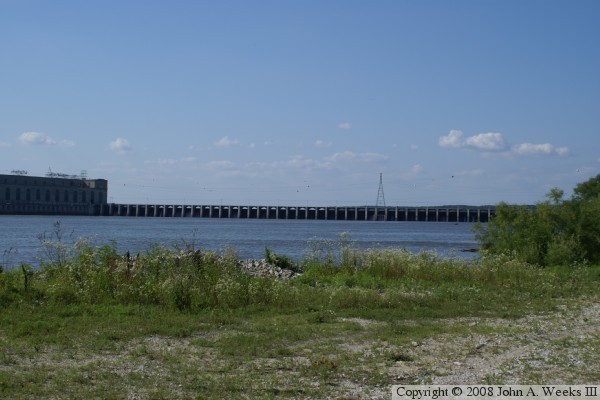
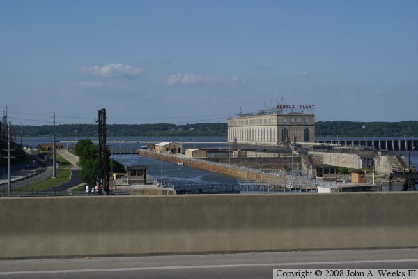
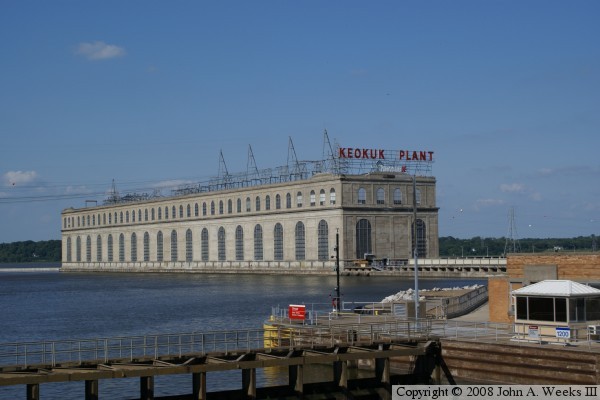
Around 1900, a lock and dam was funded for Keokuk as part of the 6 foot navigation project. The dam was built by a private company, but the US Army Corps of Engineers would build the lock. Building the dam was a monumental project, much like the modern day building of the Aswan High Dam or the Three Gorges project. People followed the project around the world, and folks traveled great distances to visit the site. When finished, the dam in 1913 and the lock in 1914, was the largest hydro power project in the world, producing 125-megawatts.

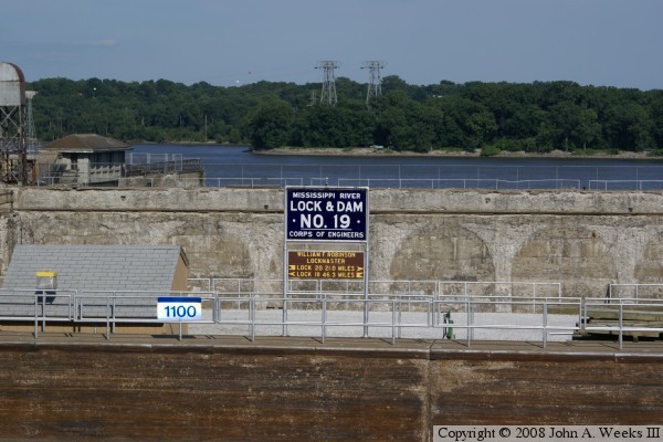
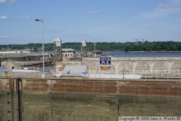
In the 1930's, Congress established the 9-foot navigation channel. This project standardized on 600 foot long locks. The Keokuk lock was not built that long. This eventually became a problem, but with the depression and the war, there was no money to address that problem. Finally in the 1950's, a new lock project was underway. It finished in 1957. The result was a 1200-foot long lock, one of only 3 on the Mississippi River that can lock the largest of the barge tows without having to break the tow into sections.

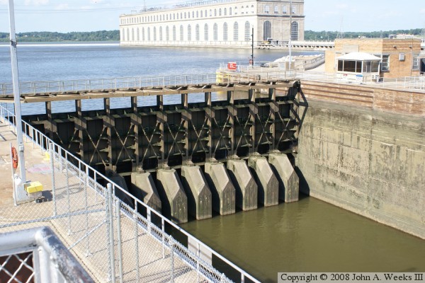
With the new lock now 50 years old, the structure is showing its age. The downriver lock doors began to fail in the late 1990's, and became dangerously close to breaking by 2002. A decision was made to replace the lock doors with a set of temporary doors that were on site, and have a new set of permanent doors fabricated. That took nearly 2 years to complete. The concrete work also needs major work, however, as of early 2007, that is not funded yet.

The Keokuk power station is somewhat unusual in that it is a 'run of the river' plant. That means that all water flowing down the river has to pass through the dam, power plant, or locks each day. There is no storage capacity in the upstream pond. This is different from many hydro power projects where the high water from spring runoff is captured and stored, then released later in the year as the river flow decreases. Over nearly 100 years of operation, the Keokuk Dam pond is filling with sediment due to the slowing of the river water in that area. The dam pond has been filled in by 50-percent so far. Prior to the dam, there was a thriving button pearl industry upstream. The clams would produce pearls that were the right size for making buttons. The additional sediment that accumulated after the dam opened made that part of the river unsuitable for the clams, which killed off the button industry in eastern Iowa. Today, buttons are nearly all made of synthetic materials.

In 2004, 15,271 loaded barges passed through Lock #19. Commodities accounted for 24.2-million tons, of which 8.8-million tons were headed up-river, while 15.4-million tons were headed down-river. In addition, 883 recreational vessels passed through the lock.


Lock & Dam #19
Lock & Dam #19
Lock & Dam #19
Lock & Dam #19
Lock & Dam #19
Lock & Dam #19
Lock & Dam #19
Lock & Dam #19
Lock & Dam #19
Lock & Dam #19
Lock & Dam #19
Lock & Dam #19
Lock & Dam #19

Made With Macintosh
Authored by John A. Weeks III, Copyright © 1996—2016, all rights reserved.
For further information, contact: john@johnweeks.com