Current Weather Conditions
John A. Weeks III
Saturday, July 27, 2024, 7:57:08 AM CDT
Home Photo Tours Rail Fan 12 Easy Steps
Aviation Spacecraft Highways & Bridges About The Author
 
Google Search
Maps   Groups   Images   Search
 
  Home
  • 12 Easy Steps
  • Aviation
  • Spacecraft
  • Highways & Bridges
    » Bridge Photography
      - MSP River Bridges
      - C & D Canal
      - Illinois River
      - Minnehaha Creek
      - Minnesota River
      - Mississippi River
        › Lake Itasca Area
        › Bemidji Area
        › Cass Lake - Ball Club
        › Grand Rapids Area
        › Blackberry - Crosby
        › Brainerd Lakes Area
        › Little Falls Area
        › St. Cloud Area
        › North Metro Area
        › Port Of Minneapolis
        › St. Anthony Falls Area
        › Mississippi Rvr Gorge
        › St. Paul Area
        › S St. Paul - Hastings
        › Red Wing - Winona
        › La Crosse Area
        › Lansing - Clinton
        › Quad Cities Area
        › Muscatine - Louisiana
        › St. Louis Area
          · Clark Superbridge
          · Melvin Price L&D
          · Chain Of Rocks Canal
          · New Chain Of Rocks
          · Double Chain Bridge
          · Chain Of Rocks Br
          · Single Chain Bridge
          · Water Intake Houses
          · Dam #27
          · Lock #27
          · Merchants Bridge
          · McKinley Bridge
          · McKinley Br (EB)
          · McKinley Br (WB)
          · Ronald W Reagan Br
          · Martin Luther King
          · Eads Bridge
          · Poplar Street Br
          · Gen D MacArthur Br
          · Jefferson Barracks Br
        › Chester - Cairo
        › Miss - Tenn - Ark
        › Ark - Miss - Louisiana
        › Louisiana Structures
      - Missouri River
      - St. Croix River
      - St. Louis River
      - Wisconsin River
      - Best Miss River Photos
      - Cable Stayed Bridges
      - McGilvray Road Bridges
      - I-35W Bridge Disaster
      - Miscellaneous Bridges
      - Madison County Bridges
      - Hist Br Weekend 2013
    » Road Geek Topics
  • Photo Tours
  • Rail Fan
  • About The Author
 
Site Search By JRank
Highways, Byways, And Bridge Photography
Dam #27
Mississippi River Dam
Granite City, Illinois

Dam #27

• Structure: Dam #27.
• Location: River Mile 190.2.
• Dam Width: 2,500 Feet.
• River Elevation (Pool): 399 Feet.
• River Elevation (Outflow): 396 Feet.
• Water Fall: 3 Feet.
• Date Opened: February 7, 1953.
By 1940, the locks and dams from Minneapolis down to Alton, Illinois, were in place and operational. The only challenge to navigation left on the upper Mississippi River was a series of rock ledges and shelves that extended for 17 miles on the north-east side of Saint Louis. Navigation through this area was impossible during lower water, and dangerous during high water.

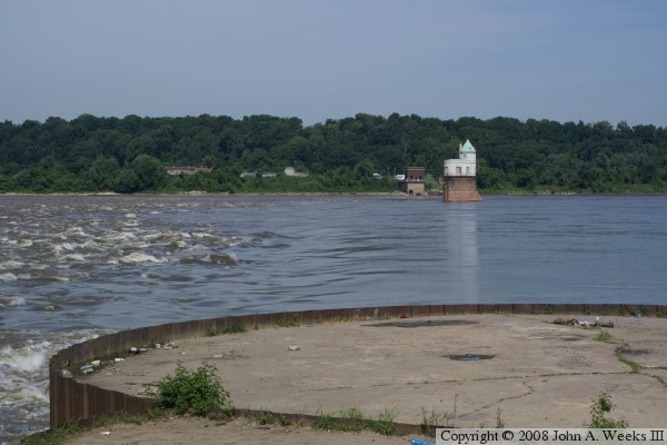
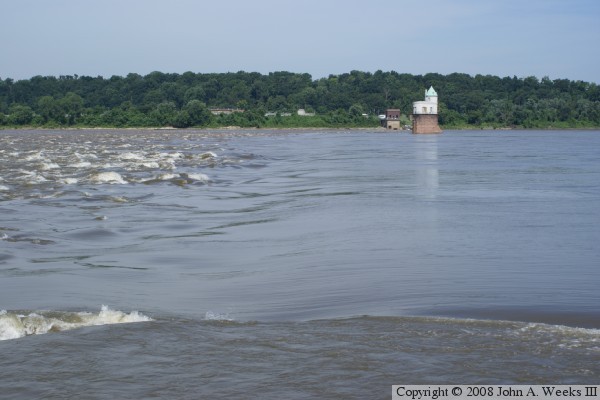
To solve this problem, the US Army Corps of Engineers designed and built the Chain Of Rocks Canal to bypass this area. A low water dam was built just below the north end of the canal. This ensured that the entrance to the canal had sufficient water depth for tow boats. A lock was installed at the south end of the canal.

The dam itself has no above water structure. Rather, it was built by dumping many barge loads of rock into the river. The dam is built just south of the old Chain Of Rocks Bridge, once part of historic route US-66. Pictures of the dam and bridge often show two small buildings in the middle of the river. These buildings look like miniature castles. They house the water intakes for the Saint Louis area water purification plant.


Dam #27

Made With Macintosh
Authored by John A. Weeks III, Copyright © 1996—2016, all rights reserved.
For further information, contact: john@johnweeks.com