Current Weather Conditions
John A. Weeks III
Thursday, September 2, 2010, 9:05:09 PM CDT
Home 12 Easy Steps Random Topics About The Author Portal
Aviation Spacecraft Highways & Bridges Photo Tours Rail Fan

Google Search

 Maps  Groups
 Images  Search
  Home
  • 12 Easy Steps
  • Aviation
  • Spacecraft
  • Highways & Bridges
    » Bridge Photography
      - MSP River Bridges
      - C & D Canal
      - Illinois River
      - Minnehaha Creek
      - Minnesota River
      - Mississippi River
        › Lake Itasca Area
        › Bemidji Area
        › Cass Lake - Ball Club
        › Grand Rapids Area
        › Blackberry - Crosby
        › Brainerd Lakes Area
        › Little Falls Area
          · Pink Bridge Ruins
          · MN-115 Bridge
          · US-10 Br (Main Ch)
          · US 10 Br (Back Ch)
          · BNSF Little Falls (N)
          · Broadway Bridge
          · Little Falls Ped Br
          · Little Falls Dam
          · Little Falls Ruins
          · BNSF Little Falls (S)
          · Blanchard Dam
          · Soo Line Bridge
          · Morrison Co Hwy 26
          · Btn & Strns Hwy 2
        › St. Cloud Area
        › North Metro Area
        › Port Of Minneapolis
        › St. Anthony Falls Area
        › Mississippi Rvr Gorge
        › St. Paul Area
        › S St. Paul - Hastings
        › Red Wing - Winona
        › La Crosse Area
        › Lansing - Clinton
        › Quad Cities Area
        › Muscatine - Louisiana
        › St. Louis Area
        › Chester - Cairo
        › Miss - Tenn - Ark
        › Ark - Miss - Louisiana
        › Louisiana Structures
      - Missouri River
      - St. Croix River
      - St. Louis River
      - Wisconsin River
      - Cable Stayed Bridges
      - McGilvray Road
      - I-35W Bridge Disaster
      - Miscellaneous Bridges
    » Road Geek Topics
  • Random Topics
  • Photo Tours
  • Rail Fan
  • About The Author
  • John's Portal
 
Site Search By JRank
Highways, Byways, And Bridge Photography
BNSF Bridge — Little Falls (South)
Mississippi River Railroad Crossing
Little Falls, MN

BNSF Bridge Little Falls

• Location: River Mile 965
• River Elevation: 1,083 Feet
• County: Morrison
• Railroad: BNSF Railroad
• Daily Traffic Count: 50 Trains Per Day (Estimated)
• Bridge Type: Concrete Girder
• Bridge Length: 566 Feet, 62 Foot Longest Span
• Bridge Width: 14 Feet, 1 Track
• Height Above Water: 17 Feet
• Date Built: 1990
The main BNSF Railroad river crossing at Little Falls is located just south of the city, where it crosses the river on a diagonal from southeast to northwest. It is part of the very heavily used BNSF mainline from Minneapolis to points west. The route follows US-10 west of the Twin Cities, crosses the river at Little Falls, then heads towards Staples, where it joins the Duluth to Fargo mainline.

Little Falls exists because of the railroad. It was founded in 1871 by the Northern Pacific Railroad. The first river crossing at this location was a ferry started in 1868. A wood trestle was built in 1877 by the NP. It was replaced in with a wooden through truss bridge, which was later replaced by a plate deck girder bridge. That bridge was replaced by the current pre-stressed concrete girder bridge.


BNSF Bridge Little Falls
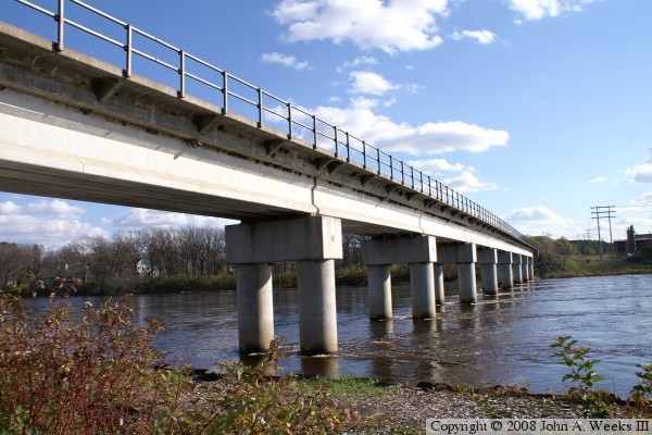
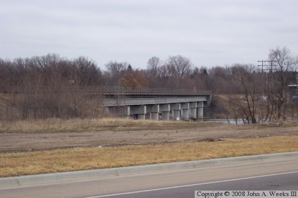
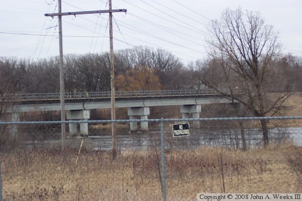
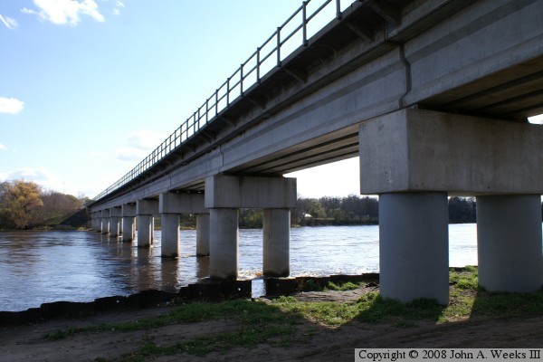
The photo above is the south face of the rail bridge as seen from the highway that runs along the west side of the river. The photo below is a similar view from two blocks further downriver. The photo at the top of the page is the south face of the rail bridge as seen from the 
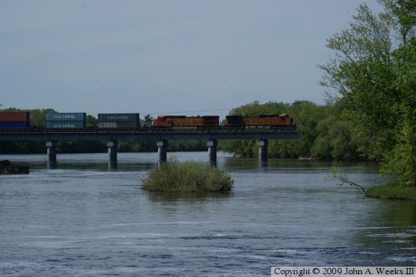
water level just south of the structure.

BNSF Bridge Little Falls
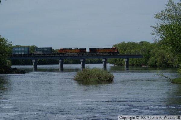
These two views are looking west across the Mississippi River from Maple Island Park just south of the downtown business area. This seen shows a pair of BNSF locomotives crossing the bridge northbound pulling a mile long train loaded with double-stack containers. These locomotives are General Electric C44-9W units that develop 4,400 horse power each. The lead unit is #5346, which went into service in May, 2001, while the second unit is #4960, which went into service in November, 1998.

BNSF Bridge Little Falls
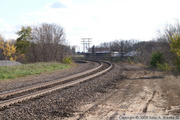
The photo above is the north face of the BNSF railroad bridge looking east across the Mississippi River. The photo below is looking southeast down the railline towards the river bridge. The river is just beyond the trees on either side of the track. The tanks in the background is part of the Little Falls city wastewater treatment plant, and are located on the far side of the river.

BNSF Bridge Little Falls

Made With Macintosh
Authored by John A. Weeks III, Copyright © 1996—2010, all rights reserved.
For further information, contact: john@johnweeks.com