Current Weather Conditions
John A. Weeks III
Thursday, September 2, 2010, 8:23:57 PM CDT
Home 12 Easy Steps Random Topics About The Author Portal
Aviation Spacecraft Highways & Bridges Photo Tours Rail Fan

Google Search

 Maps  Groups
 Images  Search
  Home
  • 12 Easy Steps
  • Aviation
  • Spacecraft
  • Highways & Bridges
    » Bridge Photography
      - MSP River Bridges
      - C & D Canal
      - Illinois River
      - Minnehaha Creek
      - Minnesota River
      - Mississippi River
        › Lake Itasca Area
        › Bemidji Area
        › Cass Lake - Ball Club
        › Grand Rapids Area
        › Blackberry - Crosby
        › Brainerd Lakes Area
        › Little Falls Area
          · Pink Bridge Ruins
          · MN-115 Bridge
          · US-10 Br (Main Ch)
          · US 10 Br (Back Ch)
          · BNSF Little Falls (N)
          · Broadway Bridge
          · Little Falls Ped Br
          · Little Falls Dam
          · Little Falls Ruins
          · BNSF Little Falls (S)
          · Blanchard Dam
          · Soo Line Bridge
          · Morrison Co Hwy 26
          · Btn & Strns Hwy 2
        › St. Cloud Area
        › North Metro Area
        › Port Of Minneapolis
        › St. Anthony Falls Area
        › Mississippi Rvr Gorge
        › St. Paul Area
        › S St. Paul - Hastings
        › Red Wing - Winona
        › La Crosse Area
        › Lansing - Clinton
        › Quad Cities Area
        › Muscatine - Louisiana
        › St. Louis Area
        › Chester - Cairo
        › Miss - Tenn - Ark
        › Ark - Miss - Louisiana
        › Louisiana Structures
      - Missouri River
      - St. Croix River
      - St. Louis River
      - Wisconsin River
      - Cable Stayed Bridges
      - McGilvray Road
      - I-35W Bridge Disaster
      - Miscellaneous Bridges
    » Road Geek Topics
  • Random Topics
  • Photo Tours
  • Rail Fan
  • About The Author
  • John's Portal
 
Site Search By JRank
Highways, Byways, And Bridge Photography
Little Falls Dam Suspension Bridge
Mississippi River Pedestrian Crossing
Little Falls, MN

Little Falls Dam Suspension Bridge

• Structure ID: N/A
• Location: River Mile 965.2
• River Elevation: 1,107 Feet
• County: Morrison
• Bridge Type: Suspension Bridge
• Bridge Length: 150 Feet (Estimated)
• Bridge Width: 15 Feet (Estimated)
• Height Above Water: 10 Feet (Estimated)
• Date Built: ???
There have been dams at the Little Falls of the Mississippi River since 1858. These dams have included pedestrian bridges to provide access for workers to commute by foot to the mills and factories located along the west side of the river, and for travelers to cross the great river.

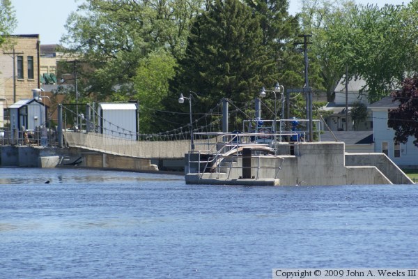
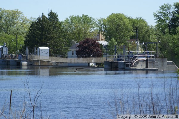
The current pedestrian bridge is a pure suspension bridge. It is suspended on cables strung between two sets of poles that rise about 22 feet above the water level. The poles are set about 14 feet apart, while the bridge span is about 150 feet. This bridge is not open to the public. It may have been open to the public at one time, but today, it is used to support the operation of the dam.

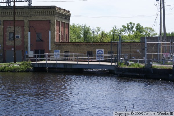
The photo above is the suspension bridge as seen from the east side of the Mississippi River from a vantage point located upriver from the dam. The photo below is a bridge over the old powerplant intake that leads to the suspension bridge.


Little Falls Dam Suspension Bridge
These two photos are views of the suspension bridge from the west side of the river. The photo above is looking mostly east, while the photo below is looking southeast.

Little Falls Dam Suspension Bridge

Made With Macintosh
Authored by John A. Weeks III, Copyright © 1996—2010, all rights reserved.
For further information, contact: john@johnweeks.com