Current Weather Conditions
John A. Weeks III
Saturday, July 27, 2024, 4:11:56 AM CDT
Home Photo Tours Rail Fan 12 Easy Steps
Aviation Spacecraft Highways & Bridges About The Author
 
Google Search
Maps   Groups   Images   Search
 
  Home
  • 12 Easy Steps
  • Aviation
  • Spacecraft
  • Highways & Bridges
    » Bridge Photography
      - MSP River Bridges
      - C & D Canal
      - Illinois River
      - Minnehaha Creek
      - Minnesota River
      - Mississippi River
        › Lake Itasca Area
        › Bemidji Area
        › Cass Lake - Ball Club
        › Grand Rapids Area
        › Blackberry - Crosby
        › Brainerd Lakes Area
        › Little Falls Area
          · Pink Bridge Ruins
          · MN-115 Bridge
          · US-10 Br (Main Ch)
          · US 10 Br (Back Ch)
          · BNSF Little Falls (N)
          · Broadway Bridge
          · Little Falls Ped Br
          · Little Falls Dam
          · Little Falls Mill Ruins
          · BNSF Little Falls (S)
          · Blanchard Hydro Stn
          · Soo Line Trail Bridge
          · Morrison Co Hwy 26
          · Btn & Strns Hwy 2
        › St. Cloud Area
        › North Metro Area
        › Port Of Minneapolis
        › St. Anthony Falls Area
        › Mississippi Rvr Gorge
        › St. Paul Area
        › S St. Paul - Hastings
        › Red Wing - Winona
        › La Crosse Area
        › Lansing - Clinton
        › Quad Cities Area
        › Muscatine - Louisiana
        › St. Louis Area
        › Chester - Cairo
        › Miss - Tenn - Ark
        › Ark - Miss - Louisiana
        › Louisiana Structures
      - Missouri River
      - St. Croix River
      - St. Louis River
      - Wisconsin River
      - Best Miss River Photos
      - Cable Stayed Bridges
      - McGilvray Road Bridges
      - I-35W Bridge Disaster
      - Miscellaneous Bridges
      - Madison County Bridges
      - Hist Br Weekend 2013
    » Road Geek Topics
  • Photo Tours
  • Rail Fan
  • About The Author
 
Site Search By JRank
Highways, Byways, And Bridge Photography
Little Falls Dam
Mississippi River Dam
Little Falls, MN

Little Falls Dam

• Location: River Mile 965.2
• County: Morrison
• Structure Type: Concrete Structure
• Structure Width: 1,035 Feet (Estimated)
• River Elevation (Pool): 1,107 Feet
• River Elevation (Outflow): 1,083 Feet
• Water Fall: 24 Feet
• Date Built: 1887
There were a number of privately owned dams built in the Little Falls area to serve the timber industry. The current dam was built in 1887 and went into operation in 1888. It supplied mechanical power to a flour mill via a series of belts and pulleys. Interestingly, a previous dam at this location also served as a bridge over the Mississippi River for 18 months prior to that dam being destroyed by a flood in 1859.

The Little Falls dam was converted to hydropower in the 1890s. The Little Falls power company ran a promotion where they would wire a house for free if the customer signed up for at least 6 electric lights. The dam currently produces 4.5-megawatts of power. Generators 1, 2, and 3 are in the newer powerhouse and were installed in 1924. Generators 5 and 6 are in the older powerhouse, and date back to 1906. Unit 4 was put into operation in 1979. Electric power generated from this dam cost about 7 cents per kilowatt/hour back in the early 1900s. The price is exactly the same over 100 years later.

The Little Falls dam operates as a run-of-the-river dam. That is, each drop of water that flows into the dam area has to pass through the power house or go over the dam each day. There is no storage reservoir behind the dam.

The photo above is a view of the face of the newer eastern section of the dam structure. Notice that a suspension pedestrian bridge spans across the main spillway. This is one of the few suspension bridges that exist in Minnesota.


Little Falls Dam
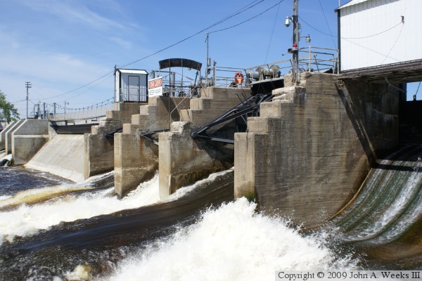
The photo above is a view of the control gates on the east side of the dam. The photo below is the newer spillway structure.

Little Falls Dam
Little Falls Dam
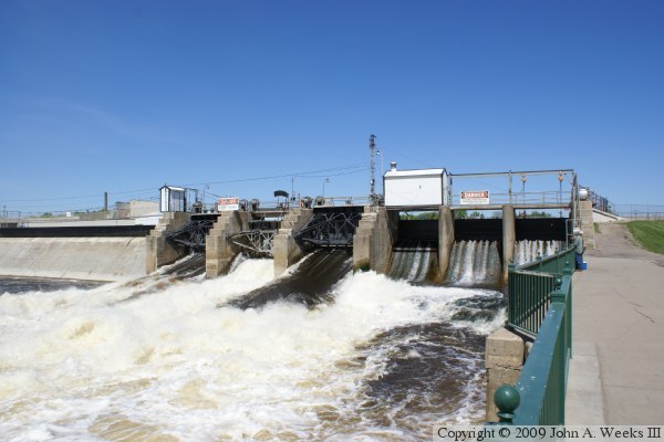
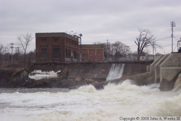
The photo above is the mid-river gates. An older section of the dam is 
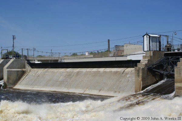
visible in the background. The photo below is the dam as seen from the west side of the river.

Little Falls Dam
Little Falls Dam
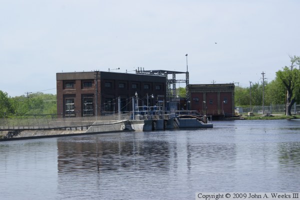
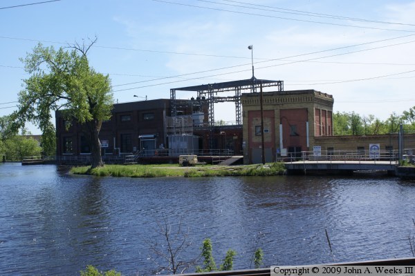
The photo above is the powerplant complex as seen from the east side of the river. The new powerplant is the closer structure. The photo below is a view of the powerplant from the west side of the river. The historic older powerplant is on the right side of the photo. The suspension pedestrian bridge is visible in the upper photo, while a pedestrian bridge over the old powerplant intake is shown in the photo below.

Little Falls Dam
Little Falls Dam
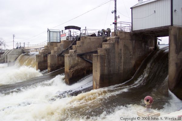
The photo above is the control structure at the east end of the dam during a period of very high water following a sudden spring thaw. The photo below is the west end of the dam structure and the powerplant.

Little Falls Dam

Made With Macintosh
Authored by John A. Weeks III, Copyright © 1996—2016, all rights reserved.
For further information, contact: john@johnweeks.com