Current Weather Conditions
John A. Weeks III
Friday, July 26, 2024, 11:26:08 PM CDT
Home Photo Tours Rail Fan 12 Easy Steps
Aviation Spacecraft Highways & Bridges About The Author
 
Google Search
Maps   Groups   Images   Search
 
  Home
  • 12 Easy Steps
  • Aviation
  • Spacecraft
  • Highways & Bridges
    » Bridge Photography
      - MSP River Bridges
      - C & D Canal
      - Illinois River
      - Minnehaha Creek
      - Minnesota River
      - Mississippi River
        › Lake Itasca Area
        › Bemidji Area
        › Cass Lake - Ball Club
        › Grand Rapids Area
        › Blackberry - Crosby
        › Brainerd Lakes Area
        › Little Falls Area
        › St. Cloud Area
        › North Metro Area
        › Port Of Minneapolis
        › St. Anthony Falls Area
        › Mississippi Rvr Gorge
        › St. Paul Area
        › S St. Paul - Hastings
        › Red Wing - Winona
        › La Crosse Area
          · Lock & Dam #7
          · Dresbach Bridge
          · Round Lake Bridge
          · French Slough Bridge
          · Rest Area Bridge
          · Black River Channel
          · Hiawatha Islands Br
          · Clinton Street Bridge
          · Fisherman's Bridge
          · CP RR La Crosse
          · CP RR East Channel
          · CP RR French Slough
          · CP RR Black Rr Br
          · Pettibone Park Br
          · The Miss River Br
          · West Channel Bridge
          · Isle La Plume Foot Br
          · Niedbalski Bridge
          · Green Island Bridge
          · Goose Island Bridge
        › Lansing - Clinton
        › Quad Cities Area
        › Muscatine - Louisiana
        › St. Louis Area
        › Chester - Cairo
        › Miss - Tenn - Ark
        › Ark - Miss - Louisiana
        › Louisiana Structures
      - Missouri River
      - St. Croix River
      - St. Louis River
      - Wisconsin River
      - Best Miss River Photos
      - Cable Stayed Bridges
      - McGilvray Road Bridges
      - I-35W Bridge Disaster
      - Miscellaneous Bridges
      - Madison County Bridges
      - Hist Br Weekend 2013
    » Road Geek Topics
  • Photo Tours
  • Rail Fan
  • About The Author
 
Site Search By JRank
Highways, Byways, And Bridge Photography
Rest Area Bridge
I-90 Mississippi River Crossing At La Crosse
La Crosse, Wisconsin

Rest Area Bridge

• Structure ID: NBI 32007500000000.
• Location: River Mile 701.8.
• River Elevation: 631 Feet.
• Highway: I-90 Eastbound Rest Area Entrance.
• Daily Traffic Count: 900 (2003).
• Bridge Type: Continuous Concrete Slab.
• Length: 133 Feet.
• Width: 31 Feet.
• Navigation Channel Width: Non-Navigable.
• Height Above Water:  
• Date Built: Built 1976.
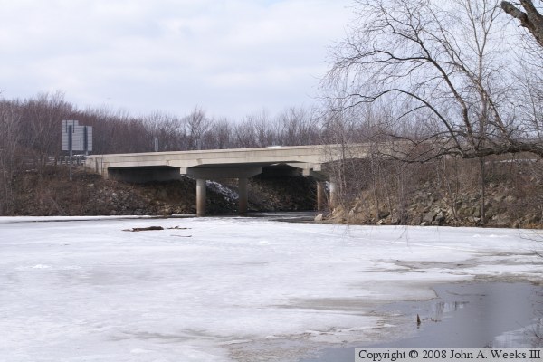
After I-90 had been open for a few years, Wisconsin DOT wanted to put in a state entry rest area and tourist information center. The first dry land after entering the state from Minnesota was on the western edge of French Island. While there was enough land for the rest area and the exit road, there was no place to put the entrance road. As a result, the I-90 causeway near French Slough was made wider, and a small bridge was put in place parallel to the existing two I-90 bridges over French Slough. That solved the entrance road issue in a very clean and safe manner.

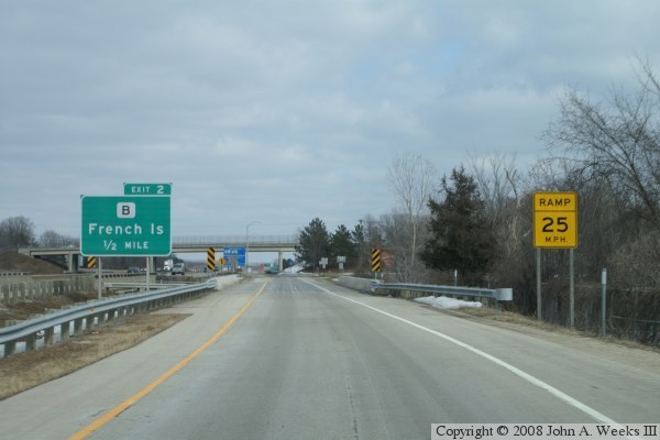
The photo above is looking north from the rest area nature trail towards the rest area bridge. The photo below is taken just after exiting I-90 Eastbound and prior to crossing the bridge or entering the rest area.


Rest Area Bridge

Made With Macintosh
Authored by John A. Weeks III, Copyright © 1996—2016, all rights reserved.
For further information, contact: john@johnweeks.com