Current Weather Conditions
John A. Weeks III
Saturday, July 27, 2024, 4:06:42 AM CDT
Home Photo Tours Rail Fan 12 Easy Steps
Aviation Spacecraft Highways & Bridges About The Author
 
Google Search
Maps   Groups   Images   Search
 
  Home
  • 12 Easy Steps
  • Aviation
  • Spacecraft
  • Highways & Bridges
    » Bridge Photography
      - MSP River Bridges
      - C & D Canal
      - Illinois River
      - Minnehaha Creek
      - Minnesota River
      - Mississippi River
        › Lake Itasca Area
        › Bemidji Area
        › Cass Lake - Ball Club
        › Grand Rapids Area
        › Blackberry - Crosby
        › Brainerd Lakes Area
        › Little Falls Area
        › St. Cloud Area
        › North Metro Area
        › Port Of Minneapolis
        › St. Anthony Falls Area
        › Mississippi Rvr Gorge
        › St. Paul Area
        › S St. Paul - Hastings
        › Red Wing - Winona
        › La Crosse Area
          · Lock & Dam #7
          · Dresbach Bridge
          · Round Lake Bridge
          · French Slough Bridge
          · Rest Area Bridge
          · Black River Channel
          · Hiawatha Islands Br
          · Clinton Street Bridge
          · Fisherman's Bridge
          · CP RR La Crosse
          · CP RR East Channel
          · CP RR French Slough
          · CP RR Black Rr Br
          · Pettibone Park Br
          · The Miss River Br
          · West Channel Bridge
          · Isle La Plume Foot Br
          · Niedbalski Bridge
          · Green Island Bridge
          · Goose Island Bridge
        › Lansing - Clinton
        › Quad Cities Area
        › Muscatine - Louisiana
        › St. Louis Area
        › Chester - Cairo
        › Miss - Tenn - Ark
        › Ark - Miss - Louisiana
        › Louisiana Structures
      - Missouri River
      - St. Croix River
      - St. Louis River
      - Wisconsin River
      - Best Miss River Photos
      - Cable Stayed Bridges
      - McGilvray Road Bridges
      - I-35W Bridge Disaster
      - Miscellaneous Bridges
      - Madison County Bridges
      - Hist Br Weekend 2013
    » Road Geek Topics
  • Photo Tours
  • Rail Fan
  • About The Author
 
Site Search By JRank
Highways, Byways, And Bridge Photography
CP Rail French Slough Bridge
CP Rail Mississippi River Crossing At La Crosse
La Crosse, Wisconsin

CP Rail French Slough Bridge

• Structure ID:  
• Location: River Mile 699.3.
• River Elevation: 631 Feet.
• Railroad: Canadian Pacific Railroad.
• Daily Traffic Count: 28 Trains Per Day.
• Bridge Type: Steel Plate Girder.
• Length: 812 Feet, 82 Foot Longest Span.
• Width: 18 Feet, 1 Track.
• Navigation Channel Width: Non-Navigable.
• Height Above Water: 22 Feet.
• Date Built: 1998, Crossing Dates To November 1876.
This bridge is one of the first 15 bridges to cross the Mississippi River. The bridge dates back to 1876. The first bridge was a trestle with stone piers. In 1905, a steel through truss was installed. In 1998, the main spans were replaced with pony plate girder spans. At the same time, the stone piers were encased in concrete, giving this very old bridge a very modern look.

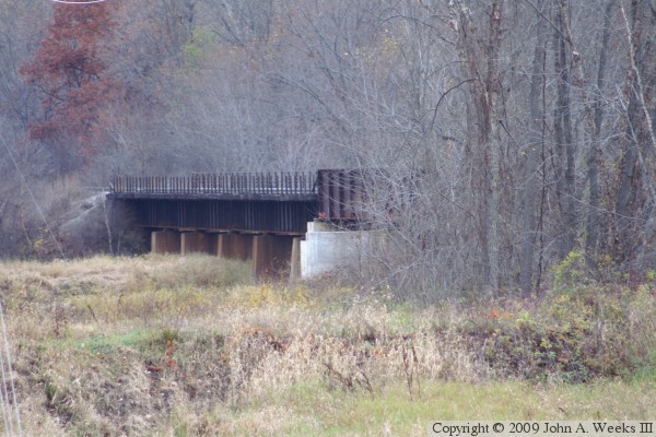
This bridge is part of a total of 4 bridges that make up the La Crosse railroad crossing. These bridges are, moving east, the Main Channel Rail Bridge, East Channel Rail Bridge, this bridge (French Slough Rail Bridge), and the Black River Channel Rail Bridge. These bridges were built by the Milwaukee Road, which merged with the Soo Line, which has since been bought out by the Canadian Pacific Railway. The La Crosse rail bridge is one of three places that the Amtrack Empire Builder passenger train crosses the Mississippi River (the other two are Hastings, MN, and Little Falls, MN).

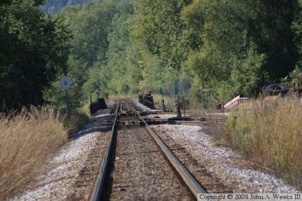
In the photo above, the bridge is just beyond the second railroad switch. This view is looking about a quarter mile down the track with a telephoto lens. It has the effect of compressing the background, making the bridge appear to look relatively short. The two switch closest to the bridge leads to a very busy Canadian Pacific repair yard located just to the north of the mainline. The second switch leads to an industrial spur on French Island. The photo below is a view of the south face of the bridge while looking to the northwest from a location near the Excel Energy plant at the southern tip of French Island.


CP Rail French Slough Bridge

Made With Macintosh
Authored by John A. Weeks III, Copyright © 1996—2016, all rights reserved.
For further information, contact: john@johnweeks.com