Current Weather Conditions
John A. Weeks III
Saturday, July 27, 2024, 1:36:26 AM CDT
Home Photo Tours Rail Fan 12 Easy Steps
Aviation Spacecraft Highways & Bridges About The Author
 
Google Search
Maps   Groups   Images   Search
 
  Home
  • 12 Easy Steps
  • Aviation
  • Spacecraft
  • Highways & Bridges
    » Bridge Photography
      - MSP River Bridges
      - C & D Canal
      - Illinois River
      - Minnehaha Creek
      - Minnesota River
      - Mississippi River
        › Lake Itasca Area
        › Bemidji Area
        › Cass Lake - Ball Club
        › Grand Rapids Area
        › Blackberry - Crosby
        › Brainerd Lakes Area
        › Little Falls Area
        › St. Cloud Area
        › North Metro Area
        › Port Of Minneapolis
        › St. Anthony Falls Area
        › Mississippi Rvr Gorge
        › St. Paul Area
        › S St. Paul - Hastings
        › Red Wing - Winona
        › La Crosse Area
          · Lock & Dam #7
          · Dresbach Bridge
          · Round Lake Bridge
          · French Slough Bridge
          · Rest Area Bridge
          · Black River Channel
          · Hiawatha Islands Br
          · Clinton Street Bridge
          · Fisherman's Bridge
          · CP RR La Crosse
          · CP RR East Channel
          · CP RR French Slough
          · CP RR Black Rr Br
          · Pettibone Park Br
          · The Miss River Br
          · West Channel Bridge
          · Isle La Plume Foot Br
          · Niedbalski Bridge
          · Green Island Bridge
          · Goose Island Bridge
        › Lansing - Clinton
        › Quad Cities Area
        › Muscatine - Louisiana
        › St. Louis Area
        › Chester - Cairo
        › Miss - Tenn - Ark
        › Ark - Miss - Louisiana
        › Louisiana Structures
      - Missouri River
      - St. Croix River
      - St. Louis River
      - Wisconsin River
      - Best Miss River Photos
      - Cable Stayed Bridges
      - McGilvray Road Bridges
      - I-35W Bridge Disaster
      - Miscellaneous Bridges
      - Madison County Bridges
      - Hist Br Weekend 2013
    » Road Geek Topics
  • Photo Tours
  • Rail Fan
  • About The Author
 
Site Search By JRank
Highways, Byways, And Bridge Photography
Isle La Plume Foot Bridge
Regional Trail Mississippi River Crossing At La Crosse
La Crosse, Wisconsin

Isle La Plume Foot Bridge

• Structure ID:
• Location: River Mile 697.2.
• River Elevation: 631 Feet.
• Highway: Isle La Plume Regional Trail.
• Daily Traffic Count: 0, Closed To Vehicles.
• Bridge Type: Wooden Trestle.
• Length: 110 Feet (Estimated).
• Width: 14 Feet (Estimated).
• Navigation Channel Width: Non-Navigable.
• Height Above Water: Unknown.
• Date Built:
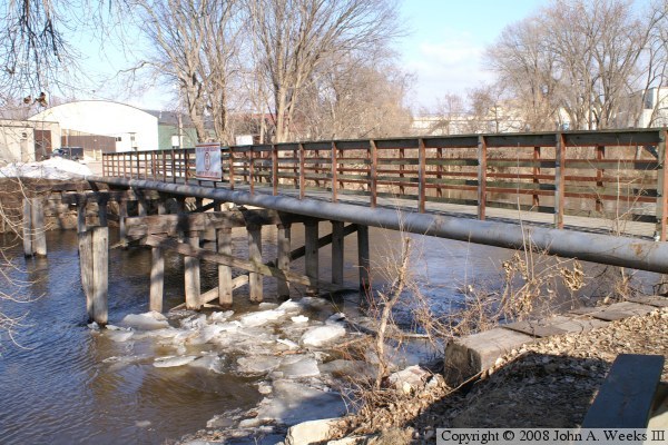
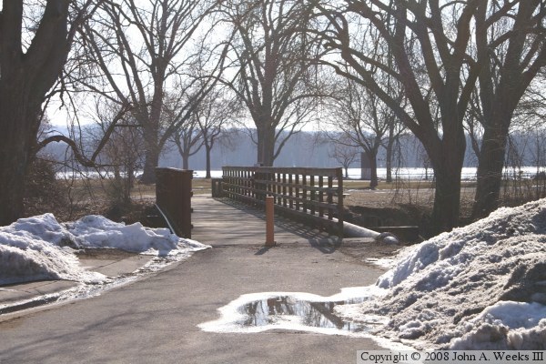
This bridge once carried Market Street onto Isle La Plume from the Wisconsin mainland at La Crosse. The Market Street bridge was closed in the early 1980s and this pedestrian bridge and bicycle path bridge was built using the abutments and piers of the former road bridge. I have not yet learned when the original bridge was built, or when the pedestrian bridge conversion was completed. The bridge deck is just wide enough for a car to cross the Isle La Plume Slough, so the city installed the orange posts to keep vehicles off the bridge. The Market Street bridge had a wooden deck that was covered with blacktop in its latter years. There were raised wooden sidewalks on each side of the roadway with wooden rails. The pipe on the current bridge carries waste water from the City Brewery to the wastewater treatment plant.

Note—thanks goes to Matt Carlson of carlsonphotos.net for filling in the details on this bridge.


Isle La Plume Foot Bridge

Made With Macintosh
Authored by John A. Weeks III, Copyright © 1996—2016, all rights reserved.
For further information, contact: john@johnweeks.com