The Milwaukee Road built a bridge across the Mississippi River in 1874 at
Prairie du Chien and operated trains along the west bank of the Mississippi
River into the Twin Cities. The Milwaukee Road then desired to construct a
rail line into Eau Claire, Wisconsin. This new line would branch off of the
mainline on the west side of the Mississippi River just north of Wabasha at a
small river community known as Reeds Landing. The route would cross the
Mississippi River and skirt the south bank of the Chippewa River for about
40 miles entering Eau Claire from the southwest.
The river crossing used a very interesting bridge style known as a pontoon
bridge. The center span of the bridge was built on a series of boats. When
river navigation traffic wished to pass the bridge, the floating span was
disconnected from the Wisconsin end of the crossing and pulled out of the
way by a tug boat. The Milwaukee Road had two other pontoon bridges,
including an 8,000 foot long bridge over the Mississippi River at Prairie du
Chien and a bridge over the Missouri River at Pierre, South Dakota.
I have not tracked down definitive information on how the bridge operated
in winter. The story that I have heard is that the bridge would be pulled
out of the water in winter to prevent it from being damaged by river ice.
Once the river froze, tracks would be laid across the ice. I do know that
trains did cross the river over the ice, but I find that harder to believe
at this location. The river is narrow at Reeds Landing, meaning that
currents would make the ice dangerous.
The bridge consisted of several different sections. Starting on the
Minnesota side of the crossing, the first section was a 700 foot long
causeway that branched off of the northwest heading mainline and arced
45 degrees towards the north. Next, a 1,050 foot pile trestle, a 105
foot long pony truss span, and 258 additional feet of trestle carried trains
to the south end of the pontoon span. On the east side of the pontoon span,
there was a 40 foot long steel girder span and 1,011 feet of wood pile trestle.
From there, a 7,200 foot causeway crossed river flats to reach the current day
Burlington Northern Santa Fe tracks, and another 2,500 feet of causeway
carried the tracks to the current day location of highway WI-35. North of
highway WI-35, the tracks followed the river bottoms along the Chippewa River
to Trevino, Durand, and into Eau Claire. The pontoon span was 400 feet long.
The Milwaukee Road Pontoon Bridge opened in July, 1882. It was abandoned
in 1952. The causeway between the river and the BNSF tracks was abandoned
at that time. The line to Eau Claire was in use until January, 1977, when
a derailment caused significant damage to the tracks. Milwaukee
Road trains reached the line by crossing a bridge at Winona, and using the
BNSF tracks to reach the causeway near WI-35. Little of the pontoon bridge
still survives. The embankment on the Minnesota side of the river is still
in place. None of the bridge remains. The river is higher today due to
the lock and dam projects. Material dredged from the river channel has
been dumped across the path of the bridge on the Wisconsin side of the
main channel forming a large island. The causeway on the Wisconsin side
of the river is visible on maps, but areas are washed out, making it
difficult to follow on the ground. The connector from the BNSF tracks is
easy to walk to and is readily visible. A section of railroad tracks
crossed WI-35 until relatively recently, perhaps into the early 2000s. A
wooden trestle still stands just north of WI-35.
Update—rail fan Terry Yust tells me that the Pontoon Bridge was rebuilt
three times due to damage from ice. It was dealt a final blow from ice in
April, 1951, which lead to its abandonment. Terry includes an article on the
Pontoon Bridge and the rail line to Eau Claire on the web site for the
Chippewa Valley Motor Car Association.
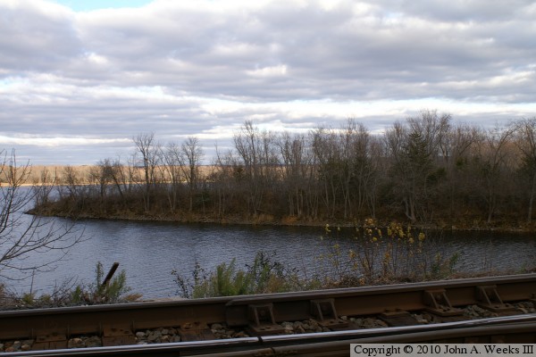
The photo above is a finger of land that is an embankment that curves off
into the Mississippi River that once supported the west end of the pontoon
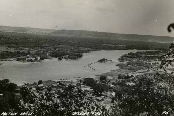
bridge. The photo below is a historic photo that shows the pontoon bridge
from 1916. The view is looking southeast from the bluffs on the Minnesota
side of the Mississippi River.
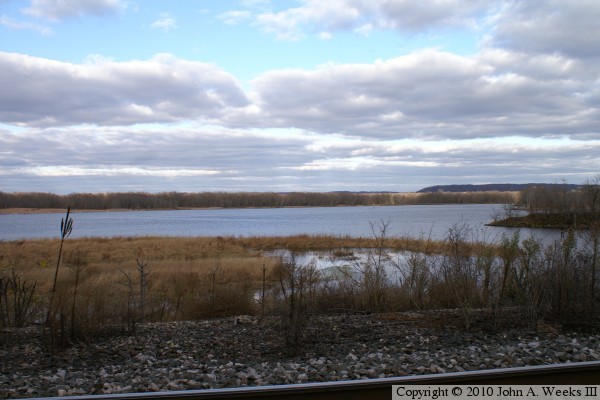
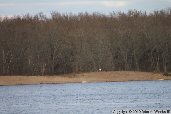
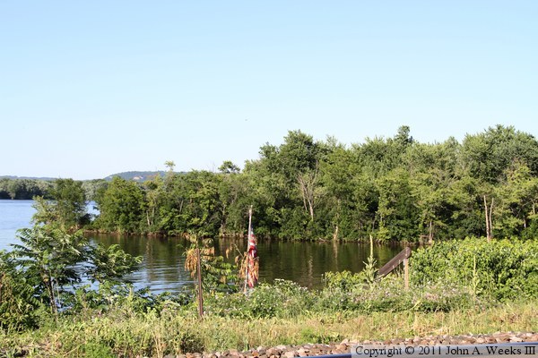
The photo above is looking southeast across the main channel of the
Mississippi River from Reeds Landing where the Milwaukee Road Pontoon Bridge
once stood. The photo below is a close view of the east shore of the river
where the bridge entered Wisconsin.
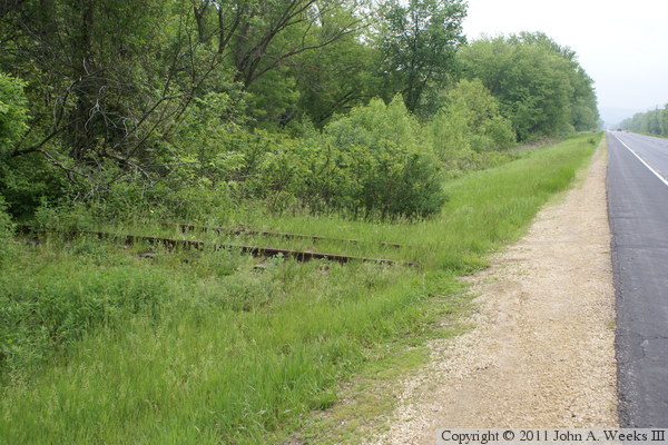
These two photos are summer views of the remaining part of the causeway on
the Minnesota side of the Mississippi River. The photo above is the tip
of the causeway as seen from the road that runs through Reeds Landing.
The photo below is a wider view from along the edge of the CP Rail tracks.
While CP Rail has ‘No Trespassing’ signs posted at close intervals
along the railroad track, local residents still maintain docs on the river
side of the railroad right of way.
The photo above is a sign posted in a parking area near where the Milwaukee
Road tracks formerly crossed Wisconsin highway WI-35. The photo below are
the tracks on the north side of WI-35.
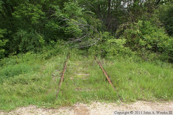
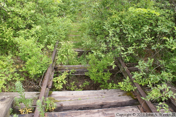
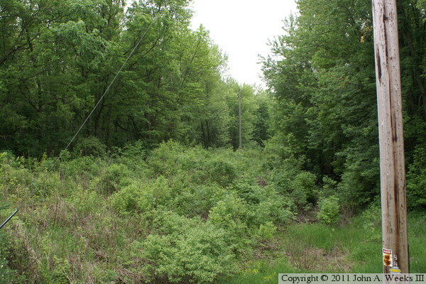
The photo above are the Milwaukee Road tracks heading north into the woods
from highway WI-35. The photo below is a view from just past the treeline
in the woods. While the ties are still in place, they are pretty well
rotted. I find it unusual that the rails were not salvaged given the
recycle value of steel.
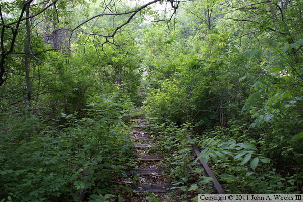
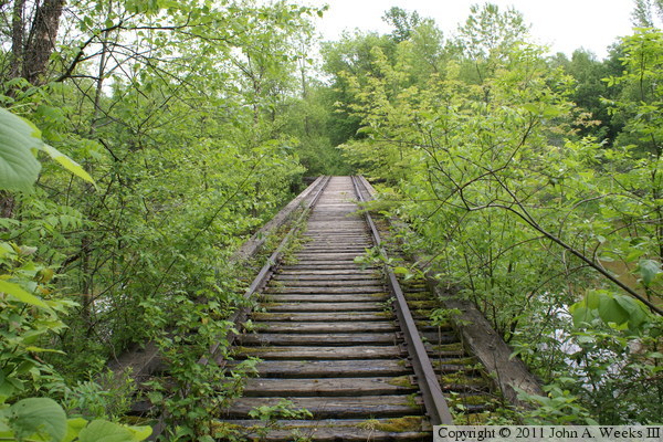
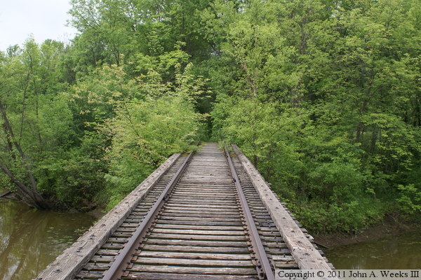
These two photos are looking north across the railroad trestle that is
located just north of highway WI-35. The photo above is looking down the
length of the trestle deck, while the photo below is from the center of
the trestle.
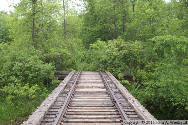
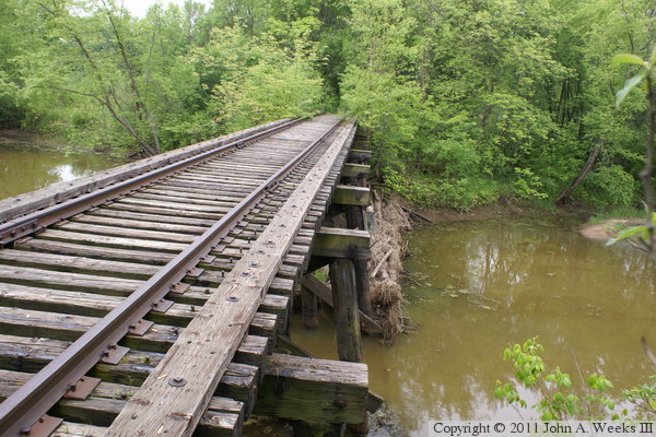
The photo above is looking south down the length of the trestle deck.
The photo below is a closer view of the gap in the ties at the north end
of the trestle. It appears that the approach to the trestle has washed
out, a few ties have fallen down into the washout, and a few more ties are
rotted to the point of being ready to fall off of the rails.
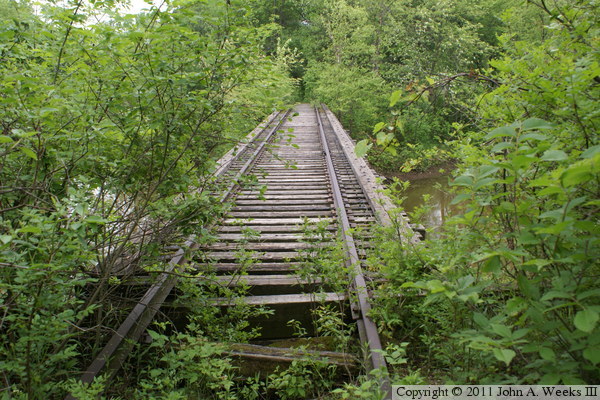
These two photos are views looking south along the deck of the trestle.
The photo above is looking down the center of the trestle deck, while the
photo below is looking over the west edge of the trestle.
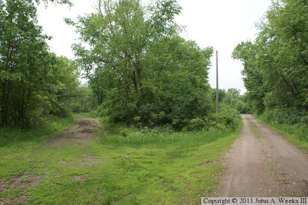
The photo above is looking south down the railroad right of way from highway
WI-35. The main channel of the Mississippi River is two miles to the south,
but most of these two miles are across the Chippewa River delta. The
photo below is a view from the access road leading to Trevino Junction
where the Milwaukee Road tracks from the Pontoon Bridge crossed the
Chicago, Burlington, & Qunicy tracks (now part of BNSF). This road
follows the old railroad right of way for several hundred feet. The
muddy road to the left is a 90 degree curve for an interchange track between
the Milwaukee Road tracks and the CB&Q tracks.
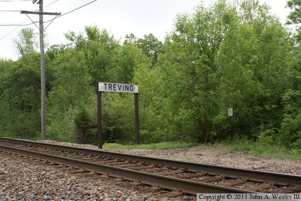
The photo above is a sign for Trevino Junction. The Milwaukee Road
tracks crossed the CB&Q at this location. The small white sign at
the edge of the woods is located about where the railroad tracks were
once located. The photo below is looking directly south into the woods
where the tracks once lead to the Pontoon Bridge. The small sign marks
the edge of a wildlife refuge. The right of way is very overgrown. It
might be possible to walk about one-third of the way towards the Mississippi
River during low water, and in the fall after the leaves drop off of the
trees and brush.
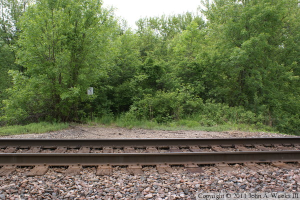
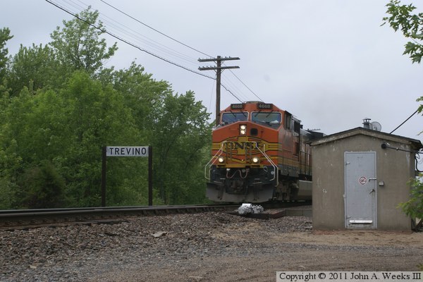
The photo above is looking towards the west at Trevino Junction. The
mechanism next to the tracks is a switch heater. It blows hot air on
the switch to keep it clear of ice in the winter. The switch is for
a siding located east of this location. The photo below is a train
passing Trevino southbound. The rear of the train is still moving downhill
into the Chippewa River valley, which allows the head of the train to
approach fast and quiet.