Current Weather Conditions
John A. Weeks III
Monday, May 6, 2024, 11:15:37 AM CDT
Home Photo Tours Rail Fan 12 Easy Steps
Aviation Spacecraft Highways & Bridges About The Author
 
Google Search
Maps   Groups   Images   Search
 
  Home
  • 12 Easy Steps
  • Aviation
  • Spacecraft
  • Highways & Bridges
    » Bridge Photography
      - MSP River Bridges
      - C & D Canal
      - Illinois River
      - Minnehaha Creek
      - Minnesota River
      - Mississippi River
        › Lake Itasca Area
        › Bemidji Area
        › Cass Lake - Ball Club
        › Grand Rapids Area
        › Blackberry - Crosby
        › Brainerd Lakes Area
        › Little Falls Area
        › St. Cloud Area
        › North Metro Area
        › Port Of Minneapolis
        › St. Anthony Falls Area
        › Mississippi Rvr Gorge
        › St. Paul Area
        › S St. Paul - Hastings
        › Red Wing - Winona
          · Lock & Dam #3
          · Eisenhower Bridge
          · Lloyd Spriggle Mem
          · Lake Pepin Winter Rd
          · Milw Road Pontoon Br
          · Wabasha-Nelson Br
          · Pontoon Slough Br
          · Beef Slough Bridge
          · Buffalo Slough Br
          · Shively Slough Br
          · Lock & Dam #4
          · Lock & Dam #5
          · Lock & Dam #5A
          · Winona Main Channel
          · Winona N Channel Br
          · C&NW Winona Br
          · John A. Latsch Br
          · Winona Bridge Rwy
          · Lock & Dam #6
        › La Crosse Area
        › Lansing - Clinton
        › Quad Cities Area
        › Muscatine - Louisiana
        › St. Louis Area
        › Chester - Cairo
        › Miss - Tenn - Ark
        › Ark - Miss - Louisiana
        › Louisiana Structures
      - Missouri River
      - St. Croix River
      - St. Louis River
      - Wisconsin River
      - Best Miss River Photos
      - Cable Stayed Bridges
      - McGilvray Road Bridges
      - I-35W Bridge Disaster
      - Miscellaneous Bridges
      - Madison County Bridges
      - Hist Br Weekend 2013
    » Road Geek Topics
  • Photo Tours
  • Rail Fan
  • About The Author
 
Site Search By JRank
Highways, Byways, And Bridge Photography
Lloyd Spriggle Memorial Bridge
US-63 Mississippi River Crossing At Red Wing
Red Wing, Minnesota

Lloyd Spriggle Memorial Bridge

• Structure ID: NBI B47002300000000.
• Location: River Mile 792.6.
• River Elevation: 667 Feet.
• Highway: US-63.
• Daily Traffic Count: 11,310 (2003).
• Bridge Type: Steel Girder Concrete Deck.
• Length: 739 Feet Overall, 150 Foot Longest Span.
• Width: 30 Feet, 2 Lanes.
• Navigation Channel Width: 140 Feet.
• Height Above Water: 18 Feet.
• Date Built: Opened September 1960.
The Lloyd Spriggle bridge crosses the Wisconsin Channel of the Mississippi about 2 miles north of Red Wing, Minnesota. The river in this area is rather wide, sometimes 2 miles wide, often with two distinct channels and large areas of wetlands. The Minnesota Channel is the main river navigation channel, so this bridge only needs to be high enough for pleasure craft to pass under.

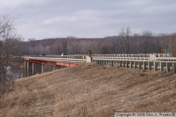
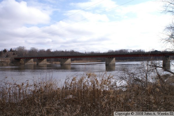
The bridge girders are painted a very attractive bright red. This is a welcome change from the typical silver, blue, and green bridge structures that are so common in this area. It is named after Lloyd Spriggle, long time area resident, and a leader in efforts to clean up the environment and protect river water quality.


Lloyd Spriggle Memorial Bridge

Made With Macintosh
Authored by John A. Weeks III, Copyright © 1996—2016, all rights reserved.
For further information, contact: john@johnweeks.com