Current Weather Conditions
John A. Weeks III
Thursday, May 2, 2024, 4:23:22 PM CDT
Home Photo Tours Rail Fan 12 Easy Steps
Aviation Spacecraft Highways & Bridges About The Author
 
Google Search
Maps   Groups   Images   Search
 
  Home
  • 12 Easy Steps
  • Aviation
  • Spacecraft
  • Highways & Bridges
    » Bridge Photography
      - MSP River Bridges
      - C & D Canal
      - Illinois River
      - Minnehaha Creek
      - Minnesota River
      - Mississippi River
        › Lake Itasca Area
        › Bemidji Area
        › Cass Lake - Ball Club
        › Grand Rapids Area
        › Blackberry - Crosby
        › Brainerd Lakes Area
        › Little Falls Area
        › St. Cloud Area
        › North Metro Area
        › Port Of Minneapolis
        › St. Anthony Falls Area
        › Mississippi Rvr Gorge
        › St. Paul Area
        › S St. Paul - Hastings
        › Red Wing - Winona
          · Lock & Dam #3
          · Eisenhower Bridge
          · Lloyd Spriggle Mem
          · Lake Pepin Winter Rd
          · Milw Road Pontoon Br
          · Wabasha-Nelson Br
          · Pontoon Slough Br
          · Beef Slough Bridge
          · Buffalo Slough Br
          · Shively Slough Br
          · Lock & Dam #4
          · Lock & Dam #5
          · Lock & Dam #5A
          · Winona Main Channel
          · Winona N Channel Br
          · C&NW Winona Br
          · John A. Latsch Br
          · Winona Bridge Rwy
          · Lock & Dam #6
        › La Crosse Area
        › Lansing - Clinton
        › Quad Cities Area
        › Muscatine - Louisiana
        › St. Louis Area
        › Chester - Cairo
        › Miss - Tenn - Ark
        › Ark - Miss - Louisiana
        › Louisiana Structures
      - Missouri River
      - St. Croix River
      - St. Louis River
      - Wisconsin River
      - Best Miss River Photos
      - Cable Stayed Bridges
      - McGilvray Road Bridges
      - I-35W Bridge Disaster
      - Miscellaneous Bridges
      - Madison County Bridges
      - Hist Br Weekend 2013
    » Road Geek Topics
  • Photo Tours
  • Rail Fan
  • About The Author
 
Site Search By JRank
Highways, Byways, And Bridge Photography
Buffalo Slough Bridge
MN-60/WI-25 Mississippi River Crossing At Wabasha
Wabasha, Minnesota

Buffalo Slough Bridge

• Structure ID: NBI B06002000000000.
• Location: River Mile 760.2.
• River Elevation: 667 Feet.
• Highway: MN-60, WI-25.
• Daily Traffic Count: 5,300 (2002).
• Bridge Type: Steel Girder Concrete Deck.
• Length: 407 Feet Overall, 67 Foot Main Span.
• Width: 28 Feet, 2 Lanes.
• Navigation Channel Width: 64 Feet.
• Height Above Water: 8 Feet.
• Date Built: Opened 1955, Rebuilt 1991.
There are five bridges as part of the Wabasha-Nelson Mississippi River crossing. The main channel bridge is at the state line. The Buffalo Slough Bridge is the third causeway bridge heading east from Minnesota, and it is located one mile and five tenths east of the state line.

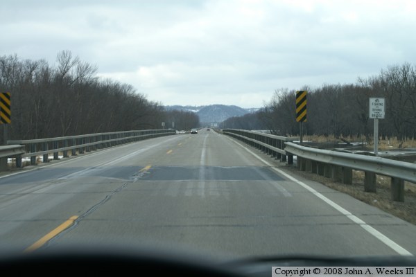
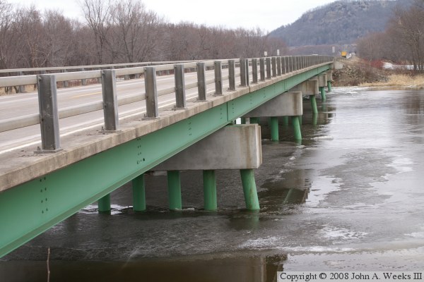
The bridge steel structure is painted green, which is a nice addition of color to an otherwise industrial-looking structure.


Buffalo Slough Bridge

Made With Macintosh
Authored by John A. Weeks III, Copyright © 1996—2016, all rights reserved.
For further information, contact: john@johnweeks.com