| Highways, Byways, And Bridge Photography |
The I-35W Bridge Lit Up In Gold
A Look At The I-35W Saint Anthony Falls
Bridge Lit Up In Gold For Childhood Cancer
Awareness Month On September 27, 2012

The new I-35W Saint Anthony Falls Bridge features an innovative LED lighting
system where each LED element is individually addressable, allowing any
color in the spectrum to be displayed. On most nights, the bridge is bathed
in a eerie blue glow that looks like something out of a science fiction movie.
However, the bridge is occassionaly lit up in other colors for special
occasions.
While most people are aware of the pink ribbon and efforts to cure
breast cancer, the gold ribbon for childhood cancer is less well known.
In fact, I was not aware of gold ribbon until I was alerted to the I-35W
bridge light show for Childhood Cancer Awareness Month by a news producer
from KARE-11 TV. Local advocates for the gold ribbon campaign petitioned
MN-DOT to light up the I-35W bridge in gold. The event was staged on
Thursday, September 27, 2012. Supporters met at the parking lot in
Bohemian Flats to hold a candle light vigil and a balloon release, then
made the trek up the hill to see the bridge up close. The weather
cooperated nicely with 60 degree temperatures and almost no wind. That
made for still water resulting in some very nice reflections off of the
surface of the Mississippi River.
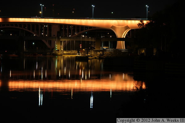
The photo above is looking downstream towards the west face of the I-35W
Saint Anthony Falls Bridge as seen from the edge of the boat channel at the
downstream exit of the Upper Saint Anthony Falls Lock & Dam. A slight
curve in the boat channel makes it look like these photos were taken from
the middle of the river. The structure in front of the right set of
main bridge piers is the boat lock for the Lower Saint Anthony Falls
Lock & Dam. If you look closely, you can see a barge just starting
to exit the lock coming upstream towards our vantage point.
Note—these materials are covered by copyright and may not be
used without written permission.

The photo above is looking north across the Mississippi River along the
downstream east face of the I-35W Saint Anthony Falls Bridge. This photo
was taken from my favorite vantage point located on the top of the river
bluffs while standing under the edge of the nearby 10th Avenue Bridge. This
is the only public view of the bridge from an elevation close to the level
of the traffic deck.
The photo below is also looking north across the Mississippi River, but
from the edge of West River Parkway just upstream of the structure. The
trees that were planted after the bridge opened are starting to get large
enough to block the view, resulting in the north main bridge piers being
hidden behind the leaves. The observation deck on the north side of
the river is lit up at night, but it is not yet open to the public.


These two photos are nearly identical views of the downstream face of the
main river navigation channel span. The only difference between these photos
is the ISO speed of the camera sensor. The photo above is taken at ASA800,
while the photo below was taken at ASA100. While the bridge looks exactly
the same, the surface of the water is different. Ripples on the surface
are visible in the upper image due to the higher ISO speed allowing for a
much shorter exposure time. In the image below, the longer exposure time
causes the ripples to be blurred. Note that the malfunctioning modules in
the lighting controller still has not been fixed, resulting in a section
of the bridge being stuck on blue, and a few segments of the LED lighting
system being dark.


The photo above is another view of the main river channel span. This view is
from the sidewalk on the north side of West River Parkway, which runs along
the south and west riverbank. The photo below is taken from the bicycle
path on the south side of West River Parkway. The image is centered on
the south main bridge piers. Note that another glitch in the lighting
controller is causing extra blue light to show up on the second pier
from the right.


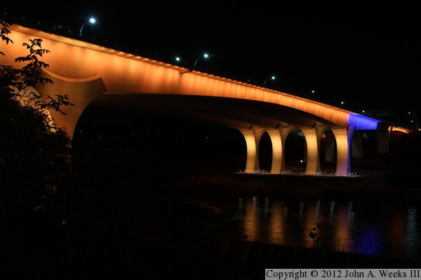
The photo above is looking north across the Mississippi River along the
downstream edge of the structure. We can see how the LED lights are
installed on the outside edge of the bridge deck and shine inward towards
the bridge structure. The photo below is looking north across the
Mississippi River from directly below the gap between the two parallel
bridge spans. The fence in the foreground is the railing for the path
leading down to the observation deck, which is visible under the main
bridge piers. The south observation deck is open 24 hours per day.


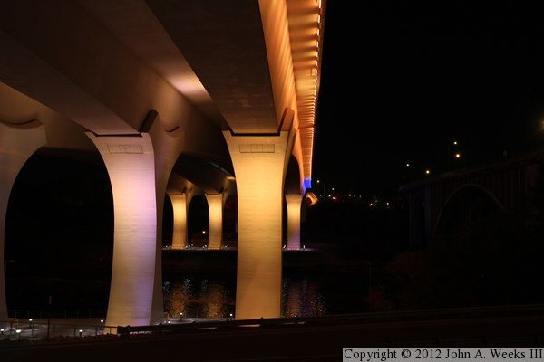
These two photos were taken from the south riverbank in Mill Ruins Park,
located just upstream from the I-35W bridge. The photo above shows
about 80% of the bridge structure. Much of the south secondary span
is obscured by trees from this vantage point. The water was very still
on this evening, resulting in a nice reflection.
The photo below is
a close view of the south main bridge piers from the same vantage point.
The structure in front of the piers is the boat lock that is part of
the Lower Saint Anthony Falls Lock & Dam. This photo is a little
overexposed to allow the lock structure to show up a little better.
One can also faintly see the 10th Avenue Bridge in the background.
That structure is not lit up, but the glow from the I-35W bridge makes
it visible in this long exposure image.

|

