| Highways, Byways, And Bridge Photography |
The I-35W Bridge Prince Tribute
A Look At The I-35W Saint Anthony
Falls Bridge Lit Up In Purple As A Tribute
To Prince On April 21, 2016

Prince Rogers Nelson, a Twin Cities native and music legend, was found
unresponsive at his studio in Chanhassen, MN, on the morning of Friday,
April 21, 2016. He was pronounced dead when paramedics were unable to
revive him. The loss was sudden and stunning given his relatively young
age. Tributes and memorials were created as quickly as the news spread
across the region.
At 1:23 PM, MN-DOT announced via Twitter that they would light up the I-35W
Saint Anthony Falls Bridge in purple for the evening. Their tweet read:
#RIPPrince The I-35W Bridge will reign purple tonight
Shortly thereafter, Governor Mark Dayton directed MN-DOT to keep the bridge
tribute going through the weekend. Word of the tribute light display spread
by both social media and conventional media. When I arrived shortly after
dark, there were already long lines of vehicles backed up along West River
Road in both directions. There is no parking area on the south side of the
bridge, and the road going to the Lock & Dam is closed off for a
construction project, so cars were simply stopping in the traffic lane.
Minneapolis Police officers arrived within the hour and started controlling
the situation to help keep traffic crawling past the bridge. Meanwhile, some
folks drove down onto the river flats area on the north side of the river.
That is typically OK during the daytime but is not welcome after dark.
Officers responded and cleared a number of vehicles from that area as I
watched from Northern Pacific Bridge #9.
All in all, the bridge light display was very successful. It had, by far,
the most visitors of any light display that I have seen so far. It
received nationwide TV coverage and extensive coverage on social media.
Unfortunately, most of the photos were of pretty low quality since a
typical cellular telephone camera doesn't do well capturing lights at
night. The few photos that were of higher quality were taken with digital
SLR cameras, with the best coming from people shooting in manual mode
using a tripod. My photos were taken with a Cannon 7D in manual mode.
I shot them at ISO 200 (a relatively slow speed) at F2.8, and bracketed
the shutter speed from 1/20 second all the way to 10 seconds, with the
best results typically between 1/2 second and 1 second.
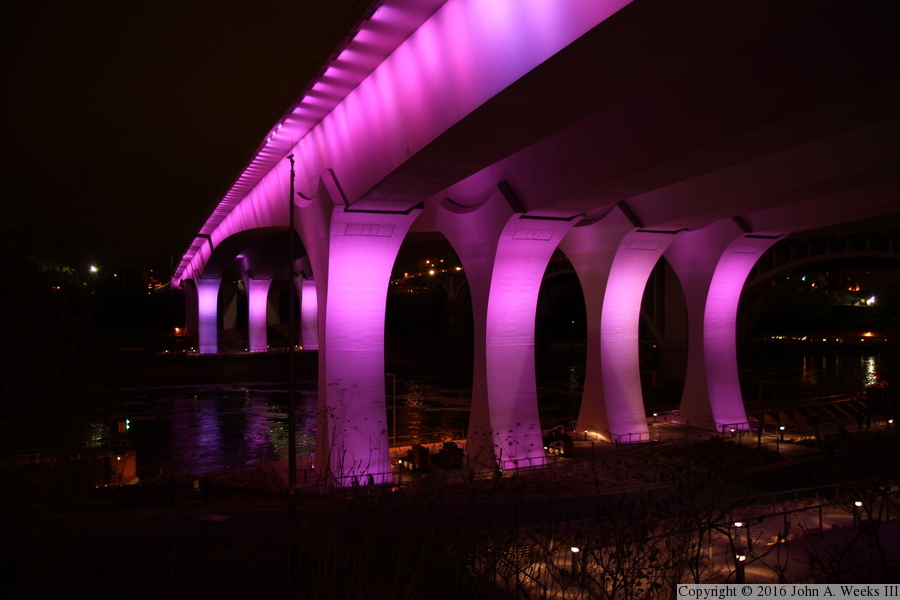
The photo above is the downstream east face of the Saint Anthony Falls Bridge
as seen from West River Parkway, the road that runs along the west bank of
the Mississippi River. I was hoping for a little darker color of purple.
Many photos show a deeper color, but this photo is closer to what it actually
looked like. Other photos had the exposure adjusted to deepen the color,
and some early images shown in the media were actually Photoshop creations
rather than real photographs.
Note—these materials are covered by copyright and may not be
used without written permission.
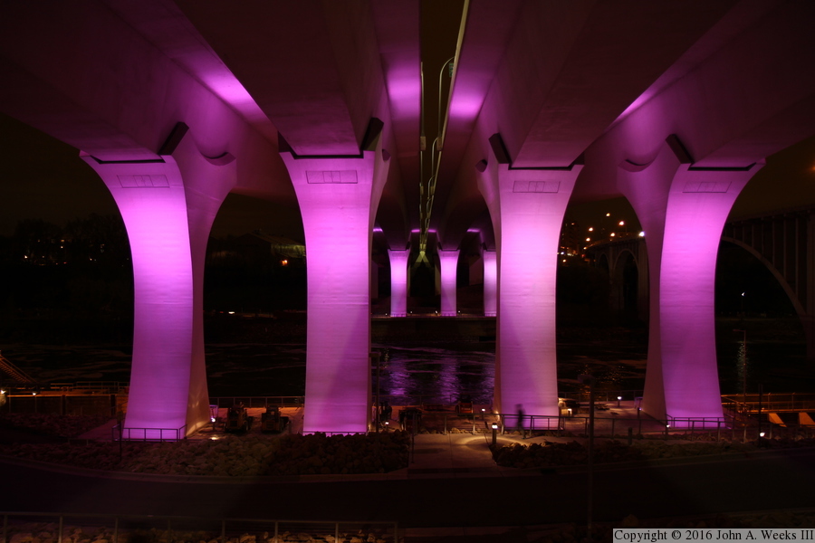
The photo above is the upstream west face of the Saint Anthony Falls Bridge
as seen from the south riverbank. The vantage point is standing in the brush
just off of the bicycle trail that runs along the south riverbank. This area
is usually filled with brush and trees, but this view was relatively clear
given that trees and brush did not yet have leaves this early in spring.
This view is looking north across the Mississippi River from directly under
the gap between the two parallel bridge spans. The observation deck is
visible under the closer of the two sets of main bridge piers. There is an
observation deck under the main bridge piers on the north side of the river,
but it has never been open to the public.

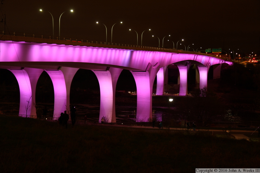
This view is looking north across the Mississippi River along the downstream
east face of the I-35W bridge. The vantage point is on the bluff located just
south of West River Road. There is no official trail going up the bluff,
but it is a fairly easy climb. Notice that the guard rail on top of the bridge
deck is lit up by car headlights from traffic on the structure. This is
surprisingly difficult to capture, but it turned out well in this photo.
Perhaps that is a little bit of purple magic in action.
This is another view from the top of the bluffs located on the south side
of the Mississippi River. This is a wider shot than the previous view that
shows the full length of the structure. There is no good place to get a
profile view of the bridge due to obstructions, such as the nearby 10th
Avenue Bridge, so this is about as wide angle of a view that is possible.
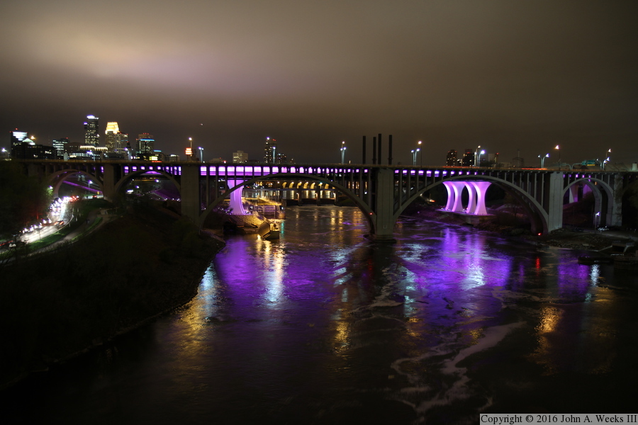
These two photos are views from the deck of the nearby Northern Pacific
Bridge #9, an old railroad bridge that was converted into a bicycle and
pedestrian trail. The 10th Avenue Bridge obscures the I-35W bridge, but
it also adds a nice effect in the pattern created by the concrete
structural members of that bridge blocking the light from the I-35W bridge.
Even more spectacular is the reflections of the purple light on the surface
of the Mississippi River. The photo above is a wide angle shot, while the
photo below is focused on the downtown Minneapolis skyline. Note the line
of cars on West River Road on the left side of each photo.

|
