| Highways, Byways, And Bridge Photography |
The I-35W Bridge In The Pink
A Look At The I-35W Saint Anthony Falls Bridge
Lit Up In Pink To Raise Awareness For
Breast Cancer On October 14, 2011

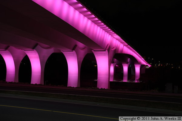
The new I-35W Saint Anthony Falls Bridge features an innovative LED lighting
system where each LED element is individually addressable, allowing any
color in the spectrum to be displayed. On most nights, the bridge is bathed
in a eerie blue glow that looks like something out of a science fiction movie.
However, the bridge is occassionaly lit up in other colors for special
occasions.
MN-DOT lit up the bridge in safety orange on April 28, 2011, for Workers
Memorial Day. I was out of town that day, so I missed it.
On June 25, 2011, the I-35W bridge was lit up in a rainbow pattern for the
Twin Cities Pride Festival. The media reported the wrong dates for the
bridge lights, and as a result, I missed that event. On the night of
September 11, 2011, the bridge was lit up in a patriotic red, while, and
blue pattern. That wasn't announced in advance, so I also missed that
event. However, MN-DOT got the word out for the breast cancer awareness
event, and it was widely reported in the newspaper and on TV news. These
photos of the I-35W bridge glowing bright pink were taken on October 14,
2011, and due to the MN-DOT publicity, I was finally able to see the bridge
lit up in some color other than blue.
The photo above is looking downstream towards the I-35W Saint Anthony Falls
Bridge from the deck of the nearby Stone Arch Bridge. The Lower Saint
Anthony Falls Lock & Dam is located in front of the bridge, with the
boat lock being on the right side of the photo. This photo was taken with
a long exposure to reveal the structures near the bridge and highlight the
pink reflections.
Note—these materials are covered by copyright and may not be
used without written permission.

The photo above is the same view as above, but with a much shorter exposure
time. It shows the true color of the pink light. The bottom of the piers
are somewhat obscured by the lock and dam structure.

This photo is the upstream side of the I-35W bridge. The vantage point is a
small clearing along the sidewalk on the West River Parkway. This view is
often much more obstructed by leaves, but a strong wind had blown most of
the leaves off of the trees early in the fall colors season.

This photo is the downstream side of the I-35W bridge. The vantage point
is the south side of the West River Parkway about halfway between the I-35W
bridge and the 10th Avenue Bridge.

This is another view of the downstream face of the I-35W Saint Anthony Falls
Bridge. The vantage point is high on the bluffs near the 10th Avenue
Bridge on the south side of the river. This location can be accessed from
a small parking area on South 1st Street, or by climbing the embankment
from West River Parkway.

This view is looking north across the Mississippi River from the observation
deck located under the south end of the I-35W bridge. There is a similar
observation deck on the north side of the river, but it is not yet open to
the public as of 2011. There is a second set of piers behind the main bridge
piers that is partially obscured by a large gravel pile that is part of a
sewer line project just downstream of the bridge site. The light located at
the far end of the bridge between the two bridge spans is the monument on
the north end of the bridge. The river is about 430 feet wide at this
location.

This is one of the light panels located at the base of a main bridge pier.
The panels are made up of large LED lamps. They are arranged in a series
with red, blue, and green lamps. A computerized controller can address
each lamp individually, allowing for any color in the spectrum to be
created. Panels at the base of the piers light up the piers, while panels
along the edge of the bridge spans light up the sides of the structure.

This view is looking downstream to the east towards the bridge span over
the West River Parkway. The red streak is tail lights from a passing
vehicle. The blue lights of the bridge monument at the south end of the
bridge is just barely visible at the right end of the bridge span.

This photo is a close view of the main bridge span as seen from the Stone
Arch Bridge. The I-35W bridge is about 2,500 feet to the east of the spot
where I took this photo.

This photo is a view from the south bank of the Mississippi River. The vantage
point is along the access road that runs through Mill Ruins Park. There
would normally be a fairly large reflection of the bridge on the water, but
on this night, high winds created a very choppy water surface, which
prevented seeing a reflection.

These two photos are the exact same view taken with two different exposure
times. The photo above is a shorter exposure that shows the true color of
the pink light. The photo below has a much longer exposure, which allows
one to see the details of the lock and dam located just upstream of the
bridge. The vantage point is the access road leading to the upstream side
of the Lower Saint Anthony Falls Lock & Dam. Note the city light
reflecting off of the clouds. The photo at the top of this page was taken
about an hour later after the clouds had moved out of the area, resulting
in a totally different look to the night sky.

|

