| Highways, Byways, And Bridge Photography |
Leonard P. Zakim Bunker Hill Memorial Bridge
I-93/US-1 Charles River Crossing At Boston
Boston, Massachusetts
| |
• Bridge: |
Leonard P. Zakim Bunker Hill Memorial Bridge |
| |
• Structure ID: |
NBI B166009PMMHSNBI |
| |
• City: |
Boston |
| |
• State: |
Massachusetts |
| |
• Country: |
USA |
| |
• Carries: |
I-93/US-1 |
| |
• Crosses: |
Charles River |
| |
• Date Opened: |
March 30, 2003 |
| |
• Total Length: |
1,432 Feet |
| |
• Longest Span: |
745 Feet |
| |
• Tower Height: |
295 Feet (South Tower), 323 Feet (North Tower) |
| |
• Deck Width: |
183 Feet |
| |
• Number Of Lanes: |
10 |
| |
• Number Of Spans: |
1 |
| |
• Height Above Water: |
40 Feet |
| |
• Traffic Count: |
206,260 (2008) |
| |
The rise of the automobile culture after World War II left Boston with a huge
traffic problem. Its centuries old layout and awkward geography left traffic
choked in a tangle of narrow and crooked streets that threatened to leave the
city behind as the world rocketed towards the space age. The savior for the
city was envisioned to be the Interstate Highway project, with its local
centerpiece, the I-93 Central Artery, an elevated double-deck steel freeway
through the heart of the city.
Unfortunately, the Central Artery turned out to be a mistake. First, it was
ugly. Locals began to refer to it as the ‘Big Green Monster’, a
reference to the large outfield wall in Fenway Park. Second, it split the
city in two and walled off the historic waterfront. Third, due to poor design,
it did not solve the traffic problem. For example, it mixed north and south
traffic with east and west traffic. It forced some traffic back onto city
streets, which would back up on to the freeway. It had too many ramps, too
few merging lanes, and had an accident rate four times the national average.
Finally, the freeway revolt that lead to the cancellation of the Inner Belt
freeway meant that half of the downtown freeway system was never built. By
1980, congestion was a major problem 6 hours per day, and it was expected to
reach 16 hours per day by 2010.
The solution to the I-93 problem was the Central Artery/Tunnel Project, known
as the ‘Big Dig’. This would replace the elevated I-93 structure
with a tunnel, add a new east-west tunnel to the airport, and knit the city
back together with a linear greenspace on the site of the old elevated
freeway. The north end of the project would include a large bridge over the
Charles River. While most of the Big Dig would be underground and be
invisible from the street, the new Charles River bridge would be very visible,
so it was decided that it would be a signature structure for the city of
Boston. That increased the cost of the bridge by about $30-million, but
that is short money in the context of a $20-billion project.
The Zakim Bridge connects the central core of Boston to the Charlestown
neighborhood. The Charles River is navigable, so a long clear span was
desirable. This is an ideal application for a cable stayed bridge. The final
design was for a 745 foot main span, plus a 267 foot long suspended span
on the Boston end of the bridge and a 420 foot long suspended span on the
Charlestown end of the bridge. The bridge deck would consist of 8 traffic
lanes, four northbound and four southbound, plus two northbound auxiliary
lanes cantilevered off of the east side of the bridge. The resulting bridge
deck is the widest of any existing cable stayed bridge (when this was written
in 2011) at 183 feet wide. The bridge deck has 40 feet of clearance for
navigation traffic.
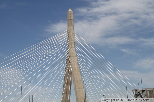
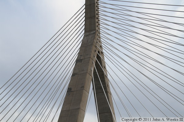
The tower design called for two inverted-Y
towers, with the south tower being 295 feet tall and the north tower at
323 feet. A pair of H-towers might have been less complex, but it would have
been too much of a reminder of supports for I-93 elevated structure that it
was replacing. Using Y-towers allowed for an innovative cable configuration.
The approach spans are supported by the stay cables in the center of the
bridge deck, while the main span is supported from the outside edges of the
bridge deck. Cables are attached to the legs of the towers as well as the
vertical section, resulting in two different V-shapes as cables vee towards
the center of the bridge outside of the towers, and vee towards the towers
over the main bridge span.
Traffic first started using the Zakim Bridge on March 30, 2003 when the four
northbound lanes were opened. The southbound lanes opened on December 20,
2003, and the cantilevered northbound lanes opened in April, 2005. There
is no pedestrian or bicycle access to the structure, but there are excellent
nearby alternatives. The bridge featured an excellent decorative lighting
effect for several years. The lights were turned off on April 9, 2009, as
a cost savings effort during the economic crunch that followed a housing
market collapse.
The bridge was referred to as the Charles River Bridge when it was initially
proposed in the Central Artery/Tunnel Project. It was later intended to
commemorate the Battle of Bunker Hill, which occurred less than one-third of
a mile northeast of the bridge site. In fact, the bridge towers were designed
to look like the nearby Bunker Hill Memorial. The governor of Massachusetts
proposed the name ‘Freedom Bridge’, which later morphed into
‘Bunker Hill Freedom Bridge’. About that time, popular local
community organizer and civil rights advocate Lenorad Paul Zakim passed away
at the young age of 46 after a battle with cancer. Many in the Boston area
lobbied to have the bridge named after Zakim. Eventually, a compromise was
reached, and both Zakim and the Battle of Bunker Hill were honored with the
name ‘Leonard P. Zakim Bunker Hill Memorial Bridge’. In my
visit to Boston, I only heard the bridge referred to as the ‘Zakim
Bridge’.
The merits and outcome of the Big Dig project will be debated for decades,
and it is beyond the scope of my short overview of the Zakim Bridge. There
are no doubts that it was financially mismanaged and construction oversight
was seriously lacking at times. However, one does not have to spend much time
in Boston before realizing that removing the Big Green Monster has lead to a
renaissance in the livability of the city.
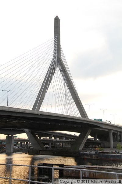
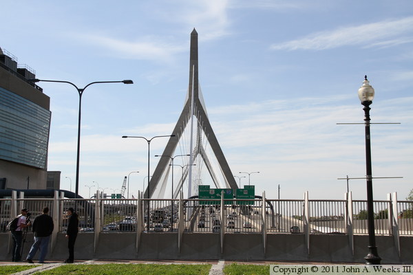
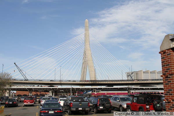
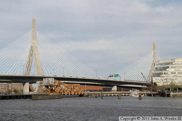
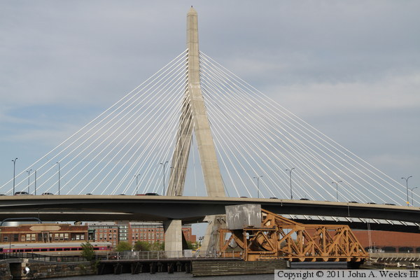
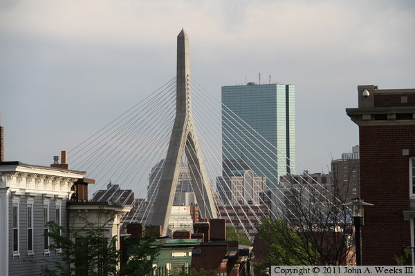
The photo above is looking south towards the Zakim Bridge and downtown Boston
from a pedestrian overpass over New Ruthferford Avenue that leads to the
Community College T-Station. This is the best unobstructed view of the
structure that I was able to find. There is also a good view from the top
of the Bunker Hill Monument, but unfortunately, it was closed for renovation
when I visited in the spring of 2011. The photo below is a closer view
from a slightly different location on this pedestrian overpass.
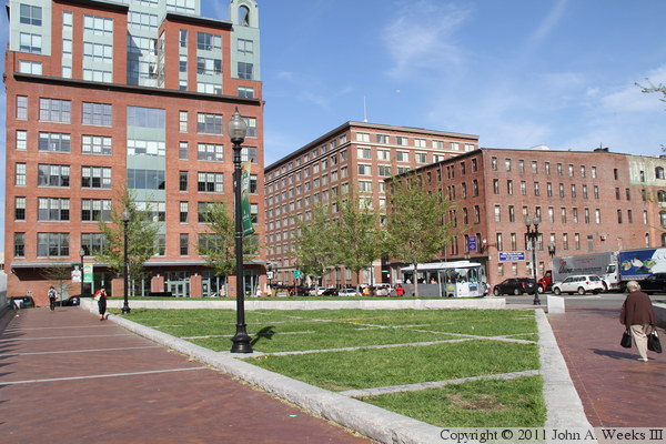
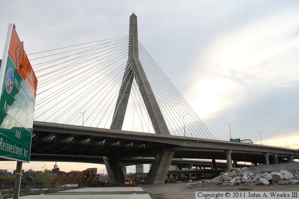
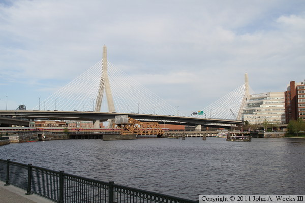
These two photos are views of Portal Park, located at the north end of the
Rose Kennedy Greenway. The greenway is open park space that is built were
the old I-93 structure once cut through the heart of Boston. Portal Park
is on the north end of the Big Dig Tunnel where the highway emerges from
under the city to cross the Charles River. The photo above is looking
east across the park towards the North End district of Boston. The photo
below shows the guard rail over the tunnel entrance.

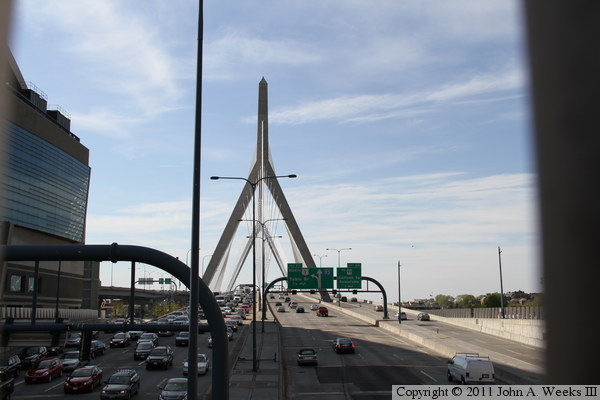
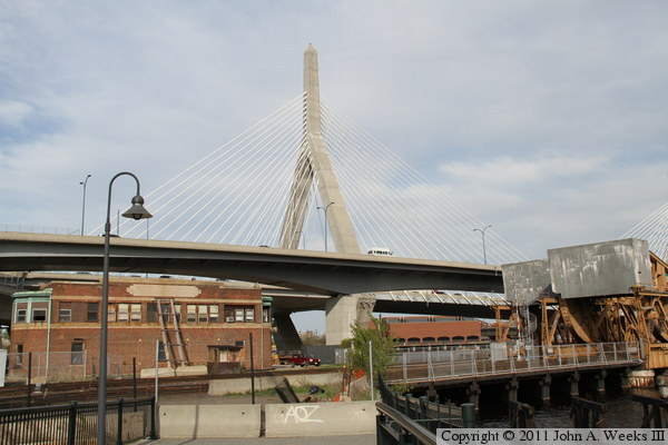
These two photos are views of the Zakim Bridge looking north down the center
of the bridge deck from Portal Park. The TD Garden arena casts a large
shadow across the highway, and the afternoon sun is on the far side of the
bridge, leaving the towers in a shadow. The photo above shows the guardrail
on top of the tunnel portal, while the photo below is looking through the
guardrail. The person on the right is Kevin Cody, a friend who lives in the
Boston area who scouted out the vantage points for this series of photos.
The person on the left was filming stock footage to be used on the NBC TV
series ‘America’s Got Talent.’

These two photos are looking north along the west face of the Zakim Bridge.
The photo above was taken from the west edge of the Big Dig tunnel portal
where Interstate highway I-93 descends underground. The photo below was
taken from the sidewalk running along the east side of the TD Garden arena.
We were not able to walk any further down this sidewalk due to higher levels
of security for a Boston Bruins playoff game that was being played that
evening.

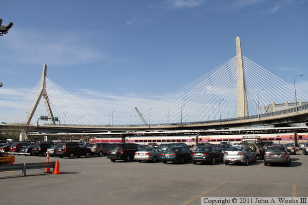
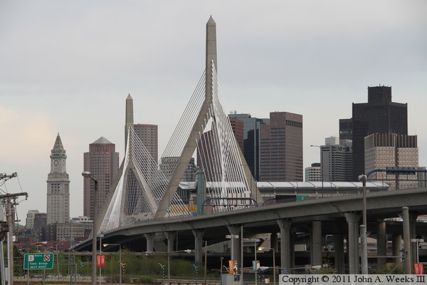
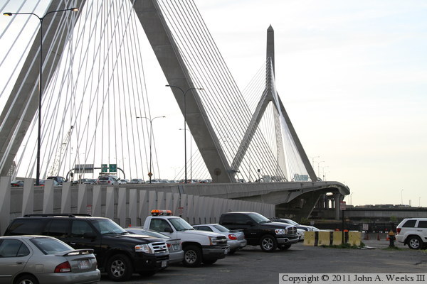
The photo above is looking east towards the Zakim Bridge from a parking lot
located adjacent to North Station, a major transportation hub for Boston.
The photo below is a view of the south bridge tower as seen from the end of
platform #1/#2, which serves MBTA Commuter Rail.

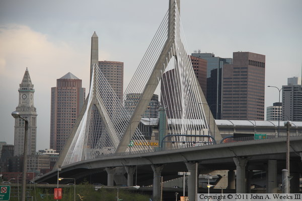
These two photos are looking east towards the south bridge tower from the
parking lot at the Spaulding Rehabilitation Hospital. The photo above is a
view of the cable fan, while the photo below is a closer view of the cable
anchors on the bridge tower.
These two photos are looking east towards the north bridge tower from the
Nashua Street Park, located on the south bank of the Charles River. The
photo above is a view of the cable fan, while the photo below is a close view
of the cables anchors on the bridge tower.

These two photos are views of the Zakim Bridge as seen from North Point Park
on the north bank of the Charles River. The yellow truss bascule located in
front of the north bridge tower carries commuter rail trails out of North
Station and across the Charles River. The concrete highway bridge located
between the rail bridge and the Zakim Bridge carries exit ramps from
Interstate highway I-93 to state highway 3.
These two photos are additional views from North Point Park. The photo
above is a closer view of the north bridge tower, while the photo below
is a closer view of the south bridge tower, which is partially obscured
by the Spaulding Rehabilitation Hospital.
These two photos are additional views of the Zakim Bridge from North Point
Park. They were taken from a waterfront trail that will eventually pass
under the Zakim Bridge and connect to Paul Revere Park on the east side
of the structure.

The photo above is a view of the north bridge tower from the end of the
trail along the edge of the commuter rail line coming out of North Station.
A project is underway to build a bridge to extend this trail across the
rail line, across a small barge channel, and under the Zakim Bridge to
connect to Paul Revere Park. The photo below is a view of the south bridge
tower as seen from a small hill in North Point Park. This location provides
a clear view of the south bridge tower without it being obscured by the
hospital.

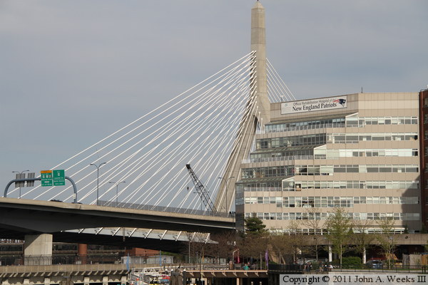
The photo above is the north bridge tower as seen from ground level at the
Bunker Hill Memorial. This view is overlooking the Charlestown neighborhood
of Boston, with the Back Bay area of Boston located on the far side of the
bridge. The tall skyscraper is the 60-story Handcock Place building, known
locally as the John Hancock Tower. This building is famous for problem with
glass falling off of the tower and for swaying so much that people get
motion sickness on the upper floors. The photo below is looking northwest
along the east face of the Zakim Bridge, looking into the evening sun, from
the State Patrol parking lot near the south bridge tower.
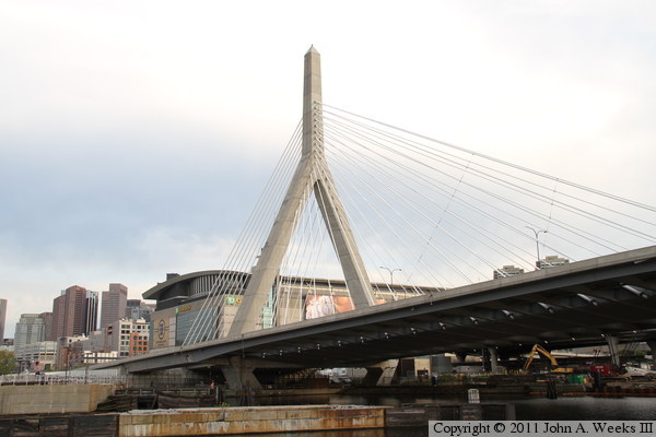
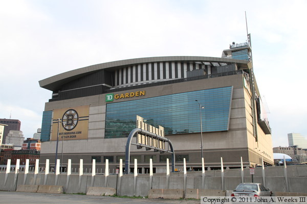
The photo below is looking southwest towards the south bridge tower from
Paul Revere Park. The TD Garden sports arena is located on the far side
of the bridge. The photo below is the TD Garden, located near the south
bridge abutment, home to the Boston Bruins NHL Hockey team, Boston
Celtics NBA Basketball team, and the Boston Blazers NLL Lacrosse team.

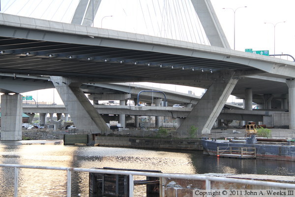
The photo above is looking southwest towards the main bridge span, as seen
from Paul Revere Park. The photo below is looking northeast under the main
bridge span from the Charles River Locks, a lock and dam system and
hydroelectric power plant on the Charles River. Sunlight reflecting off of
the river helps to illuminate the underside of the bridge, revealing some
of the structural details.

The photo above is looking northwest towards the north bridge tower from the
Charles River Locks. The photo is underexposed to make visible some of the
details under the bridge deck. The locks are interesting in their own right,
with a walkway that allows one to cross the three ship locks and pass over
the intakes to the hydro plan. The photo below is another view of the south
bridge tower looking into the late evening setting sun.
The photo above is looking northwest towards the north bridge tower from
Paul Revere Park. The debris in the foreground is left over from the
former I-93 metal bridge that spanned the Charles River prior to the Big
Dig project. This area is being cleared to develop it into a park, with
a pedestrian bridge connecting to North Point Park. The photo below is
a close view of the cable attachments to the south bridge tower.

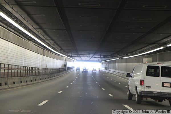
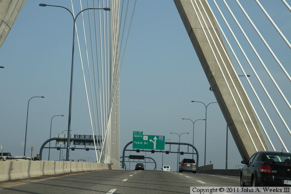
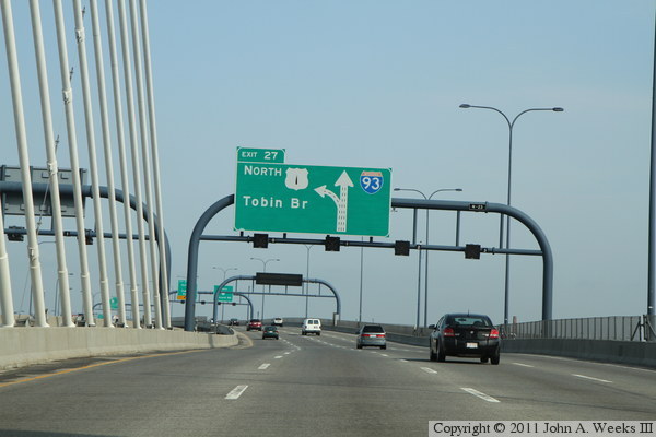
These two photos, and the six that follow, show a typical crossing of the
Zakim Bridge heading northbound. In the photo above, we are exiting the
Interstate highway I-90 Ted Williams Tunnel and entering the I-93 Central
Artery tunnel. In the photo below, we are nearing the north tunnel portal,
where we will emerge on the Zakim Bridge.
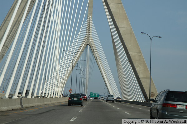
These two photos continue our northbound bridge crossing. In the photo above,
we have just exited the Central Artery tunnel and have entered the south end
of the Zakim Bridge. In the photo below, we are approaching the south
bridge tower. The cable configuration is readily visible in this photo.
Cables on the outsides of the tower connect to the center of the bridge
deck, while cables located between the towers connect to the sides of the
bridge deck. This is the only major cable stayed bridge that has this
style cable configuration.
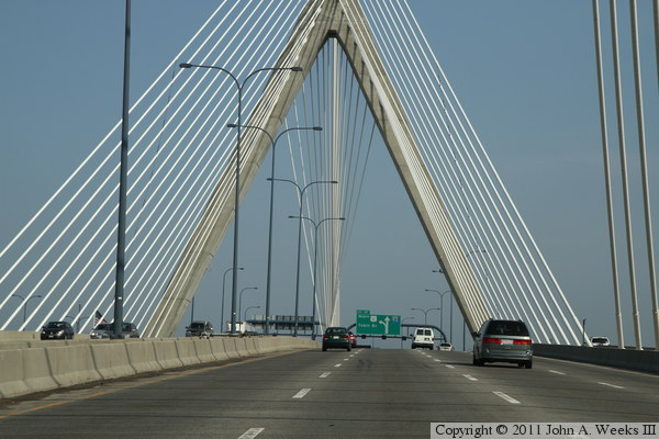
These two photos continue our northbound bridge crossing. In the photo above,
we are approaching the middle of the main bridge span. In the photo below,
we are approaching the north bridge tower. Note that some of the cables
that attach to the center of the roadway form an inverted V. That is due to
these cables attaching to the legs of the tower rather than the main vertical
section of the tower. This is also a very unusual cable configuration.
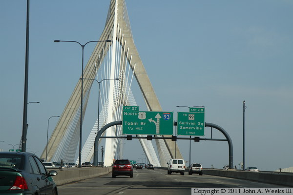
These two photos conclude our northbound bridge crossing. In the photo above,
we are nearing the end of the suspended span at the north end of the Zakim
Bridge. In the photo below, we are continuing northbound on the Interstate
highway I-93 elevated structure, heading into Sommerville after having passed
between Charlestown and Cambridge.

|